Rivey Hill
Rivey Hill is a hill overlooking Linton in Cambridgeshire (grid reference TL567480). At 367 feet (112 m) it is the highest point for several miles around. The hill has a steep slope leading down to Linton and a prominence of 69 feet (21 m). The highest point is on private land but a bridleway from Linton crosses near the top. A watertower on the hill identifies it when seen from a distance.
| Rivey Hill | |
|---|---|
| Highest point | |
| Elevation | 367 ft (112 m) |
| Prominence | 69 ft (21 m) |
| Listing | (none) |
| Geography | |
| Location | Cambridgeshire, England |
| OS grid | TL567480 |
| Topo map | OS Landranger 154 |
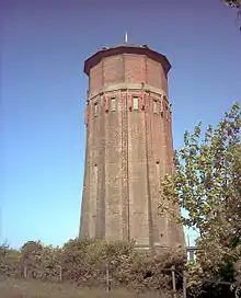
The watertower on Rivey Hill
The ascent of the hill is the start of a circular walk, detailed in Jarrold's Walks in Cambridgeshire, which goes north from the top to a Roman Road, follows this over the 312 feet (95 m) Hildersham Hill for 2 miles (3.2 km), then descends to Hildersham and returns along the valley of the River Granta to Linton.
This article is issued from Wikipedia. The text is licensed under Creative Commons - Attribution - Sharealike. Additional terms may apply for the media files.