Rivière-de-la-Savane, Quebec
Rivière-de-la-Savane is an unorganized territory in the Mauricie, province of Quebec, Canada, part of the Mékinac Regional County Municipality. This uninhabited territory includes among others the Irénée-Marie Ecological Reserve and Zec du Chapeau-de-Paille.
Rivière-de-la-Savane | |
|---|---|
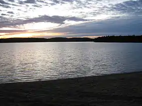 Lac des Aigles | |
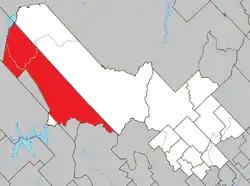 Location within Mékinac RCM | |
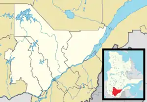 Rivière-de-la-Savane Location in central Quebec | |
| Coordinates: 47°03′N 73°38′W[1] | |
| Country | |
| Province | |
| Region | Mauricie |
| RCM | Mékinac |
| Constituted | March 13, 1986 |
| Government | |
| • Federal riding | Saint-Maurice—Champlain |
| • Prov. riding | Laviolette |
| Area | |
| • Total | 1,176.40 km2 (454.21 sq mi) |
| • Land | 1,088.02 km2 (420.09 sq mi) |
| Population (2011)[3] | |
| • Total | 0 |
| • Density | 0.0/km2 (0/sq mi) |
| • Pop 2006-2011 | |
| • Dwellings | 40 |
| Time zone | UTC−5 (EST) |
| • Summer (DST) | UTC−4 (EDT) |
| Highways | No major routes |
Geography
Located west of the Saint-Maurice River, the shape of this area resembles to the number "1" bent on 45 degrees to the northwest and its southern boundary is formed by the Matawin River. This area is located north of La Mauricie National Park. The northern boundary of this area is a straight line of 86.5 kilometres (53.7 mi) south-east to north-west, from the Matawin River to Mondonac Lake which defines the northwestern boundary of the territory.
Its entire area is forested.
References
- Reference number 149653 of the Commission de toponymie du Québec (in French)
- Ministère des Affaires municipales, des Régions et de l'Occupation du territoire - Répertoire des municipalités: Rivière-de-la-Savane
- Statistics Canada 2011 Census - Rivière-de-la-Savane census profile
External links
![]() Media related to Rivière-de-la-Savane at Wikimedia Commons
Media related to Rivière-de-la-Savane at Wikimedia Commons
Adjacent Municipal Subdivisions | ||||||||||
|---|---|---|---|---|---|---|---|---|---|---|
| ||||||||||
| Cities & towns | |
|---|---|
| Municipalities | |
| Parishes | |
| Villages | |
| Unorganized territories | |