Rivière des Rosiers
The rivière des Rosiers (in English: River of Roses) is a tributary of the Nicolet River which flows on the south shore of the St. Lawrence River. The Rosiers River flows through the municipalities of Tingwick, Kingsey Falls, Warwick, Sainte-Élizabeth-de-Warwick and Saint-Albert-de-Warwick, in the Arthabaska Regional County Municipality (MRC), in the Centre-du-Québec region, in Quebec, in Canada.
| Rivière des Rosiers | |
|---|---|
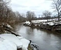 The Desrosiers river in Saint-Albert | |
 | |
| Location | |
| Country | Canada |
| Province | Quebec |
| Region | Centre-du-Québec |
| MRC | Arthabaska Regional County Municipality |
| Municipality | Tingwick, Kingsey Falls, Warwick, Sainte-Élizabeth-de-Warwick et de Saint-Albert-de-Warwick |
| Physical characteristics | |
| Source | La Montagne (Appalachian Mountains) |
| • location | Tingwick |
| • coordinates | 45.873774°N 71.869054°W |
| • elevation | 360 m (1,180 ft) |
| Mouth | Nicolet River |
• location | Saint-Albert |
• coordinates | 45.98667°N 72.12111°W |
• elevation | 103 m (338 ft) |
| Length | 35 km (22 mi) |
| Basin features | |
| Tributaries | |
| • left | (upstream) |
| • right | (upstream) |
Toponymy
The toponym "rivière des Rosiers" was made official on December 5, 1968 at the Commission de toponymie du Québec.[1]
Geography
Territory
The "rivière des Rosiers" watershed affects six municipalities, namely (from upstream to downstream) Saint-Rémi-de-Tingwick, Tingwick, Kingsey Falls, Warwick, Sainte-Élizabeth-de-Warwick and Saint-Albert.[2]
Course
The Rosiers River begins its course from 35 kilometres (22 mi) at Tingwick at an altitude of 360 metres (1,180 ft) at the foot of the Mountain, in the Appalachian Mountains. It then flows in a northwesterly direction to empty into the Nicolet River at Saint-Albert at an altitude of 103 metres (338 ft). The downstream portion of the river (length of 16 kilometres (9.9 mi)) was channeled at the start of XXth.[3]
Natural environment
The main forest species are sugar maple (Acer saccharum) and red maple (Acer rubrum).[5]
We find 12 species of fishes in the river. The main species are horned mullet (Semotilus atromaculatus), black sucker (Catostomus commersoni), belly-rotten (Pimephales notatus) and the Redfin Shiner (Luxilus cornutus).[6]
There are 39 species of bird x from 16 distinct families along the banks of the river. There are among others some species of buntings, warblers, swallows, tyrants, vireos, thrushes, and some representatives of corvids, such as the Raven and the Blue Jay.[7]
Notes and references
- Commission de toponymie du Québec - Place names bank - Toponym: "Rivière des Rosiers".
- Le Haut-Saint-François Regional County Municipality
- (Fort 2010, p. 6.)
- (Fort 2010, p. 13.)
- (Fort 2010, p. 11.)
- (Fort 2010, pp. 18–20.)
- (Fort 2010, p. 21.)
Further reading
- "Table de concertation du watershed de la rivière Desrosiers". Corporation for the promotion of the environment of the Nicolet river.
- Strong, Raphaël (2010). Corporation for the promotion of the environment of the Nicolet river (ed.). Portrait of the Desrosiers river watershed (PDF). p. 25.