Arthabaska Regional County Municipality
Arthabaska Regional County Municipality is a regional county municipality located in the Centre-du-Québec region of Quebec. Its seat is Victoriaville.[2]
Arthabaska | |
|---|---|
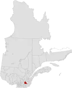 Location in Quebec | |
| Coordinates: 45°55′N 72°05′W[1] | |
| Country | Canada |
| Province | Quebec |
| Region | Centre-du-Québec |
| Effective | January 1, 1982 |
| County seat | Victoriaville |
| Government | |
| • Type | Prefecture |
| • Prefect | Lionel Fréchette |
| Area | |
| • Total | 1,910.60 km2 (737.69 sq mi) |
| • Land | 1,890.18 km2 (729.80 sq mi) |
| Population (2016)[3] | |
| • Total | 72,014 |
| • Density | 38.1/km2 (99/sq mi) |
| • Change 2011-2016 | |
| • Dwellings | 33,483 |
| Time zone | UTC−05:00 (EST) |
| • Summer (DST) | UTC−04:00 (EDT) |
| Area code(s) | 819 |
| Website | www |
| [4] | |
Subdivisions
There are 23 subdivisions within the RCM:[2]
|
|
|
|
Demographics
Mother tongue from 2016 Canadian Census[3]
| Language | Population | Pct (%) |
|---|---|---|
| French only | 69,175 | 97.1% |
| English only | 520 | 0.7% |
| Both English and French | 215 | 0.3% |
| Other languages | 1,335 | 1.9% |
Attractions
- Cinq-Chicots School of the Row (Saint-Christophe-d'Arthabaska)
- LaPierre Mill (Norbertville)
- Laurier Museum (Victoriaville)
- Marie-Victorin Park (Kingsey Falls)
- Postes Pavilion Hotel (Victoriaville)
- Rivière Nicolet Trout Fishing Post (Notre-Dame-de-Ham)
- Saint-Michel Mountain (Victoriaville)
- St-Médard Church (1874) (Warwick)
Transportation
Access Routes
Highways and numbered routes that run through the municipality, including external routes that start or finish at the county border:[5]
References
- Reference number 141121 of the Commission de toponymie du Québec (in French)
- Geographic code 390 in the official Répertoire des municipalités (in French)
- "Census Profile, 2016 Census: Arthabaska, Municipalité régionale de comté [Census division], Quebec". Statistics Canada. Retrieved November 26, 2019.
- "(Code 2439) Census Profile". 2011 census. Statistics Canada. 2012.
- Official Transport Quebec Road Map
External links
Adjacent Counties & Equivalent Territories | |
|---|---|
| Regional county municipalities and equivalent territories | |
|---|---|
| Municipalities | |
This article is issued from Wikipedia. The text is licensed under Creative Commons - Attribution - Sharealike. Additional terms may apply for the media files.