Roaring River (California)
The Roaring River is a 16.6-mile (26.7 km)[2] long tributary of the South Fork Kings River, in the Sierra Nevada of Fresno County, California. The entire course of the river is within Kings Canyon National Park.
| Roaring River | |
|---|---|
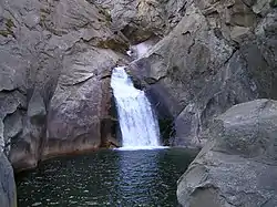 Roaring River Falls | |
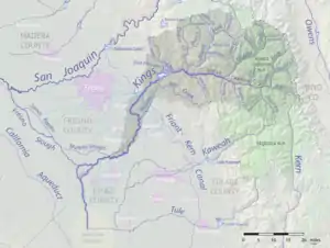 Map of the Kings River drainage basin. Roaring River joins the South Fork at right. | |
| Location | |
| Country | United States |
| State | California |
| Physical characteristics | |
| Source | Great Western Divide |
| • coordinates | 36°35′40″N 118°32′19″W[1] |
| • elevation | 11,505 ft (3,507 m) |
| Mouth | South Fork Kings River |
• location | Cedar Grove |
• coordinates | 36°47′08″N 118°37′36″W[1] |
• elevation | 4,790 ft (1,460 m) |
| Length | 16.6 mi (26.7 km)[2] |
| Basin size | 115.2 sq mi (298 km2)[2] |
The river originates in the Great Western Divide at Triple Divide Peak, and flows northward through Cloud Canyon before turning northwest, entering Sugarloaf Valley, where it receives Sugarloaf Creek from the west. From there it flows north through a deep and inaccessible gorge, forming the Roaring River Falls near its confluence with the South Fork in Cedar Grove.
See also
References
- "Roaring River". Geographic Names Information System. United States Geological Survey. 1981-01-19. Retrieved 2018-05-21.
- "National Hydrography Dataset via National Map Viewer". U.S. Geological Survey. Retrieved 2018-05-21.
This article is issued from Wikipedia. The text is licensed under Creative Commons - Attribution - Sharealike. Additional terms may apply for the media files.