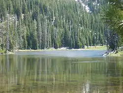
Roger Lake
Roger Lake (also called Rogers Lake or Rogers Pond) is a mountain pond located in a meadow on Aneroid Mountain in the Eagle Cap Wilderness of Northeastern Oregon, United States. It is 0.5 miles (0.8 km) from Aneroid Lake on trail 1804.[1] It is listed as the 29th highest lake in the Eagle Cap Wilderness[2]
| Roger Lake | |
|---|---|
 | |
 Roger Lake  Roger Lake | |
| Location | Eagle Cap Wilderness, Wallowa County, Oregon |
| Coordinates | 45.2085°N 117.1948°W |
| Type | Pond |
| Basin countries | United States |
| Max. length | 302 yd (276 m) |
| Max. width | 113 yd (103 m) |
| Average depth | 30 ft (9.1 m) |
| Max. depth | 46 ft (14 m) |
| Surface elevation | 7,360 ft (2,240 m) |
Trail
Roger Lake can be accessed by either the East Fork Wallowa River Trailhead at Wallowa Lake or the Tenderfoot Trailhead. The East Fork Wallowa River Trailhead is by far a shorter hike to Roger Lake, being only 5.5 miles (8.9 km) long. After about 2 miles (3 km) of hiking on the East Fork Wallowa River Trail, the climber will reach a small dam. At 3.8 miles (6.1 km) there is a small, well built bridge. The average depth of the lake is 30 feet (9 m), and the maximum depth is 46 feet (14 m). The trail is usually very well maintained.[3] It may be heavily traveled in the summer months.[4]
References
- Frank Barstad, Hiking Oregon's Eagle Cap Wilderness (c) 2002 Morris Book Publishing
- http://www.fs.fed.us/r6/w-w/recreation/wilderness/elevations-ecw.shtml Retrieved on November 21, 2008
- ^ http://www.trailsnw.com/index.php?fuseaction=Trails.DisplayTrail&hike_num=42 Retrieved 11/25/08
- ^ http://www.fs.fed.us/r6/w-w/recreation/trails-ec/1804_1831_1820_efork_wriv_124.shtml Retrieved on 11/25/08