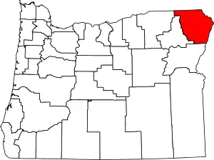
Wallowa County, Oregon
Wallowa County (/wəˈlaʊwə/) is one of the 36 counties in the U.S. state of Oregon. As of the 2010 census, the population was 7,008,[1] making it Oregon's fourth-least populous county. Its county seat is Enterprise.[2] According to Oregon Geographic Names, the origins of the county's name are uncertain, with the most likely explanation being it is derived from the Nez Perce term for a structure of stakes (a weir) used in fishing. An alternative explanation is that Wallowa is derived from a Nez Perce word for "winding water". The journals of Lewis and Clark Expedition record the name of the Wallowa River as Wil-le-wah.
Wallowa County | |
|---|---|
 | |
 Location within the U.S. state of Oregon | |
 Oregon's location within the U.S. | |
| Coordinates: 45°35′N 117°10′W | |
| Country | |
| State | |
| Founded | October 14, 1887 |
| Named for | Wallowa River |
| Seat | Enterprise |
| Largest city | Enterprise |
| Area | |
| • Total | 3,152 sq mi (8,160 km2) |
| • Land | 3,146 sq mi (8,150 km2) |
| • Water | 5.5 sq mi (14 km2) 0.2%% |
| Population (2010) | |
| • Total | 7,008 |
| • Estimate (2019) | 7,208 |
| • Density | 2.2/sq mi (0.8/km2) |
| Time zone | UTC−8 (Pacific) |
| • Summer (DST) | UTC−7 (PDT) |
| Congressional district | 2nd |
| Website | co |
Wallowa County is part of the eight-county definition of Eastern Oregon.
History
In 1871, the first white settlers came to the area, crossing the mountains in search of livestock feed in the Wallowa Valley. The county was established on February 11, 1887,[3] from the eastern portion of Union County. Boundary changes occurred with Union County in 1890, 1900, and 1915.
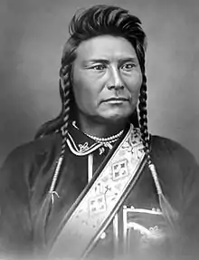
In 1877, the younger Chief Joseph of the Nez Perce, incensed at the government's attempt to remove his people from the Wallowa Valley, refused to relocate to the reservation in north central Idaho. Several regiments of U.S. Army cavalry troops were dispatched to force them onto the reservation. After numerous battles and a journey of almost two thousand miles (3,200 km), the Nez Perce fought their last battle at Bear Paw, just shy of the Canadian border, when Joseph and the other chiefs decided to stop fighting. He and some of the surviving Nez Perce were held in prison camps in Kansas and Oklahoma, and those who survived that were relocated to Colville Reservation in northeast Washington.[4] Approximately half of the survivors moved to the Nez Perce Reservation in Idaho. Chief Joseph last visited Wallowa County in 1902,[3] and died two years later.
Wallowa County was the scene of perhaps the worst incident of violence against Chinese in Oregon, when in May 1887 a gang of rustlers massacred 10-34 Chinese gold miners in Hells Canyon. Of the seven rustlers and schoolboys believed to have been responsible, only three were brought to trial in Enterprise, where a jury found them not guilty on September 1, 1888. A proposal to commemorate this event on official maps as Chinese Massacre Cove was approved in 2005 and encompasses a five-acre site.[5]
In 1896, the Joseph town bank was robbed and there was a shootout in the streets. The town has occasionally had re-enactments of that event.[6]
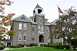
Wallowa County Courthouse was built in 1909–1910, using locally quarried Bowlby stone, a type of volcanic tuff. It is a Romanesque Revival-style building with Queen Anne architectural elements in some exterior features. The courthouse was listed on National Register of Historic Places in 2000. Today, it still houses Wallowa County government offices and faces west toward South River Street and is surrounded by Courthouse Square which encompasses one city block, approximately 1.3 acres (1 ha). The square is landscaped with oak, pine, maple, linden, juniper, and flowering crab apple trees. There are roses planted on the north, west, and south sides of the courthouse. The square also has several veteran memorials along with a 20-by-24-foot (6.1 by 7.3 m) wood-framed gazebo in the northeast corner of the square.[7][8][9]
United States Supreme Court Associate Justice William O. Douglas was one famous summer visitor to Wallowa County, building a vacation cabin on Lostine River Road in 1939.
In December 2003, a developer announced a proposal to buy a 62-acre (0.25 km2) property near Wallowa Lake, and build 11 homes on it. This property is adjacent to the property that is home to the grave of Old Chief Joseph, father of the younger Chief Joseph. This proposal drew opposition from a local group, as well as from the Nez Perce, Colville, and Umatilla tribes. Prior offers by the National Park Service and the Trust for Public Land to buy the land were rejected. The County commissioners gave conditional approval for the developers to complete a final plat of the land on February 13, 2004, but the attorney for the Nez Perce said the tribe would appeal the decision to the Oregon Land Use Board of Appeals. As of 2016, the controversy was still active.[10]
Geography
Wallowa is the northeasternmost county of Oregon. According to the U.S. Census Bureau, the county has a total area of 3,152 square miles (8,160 km2), of which 3,146 square miles (8,150 km2) is land and 5.5 square miles (14 km2) (0.2%) is water.[11]
Geographic features
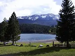
Wallowa Lake and the Wallowa Mountains attract tourists to this region. The lake is a natural glacial formation, held in on three sides by prominent moraines. The microclimate is somewhat different from the surrounding areas and provides a cool retreat during the summer. Other geographic features include:
Adjacent counties
- Columbia County, Washington - northwest
- Garfield County, Washington - north
- Asotin County, Washington - northeast
- Nez Perce County, Idaho - northeast
- Idaho County, Idaho - east/Mountain Time Border
- Adams County, Idaho - southeast/Mountain Time Border
- Baker County (south)
- Union County (southwest)
- Umatilla County (west)
National protected areas
Demographics
| Historical population | |||
|---|---|---|---|
| Census | Pop. | %± | |
| 1890 | 3,661 | — | |
| 1900 | 5,538 | 51.3% | |
| 1910 | 8,364 | 51.0% | |
| 1920 | 9,778 | 16.9% | |
| 1930 | 7,814 | −20.1% | |
| 1940 | 7,623 | −2.4% | |
| 1950 | 7,264 | −4.7% | |
| 1960 | 7,102 | −2.2% | |
| 1970 | 6,247 | −12.0% | |
| 1980 | 7,273 | 16.4% | |
| 1990 | 6,911 | −5.0% | |
| 2000 | 7,226 | 4.6% | |
| 2010 | 7,008 | −3.0% | |
| 2019 (est.) | 7,208 | [12] | 2.9% |
| U.S. Decennial Census[13] 1790-1960[14] 1900-1990[15] 1990-2000[16] 2010-2019[1] | |||
2000 census
At the 2000 census there were 7,226 people, 3,029 households, and 2,083 families residing in the county. The population density was 2 people per square mile (1/km2). There were 3,900 housing units at an average density of 1 per square mile (0/km2). The racial makup of the county was 96.50% White, 0.03% Black or African American, 0.71% Native American, 0.24% Asian, 0.04% Pacific Islander, 0.95% from other races, and 1.54% from two or more races. 1.73%.[17] were Hispanic or Latino of any race. 21.8% were of German, 15.7% American, 12.3% English and 11.8% Irish ancestry.
Of the 3,029 households 28.50% had children under the age of 18 living with them, 58.70% were married couples living together, 6.90% had a female householder with no husband present, and 31.20% were non-families. 27.10% of households were one person and 11.90% were one person aged 65 or older. The average household size was 2.35 and the average family size was 2.85.
The age distribution was 24.30% under the age of 18, 4.90% from 18 to 24, 21.90% from 25 to 44, 30.00% from 45 to 64, and 18.90% 65 or older. The median age was 44 years. For every 100 females there were 100.10 males. For every 100 females age 18 and over, there were 96.10 males.
The median household income was $32,129 and the median family income was $38,682. Males had a median income of $28,202 versus $21,558 for females. The per capita income for the county was $17,276. About 9.80% of families and 14.00% of the population were below the poverty line, including 18.30% of those under age 18 and 11.40% of those age 65 or over.
2010 census
As of the 2010 United States Census, there were 7,008 people, 3,133 households, and 2,024 families residing in the county.[18] The population density was 2.2 inhabitants per square mile (0.85/km2). There were 4,108 housing units at an average density of 1.3 per square mile (0.50/km2).[19] The racial makeup of the county was 96.0% white, 0.6% American Indian, 0.4% black or African American, 0.3% Asian, 0.1% Pacific islander, 0.5% from other races, and 2.0% from two or more races. Those of Hispanic or Latino origin made up 2.2% of the population.[18] In terms of ancestry, 28.4% were German, 16.7% were English, 14.6% were Irish, 7.3% were American, and 5.4% were Scotch-Irish.[20]
Of the 3,133 households, 22.3% had children under the age of 18 living with them, 54.3% were married couples living together, 7.1% had a female householder with no husband present, 35.4% were non-families, and 30.0% of households were made up of individuals. The average household size was 2.20 and the average family size was 2.70. The median age was 50.5 years.[18]
The median income for a household in the county was $41,116 and the median family income was $49,961. Males had a median income of $35,963 versus $29,395 for females. The per capita income for the county was $23,023. About 9.6% of families and 12.9% of the population were below the poverty line, including 17.4% of those under age 18 and 10.6% of those age 65 or over.[21]
Communities
Incorporated cities
- Enterprise (county seat)
- Joseph
- Lostine
- Wallowa
Census-designated place
Politics
State Legislature
Wallowa County is located in Oregon State House District 58 which is currently represented by Greg Barreto. It is also located in Oregon State Senate District 29, represented by Bill Hansell. Both Barreto and Hansell are registered Republicans.[22]
Board of Commissioners
Wallowa County is represented and governed by three County Commissioners. The Wallowa County Board of Commissioners is currently made up of Susan Roberts, Paul Castilleja and John Lawrence.[23] Susan Roberts is a former Mayor of Enterprise and was elected onto the Board of Commissioners in 2008.[24] Paul Castilleja is a former Mayor of Joseph and was elected in 2010. John Lawrence was appointed in 2016 to succeed Mike Hayward, who had resigned. The seats are nonpartisan, although all three commissioners are registered Republicans.[24][25][26]
Make-up of voters
Like all counties in eastern Oregon, the majority of registered voters who are part of a political party in Wallowa County are members of the Republican Party. In the 2008 presidential election, 63.52% of Wallowa County voters voted for Republican John McCain, while 33.42% voted for Democrat Barack Obama and 3.06% of voters either voted for a Third Party candidate or wrote in a candidate.[27] These numbers have changed slightly from the 2004 presidential election, in which 69.3% voted for George W. Bush, while 28.1% voted for John Kerry, and 2.6% of voters either voted for a Third Party candidate or wrote in a candidate.[28]
.gif)
| Year | Republican | Democratic | Third parties |
|---|---|---|---|
| 2016 | 65.2% 2,848 | 25.6% 1,116 | 9.2% 402 |
| 2012 | 66.7% 2,804 | 29.8% 1,253 | 3.5% 148 |
| 2008 | 63.5% 2,836 | 33.4% 1,492 | 3.1% 137 |
| 2004 | 69.3% 3,132 | 28.1% 1,269 | 2.7% 120 |
| 2000 | 76.4% 3,279 | 19.5% 836 | 4.2% 179 |
| 1996 | 55.4% 2,379 | 30.7% 1,321 | 13.9% 597 |
| 1992 | 40.0% 1,630 | 29.5% 1,203 | 30.5% 1,241 |
| 1988 | 56.9% 1,993 | 40.7% 1,425 | 2.4% 85 |
| 1984 | 68.4% 2,619 | 31.4% 1,204 | 0.2% 8 |
| 1980 | 65.5% 2,485 | 26.2% 995 | 8.2% 312 |
| 1976 | 53.8% 1,693 | 41.6% 1,310 | 4.6% 146 |
| 1972 | 62.3% 1,909 | 29.3% 899 | 8.4% 257 |
| 1968 | 55.7% 1,527 | 36.7% 1,006 | 7.6% 209 |
| 1964 | 37.0% 1,055 | 62.9% 1,790 | 0.1% 3 |
| 1960 | 46.1% 1,440 | 53.8% 1,682 | 0.1% 3 |
| 1956 | 48.2% 1,604 | 51.8% 1,723 | |
| 1952 | 59.4% 1,891 | 39.9% 1,271 | 0.7% 21 |
| 1948 | 44.7% 1,196 | 52.6% 1,408 | 2.7% 71 |
| 1944 | 42.3% 1,152 | 56.7% 1,544 | 0.9% 25 |
| 1940 | 39.8% 1,319 | 59.6% 1,974 | 0.5% 18 |
| 1936 | 25.9% 811 | 63.9% 2,000 | 10.3% 321 |
| 1932 | 29.1% 772 | 67.5% 1,790 | 3.4% 90 |
| 1928 | 56.9% 1,326 | 40.1% 935 | 3.0% 71 |
| 1924 | 46.3% 1,253 | 35.9% 973 | 17.8% 481 |
| 1920 | 60.3% 1,612 | 33.5% 896 | 6.2% 166 |
| 1916 | 35.8% 1,198 | 58.5% 1,960 | 5.8% 193 |
| 1912 | 19.3% 353 | 33.3% 610 | 47.4% 869[lower-alpha 1] |
| 1908 | 58.7% 905 | 32.8% 506 | 8.5% 131 |
| 1904 | 64.3% 714 | 23.0% 255 | 12.7% 141 |
Economy
The principal industries in Wallowa County are agriculture, ranching, lumber, and tourism. Since 1985, three bronze foundries and a number of related businesses specializing in statue-making have opened in Joseph and Enterprise, helping to stabilize the local economy. The Forest Service is the largest landlord in the county, owning 56% of the land.
Transportation
Major highways
 – Oregon Route 3 – north to Washington, becomes
  Route 129
 – Oregon Route 82 – west to La Grande, the junction with
  Interstate 84
Railroads
- Eagle Cap Excursion Train (part)
Notable people
Notes
- The leading "other" candidate, Progressive Theodore Roosevelt, received 600 votes, while Socialist Eugene Debs received 214 votes, Prohibition candidate Eugene Chafin received 55 votes.
References
- "State & County QuickFacts". United States Census Bureau. Retrieved November 15, 2013.
- "Find a County". National Association of Counties. Retrieved June 7, 2011.
- Bailey, Barbara Ruth (1982). Main Street: Northeastern Oregon. Oregon Historical Society. pp. 5, 28. ISBN 0-87595-073-6.
- "Chief Joseph". Online Highways LLC. 2010. Retrieved March 5, 2010.
- Nokes, R. Gregory. 2009. Massacred for Gold. Corvallis, Oregon: Oregon State University Press.
- "Taste of Joseph". Wallowa County Chieftain. Retrieved February 15, 2018.
- Wallowa County Courthouse, National Register of Historic Places Inventory—Nomination Form, National Park Service, United States Department of the Interior, Washington, D.C., 18 May 2000.
- Historic Wallowa County Courthouse, Wallowa County, www.co.wallowa.or.us, Enterprise, Oregon, 2009.
- The Wallowa County Courthouse, City of Enterprise, enterpriseoregon.org, Enterprise Oregon, July 29, 2012.
- "Kriegers won't sell land to government". La Grande observer. Retrieved February 15, 2018.
- "2010 Census Gazetteer Files". United States Census Bureau. August 22, 2012. Retrieved February 28, 2015.
- "Population and Housing Unit Estimates". Retrieved March 26, 2020.
- "U.S. Decennial Census". United States Census Bureau. Retrieved February 28, 2015.
- "Historical Census Browser". University of Virginia Library. Retrieved February 28, 2015.
- Forstall, Richard L., ed. (March 27, 1995). "Population of Counties by Decennial Census: 1900 to 1990". United States Census Bureau. Retrieved February 28, 2015.
- "Census 2000 PHC-T-4. Ranking Tables for Counties: 1990 and 2000" (PDF). United States Census Bureau. April 2, 2001. Retrieved February 28, 2015.
- "U.S. Census website". United States Census Bureau. Retrieved January 31, 2008.
- "DP-1 Profile of General Population and Housing Characteristics: 2010 Demographic Profile Data". United States Census Bureau. Archived from the original on February 13, 2020. Retrieved February 23, 2016.
- "Population, Housing Units, Area, and Density: 2010 - County". United States Census Bureau. Archived from the original on February 13, 2020. Retrieved February 23, 2016.
- "DP02 SELECTED SOCIAL CHARACTERISTICS IN THE UNITED STATES – 2006-2010 American Community Survey 5-Year Estimates". United States Census Bureau. Archived from the original on February 13, 2020. Retrieved February 23, 2016.
- "DP03 SELECTED ECONOMIC CHARACTERISTICS – 2006-2010 American Community Survey 5-Year Estimates". United States Census Bureau. Archived from the original on February 13, 2020. Retrieved February 23, 2016.
- "The Voter's Self Defense System".
- "Board of Commissioners".
- "Retrieved 11/17/09". lagrandeobserver.com. Retrieved 9 April 2018.
- "Retrieved November 17, 2009". lagrandeobserver.com. Retrieved April 9, 2018.
- "404 Page not found - La Grande News, Weather, Sports - LaGrandeObserver.com". Cite uses generic title (help)
- "Retrieved on April 21, 2009". uselectionatlas.org. Retrieved April 9, 2018.
- "Wallowa County, Oregon detailed profile - houses, real estate, cost of living, wages, work, agriculture, ancestries, and more".
- "Oregon Elections Division Voter Registration by County".
- Leip, David. "Dave Leip's Atlas of U.S. Presidential Elections". uselectionatlas.org. Retrieved April 9, 2018.
- Finn, Robin (October 25, 2012). "Margaret Osborne duPont, Tennis Champion, Dies at 94". The New York Times. Retrieved April 28, 2014.
External links
![]() Media related to Wallowa County, Oregon at Wikimedia Commons
Media related to Wallowa County, Oregon at Wikimedia Commons
Municipalities and communities of Wallowa County, Oregon, United States | ||
|---|---|---|
| Cities | Wallowa County map | |
| CDP | ||
| Other unincorporated communities | ||
| Ghost towns | ||
| ||

| Authority control |
|---|