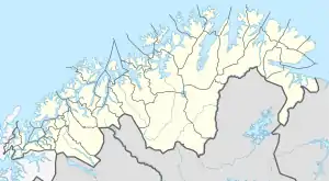
Rolla (Troms)
Rolla (Norwegian) or Rálli (Northern Sami) is an island in Ibestad Municipality in Troms og Finnmark county, Norway. The island of Andørja lies to the northeast, the Vågsfjorden lies to the north and west, and the Astafjorden lies to the south. The highest point on the 106-square-kilometre (41 sq mi) island of Rolla is Drangen at a height of 1,022 metres (3,353 ft). The population on Rolla (2001) is 1,078.[1][2]

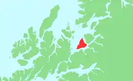 | |
 Rolla Location of the island  Rolla Rolla (Norway) | |
| Geography | |
|---|---|
| Location | Troms og Finnmark, Norway |
| Coordinates | 68.8237°N 17.0035°E |
| Area | 106.4 km2 (41.1 sq mi) |
| Length | 17 km (10.6 mi) |
| Width | 10.5 km (6.52 mi) |
| Coastline | 47 km (29.2 mi) |
| Highest elevation | 1,022 m (3353 ft) |
| Highest point | Drangen |
| Administration | |
Norway | |
| County | Troms og Finnmark |
| Municipality | Ibestad Municipality |
| Largest settlement | Hamnvik (pop. 470) |
| Demographics | |
| Population | 1078 (2001) |
| Pop. density | 10.1/km2 (26.2/sq mi) |
Rolla is connected to the neighboring island of Andørja by the undersea Ibestad Tunnel located in Hamnvik. Andørja is then connected to the mainland via the Mjøsund Bridge. There is a ferry connection from Sørrollnes on the western coast to the town of Harstad.
There are two main churches on the island: Ibestad Church in Hamnvik and Sørrollnes Chapel in Sørrollnes.
References
- Statistisk sentralbyrå (2001). "Folke- og boligtellingen 2001, kommune- og bydelshefter 1917 Ibestad" (PDF) (in Norwegian). Cite journal requires
|journal=(help) - Store norske leksikon. "Rolla" (in Norwegian). Retrieved 2010-04-04.
