Root River State Trail
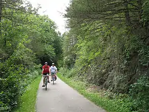
Root River State Trail is a 60-mile (97 km) paved multi-use rail trail system in southeast Minnesota. The trail system consists of two main segments, the Root River segment, and Harmony-Preston Valley segment. The trails are used mainly for bicycling, hiking, and inline skating in the summer, and for cross country skiing in the winter. Much of the trail, especially the Root River segment, is built along a former Milwaukee Road (Chicago, Milwaukee, St. Paul and Pacific Railroad) railbed following the contours of the Root River valley. The trail was originally paved in the 1980s, and repaved by June 2008.[1]
Root River segment
42.3 miles (68.1 km) in length, the trail runs predominantly east/west, following the meanders of the Root River for much of the distance. Because most of this trail segment was constructed on an abandoned rail grade, most of the inclines and curves are quite gradual.
The trail intersects six towns along the way:
- 0 miles (0 km) - Fountain, Minnesota (western terminus of trail segment)
- 6.5 miles (10.5 km) - junction with Harmony-Preston Valley segment
- 11.2 miles (18.0 km) - Lanesboro, Minnesota
- 15.8 miles (25.4 km) - Whalan, Minnesota
- 24.7 miles (39.8 km) - Peterson, Minnesota
- 29.5 miles (47.5 km) - Rushford, Minnesota
- 42.3 miles (68.1 km) - Houston, Minnesota (eastern terminus of trail segment)
Harmony-Preston Valley segment
17.8 miles (28.6 km) in length, the trail runs predominantly north/south. The trail follows the Root River only from the junction to Preston. South of Preston, the trail is no longer built on a former rail grade, causing the inclines to be steeper in areas. Nearing Harmony, the trail begins to form sharp right angles as it cuts between existing farm fields and properties.[2]
This segment of the trail intersects two towns:
- 0 miles (0 km) - junction with Root River segment (northern terminus of trail segment)
- 5.5 miles (8.9 km) - Preston, Minnesota
- 17.8 miles (28.6 km) - Harmony, Minnesota (southern terminus of trail segment)
References
- "Root River Trail Repaired and Ready for Riding". Outdoor Central. 2008-05-09. Retrieved 2009-02-16.
- http://files.dnr.state.mn.us/maps/state_trails/rootriver_harmonypreston.pdf
External links
- Minnesota DNR: Root River State Trail
- Minnesota DNR: trail map
- Trails from Rails: area businesses catering to trail users, listed by town
| Central/Metro | ||
|---|---|---|
| Northeast | ||
| Northwest | ||
| Southeast | ||
| Southwest | ||