Rotan, Texas
Rotan is a city in Fisher County, Texas, United States. The population was 1,508 at the 2010 census,[5] down from 1,611 at the 2000 census.
Rotan, Texas | |
|---|---|
.jpg.webp) Rotan, Texas | |
 Rotan  Rotan | |
| Coordinates: 32°51′19″N 100°27′54″W | |
| Country | United States |
| State | Texas |
| County | Fisher |
| Area | |
| • Total | 2.02 sq mi (5.24 km2) |
| • Land | 2.02 sq mi (5.24 km2) |
| • Water | 0.00 sq mi (0.00 km2) |
| Elevation | 1,949 ft (594 m) |
| Population (2010) | |
| • Total | 1,508 |
| • Estimate (2019)[2] | 1,438 |
| • Density | 710.83/sq mi (274.51/km2) |
| Time zone | UTC-6 (Central (CST)) |
| • Summer (DST) | UTC-5 (CDT) |
| ZIP code | 79546 |
| Area code(s) | 325 |
| FIPS code | 48-63464[3] |
| GNIS feature ID | 1345626[4] |
Geography
Texas State Highway 70 passes through the city, leading north 34 miles (55 km) to Jayton and south 9 miles (14 km) to Roby, the Fisher County seat, and 30 miles (48 km) to Sweetwater and Interstate 20. Texas State Highway 92 leads east from Rotan 20 miles (32 km) to Hamlin.
According to the United States Census Bureau, Rotan has a total area of 2.0 mi2 (5.2 km2), all of it land.[5]
Climate
Rotan's climate type occurs primarily on the periphery of the true deserts in low-latitude semiarid steppe regions. The Köppen climate classification subtype for this climate is BSh (tropical and subtropical steppe climate).[6]
| Climate data for Rotan, Texas | |||||||||||||
|---|---|---|---|---|---|---|---|---|---|---|---|---|---|
| Month | Jan | Feb | Mar | Apr | May | Jun | Jul | Aug | Sep | Oct | Nov | Dec | Year |
| Average high °C (°F) | 14 (57) |
17 (62) |
22 (71) |
27 (80) |
31 (87) |
34 (93) |
36 (96) |
35 (95) |
31 (87) |
26 (79) |
19 (67) |
14 (58) |
26 (78) |
| Average low °C (°F) | −1 (31) |
1 (34) |
5 (41) |
10 (50) |
16 (60) |
19 (67) |
22 (71) |
21 (69) |
17 (63) |
11 (52) |
5 (41) |
0 (32) |
11 (51) |
| Average precipitation mm (inches) | 20 (0.8) |
33 (1.3) |
33 (1.3) |
48 (1.9) |
91 (3.6) |
69 (2.7) |
53 (2.1) |
71 (2.8) |
79 (3.1) |
61 (2.4) |
33 (1.3) |
28 (1.1) |
620 (24.3) |
| Source: Weatherbase [7] | |||||||||||||
Demographics
| Historical population | |||
|---|---|---|---|
| Census | Pop. | %± | |
| 1910 | 1,126 | — | |
| 1920 | 1,000 | −11.2% | |
| 1930 | 1,632 | 63.2% | |
| 1940 | 2,029 | 24.3% | |
| 1950 | 3,163 | 55.9% | |
| 1960 | 2,788 | −11.9% | |
| 1970 | 2,404 | −13.8% | |
| 1980 | 2,284 | −5.0% | |
| 1990 | 1,913 | −16.2% | |
| 2000 | 1,611 | −15.8% | |
| 2010 | 1,508 | −6.4% | |
| 2019 (est.) | 1,438 | [2] | −4.6% |
| U.S. Decennial Census[8] | |||
As of the census[3] of 2000, 1,611 people, 665 households, and 442 families resided in the city. The population density was 791.3 people per square mile (304.9/km2). The 841 housing units averaged 413.1 per square mile (159.2/km2). The racial makeup of the city was 72.44% White, 5.59% African American, 0.25% Native American, 0.19% Asian, 19.49% from other races, and 2.05% from two or more races. Hispanics or Latinos of any race were 32.90% of the population.
Of the 665 households, 28.0% had children under the age of 18 living with them, 51.6% were married couples living together, 11.9% had a female householder with no husband present, and 33.5% were not families; 32.3% of all households were made up of individuals, and 21.4% had someone living alone who was 65 years of age or older. The average household size was 2.35 and the average family size was 2.95.
In the city, the population was distributed as 24.6% under the age of 18, 8.0% from 18 to 24, 22.2% from 25 to 44, 21.7% from 45 to 64, and 23.5% who were 65 years of age or older. The median age was 41 years. For every 100 females, there were 87.3 males. For every 100 females age 18 and over, there were 82.2 males.
The median income for a household in the city was $21,638, and for a family was $29,038. Males had a median income of $25,688 versus $17,045 for females. The per capita income for the city was $13,097. About 16.6% of families and 22.6% of the population were below the poverty line, including 39.0% of those under age 18 and 11.9% of those age 65 or over.
Education
The city is served by the Rotan Independent School District.
Notable people
- Sammy Baugh, quarterback for the Washington Redskins, had a ranch in Rotan. He lived there many years and died there on December 17, 2008, at the age of 94.[9]
- Ella Hudson Day, composer, was one of the first to live here.
References
- "2019 U.S. Gazetteer Files". United States Census Bureau. Retrieved August 7, 2020.
- "Population and Housing Unit Estimates". United States Census Bureau. May 24, 2020. Retrieved May 27, 2020.
- "U.S. Census website". United States Census Bureau. Retrieved 2008-01-31.
- "US Board on Geographic Names". United States Geological Survey. 2007-10-25. Retrieved 2008-01-31.
- "Geographic Identifiers: 2010 Demographic Profile Data (G001): Rotan city, Texas". U.S. Census Bureau, American Factfinder. Retrieved August 25, 2016.
- Climate Summary for Rotan, Texas
- "Weatherbase.com". Weatherbase. 2013. Retrieved on August 14, 2013.
- "Census of Population and Housing". Census.gov. Retrieved June 4, 2015.
- Goldstein, Richard. - "Sammy Baugh, N.F.L. Great, Dies at 94". - New York Times. - December 17, 2008.
Municipalities and communities of Fisher County, Texas, United States | ||
|---|---|---|
| Cities | 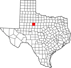 Fisher County map | |
| Unincorporated communities | ||
| Ghost towns | ||
| Footnotes | ‡This populated place also has portions in an adjacent county or counties | |
| ||
| Authority control |
|
|---|
