Rowsley, Victoria
Rowsley is a rural locality in Victoria, Australia. The locality is approximately 50 kilometres (31 mi) west of Melbourne in the Shire of Moorabool local government area.
| Rowsley Victoria | |||||||||||||||
|---|---|---|---|---|---|---|---|---|---|---|---|---|---|---|---|
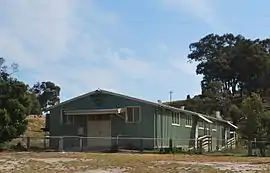
 Public hall | |||||||||||||||
 Rowsley | |||||||||||||||
| Coordinates | 37°43′S 144°22′E | ||||||||||||||
| Population | 192 (2016 census)[1] | ||||||||||||||
| Postcode(s) | 3340 | ||||||||||||||
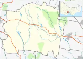
| Location | |||||||||||||||
| LGA(s) | Shire of Moorabool | ||||||||||||||
| State electorate(s) | Melton | ||||||||||||||
| Federal Division(s) | Ballarat | ||||||||||||||
| |||||||||||||||
History
The post office there opened on 12 May 1890, closed on 30 April 1962, reopened on 1 January 1946 and was closed in 1950.[2]
Greystones Homestead, a historic homestead located at 565 Glenmore Road, Rowsley, is listed on the Victorian Heritage Register. Dating from 1875–1876, the property was purchased by prominent businessman William Charles Angliss in 1934 and was still held by his descendants in 2003.[3]
References
- Australian Bureau of Statistics (27 June 2017). "Rowsley (State Suburb)". 2016 Census QuickStats. Retrieved 18 March 2018.

- Premier Postal History, Post Office List, retrieved 11 April 2008
- "Greystones Homestead (H0265)". Victorian Heritage Register. Heritage Victoria. Retrieved 7 July 2014.
This article is issued from Wikipedia. The text is licensed under Creative Commons - Attribution - Sharealike. Additional terms may apply for the media files.