Roxobel, North Carolina
Roxobel is a town in northwestern Bertie County, North Carolina, United States. It dates to 1724 and was originally known as Cotten's Cross Roads. After several name changes, it has remained Roxobel since 1849. The population was 240 at the 2010 census.[5]
Roxobel, North Carolina | |
|---|---|
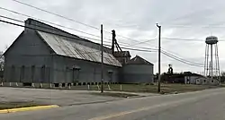 | |
| Nickname(s): Peanut Town, Red Refuge, North Kelford | |
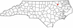 Location of Roxobel, North Carolina | |
| Coordinates: 36°12′10″N 77°14′15″W | |
| Country | United States |
| State | North Carolina |
| County | Bertie |
| Government | |
| • Steward | Lenore Walston |
| Area | |
| • Total | 1.04 sq mi (2.70 km2) |
| • Land | 1.04 sq mi (2.70 km2) |
| • Water | 0.00 sq mi (0.00 km2) |
| Elevation | 95 ft (29 m) |
| Population (2010) | |
| • Total | 240 |
| • Estimate (2019)[2] | 212 |
| • Density | 203.26/sq mi (78.48/km2) |
| Time zone | UTC-5 (Eastern (EST)) |
| • Summer (DST) | UTC-4 (EDT) |
| ZIP code | 27872 |
| Area code(s) | 252 |
| FIPS code | 37-58180[3] |
| GNIS feature ID | 1022434[4] |
History
Oaklana, Pineview, and Woodbourne are listed on the National Register of Historic Places.[6]
Geography
Roxobel is located at 36°12′10″N 77°14′15″W (36.202704, -77.237566).[7]
According to the United States Census Bureau, the town has a total area of 1.0 square mile (2.7 km2), all of it land.[5]
Demographics
| Historical population | |||
|---|---|---|---|
| Census | Pop. | %± | |
| 1900 | 227 | — | |
| 1910 | 491 | 116.3% | |
| 1920 | 330 | −32.8% | |
| 1930 | 334 | 1.2% | |
| 1940 | 332 | −0.6% | |
| 1950 | 394 | 18.7% | |
| 1960 | 452 | 14.7% | |
| 1970 | 347 | −23.2% | |
| 1980 | 278 | −19.9% | |
| 1990 | 244 | −12.2% | |
| 2000 | 263 | 7.8% | |
| 2010 | 240 | −8.7% | |
| 2019 (est.) | 212 | [2] | −11.7% |
| U.S. Decennial Census[8] | |||
As of the census[3] of 2000, there were 263 people, 112 households, and 72 families residing in the town. The population density was 254.7 people per square mile (98.6/km2). There were 121 housing units at an average density of 117.2 per square mile (45.4/km2). The racial makeup of the town was 51.33% White, 46.39% African American, 1.52% from other races, and 0.76% from two or more races. Hispanic or Latino of any race were 1.14% of the population.
There were 112 households, out of which 26.8% had children under the age of 18 living with them, 42.9% were married couples living together, 15.2% had a female householder with no husband present, and 35.7% were non-families. 29.5% of all households were made up of individuals, and 18.8% had someone living alone who was 65 years of age or older. The average household size was 2.35 and the average family size was 2.90.
In the town, the population was spread out, with 21.3% under the age of 18, 10.3% from 18 to 24, 23.2% from 25 to 44, 22.4% from 45 to 64, and 22.8% who were 65 years of age or older. The median age was 42 years. For every 100 females, there were 89.2 males. For every 100 females age 18 and over, there were 88.2 males.
The median income for a household in the town was $28,393, and the median income for a family was $28,036. Males had a median income of $20,833 versus $14,063 for females. The per capita income for the town was $12,798. About 10.5% of families and 12.3% of the population were below the poverty line, including 11.1% of those under the age of eighteen and 17.6% of those 65 or over.
References
- "2019 U.S. Gazetteer Files". United States Census Bureau. Retrieved July 27, 2020.
- "Population and Housing Unit Estimates". United States Census Bureau. May 24, 2020. Retrieved May 27, 2020.
- "U.S. Census website". United States Census Bureau. Retrieved 2008-01-31.
- "US Board on Geographic Names". United States Geological Survey. 2007-10-25. Retrieved 2008-01-31.
- "Geographic Identifiers: 2010 Demographic Profile Data (G001): Roxobel town, North Carolina". U.S. Census Bureau, American Factfinder. Archived from the original on February 12, 2020. Retrieved February 6, 2014.
- "National Register Information System". National Register of Historic Places. National Park Service. July 9, 2010.
- "US Gazetteer files: 2010, 2000, and 1990". United States Census Bureau. 2011-02-12. Retrieved 2011-04-23.
- "Census of Population and Housing". Census.gov. Retrieved June 4, 2015.
External links
Municipalities and communities of Bertie County, North Carolina, United States | ||
|---|---|---|
| Towns | 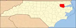 | |
| Unincorporated communities | ||
| ||
| Authority control |
|---|