Rudnik District
The Rudnik District (pronounced [ˈɾuːdnik], Slovene: Četrtna skupnost Rudnik), or simply Rudnik, is a district (mestna četrt) of the City Municipality of Ljubljana, the capital of Slovenia. It is named after the former village of Rudnik.
Rudnik District
Četrtna skupnost Rudnik | |
|---|---|
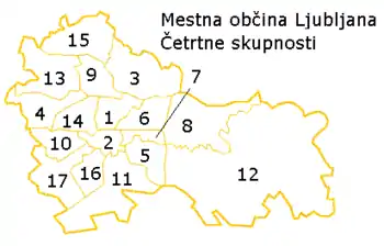 Map of districts in Ljubljana. The Rudnik District is number 11. | |
 Rudnik District Location in Slovenia | |
| Coordinates: 46°1′8.01″N 14°32′43.34″E | |
| Country | |
| Traditional region | Lower Carniola |
| Statistical region | Central Slovenia |
| Municipality | Ljubljana |
| Area | |
| • Total | 25.48 km2 (9.84 sq mi) |
| Population (2014) | |
| • Total | 13,558 |
| [1] | |
Geography
The Rudnik District is bounded on the northwest by the Ljubljanica River, on the northeast by the crest of Golovec Hill, and on the south by the A2 Freeway and a line running through the Ljubljana Marsh. The district includes the former village of Rudnik and the marsh hamlets of Ilovica, Volar, Pri Strahu, Pri Maranzu, Kožuh, and Havptmance.
References
- City of Ljubljana Districts (in Slovene)
External links
- Rudnik District homepage
 Media related to Rudnik District at Wikimedia Commons
This article is issued from Wikipedia. The text is licensed under Creative Commons - Attribution - Sharealike. Additional terms may apply for the media files.