Rukuhia railway station
Rukuhia railway station was a station on the North Island Main Trunk in New Zealand, located in the settlement of Rukuhia.[2][3] It was established during an extension of the railway line in the 1870s.[4][5]
Rukuhia railway station | |
|---|---|
| Location | Rukuhia New Zealand |
| Coordinates | 37.863606°S 175.28266°E |
| Elevation | 55 m (180 ft) |
| Line(s) | North Island Main Trunk |
| Distance | Hamilton 8.45 km (5.25 mi) Ohaupo 6.68 km (4.15 mi) Wellington 527.16 km (327.56 mi) |
| History | |
| Opened | 4 June 1878 |
| Closed | 12 September 1971[1] |
| Electrified | June 1988 |
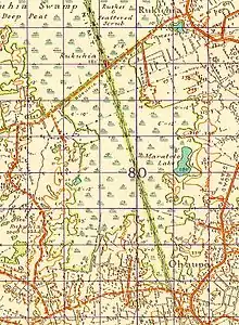
1946 one inch to one mile map (Source- Land Information New Zealand (LINZ) and licensed by LINZ for re-use under the Creative Commons Attribution 3.0 New Zealand licence)
Tests in 1981 found that the track deformed by about 12mm each time a train went over it, due to the peat swamp.[6]
References
- Juliet Scoble: Names & Opening & Closing Dates of Railway Stations in New Zealand
- New Zealand Railway and Tramway Atlas (First ed.). Quail Map Co. 1965. pp. 3 & 4.
- Pierre, Bill (1981). North Island Main Trunk. Wellington: A.H&A.W Reed. pp. 289–290. ISBN 0589013165.
- "Rapid progress with Hamilton to Ohaupo Railway Extension". paperspast.natlib.govt.nz (Vol XI, Issue 879). Waikato Times. 7 February 1878. p. 2.
- "Messrs Davys Bros, Rukuhia Sawmills and 2-mile horse tram" (Vol XLV, Issue 3648). Waikato Times. 19 November 1895. p. 2.
- "5.4 Railway Stabilisation through Peatlands" (PDF). nzgs.org. University of Auckland.
| Preceding station | Historical railways | Following station | ||
|---|---|---|---|---|
| Hamilton Line open, station open |
North Island Main Trunk New Zealand Railways Department |
Ohaupo Line open, station closed | ||
This article is issued from Wikipedia. The text is licensed under Creative Commons - Attribution - Sharealike. Additional terms may apply for the media files.