Rukuhia
Rukuhia is a rural community in the Waipa District and Waikato region of New Zealand's North Island.
Rukuhia | |
|---|---|
Village | |
| |
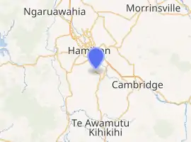
| Coordinates: 37.852237°S 175.305961°E | |
| Country | New Zealand |
| Region | Waikato Region |
| District | Waipa District |
| Population (2018 census) | |
| • Territorial | 159 |
| Time zone | UTC+12 (NZST) |
| • Summer (DST) | UTC+13 (NZDT) |
It is located just south of the Hamilton suburb of Glenview, west of the Waikato District town of Tamahere and north of the Waipa towns of Ōhaupō and Te Awamutu, on State Highway 3.
The area includes several farms on the flat between the Rukuhia Swamp and the Waikato River, and the Hamilton Airport industrial area.[1]
Rukuhia translates as gathered together, submerged or dived for.[1]
The Rukuhia School First World War Memorial was unveiled in June 1923, on the sixth anniversary of the Battle of Messines. It is a tribute to the 22 men from Rukuhia who served in World War I, including the nine who were killed or who died of wounds, and nine others who were wounded but survived. The memorial was rededicated on Armistice Day in 2003.[2]
The Rukuhia railway station was a station on the North Island Main Trunk in New Zealand,[3][4] established during the extension of the railway line in the 1870s.[5][6] Tests in 1981 found that the track deformed by about 12mm each time a train went over it, due to the peat swamp.[7]
Demographics
| Year | Pop. | ±% p.a. |
|---|---|---|
| 2006 | 1,170 | — |
| 2013 | 1,278 | +1.27% |
| 2018 | 1,479 | +2.96% |
| Source: [8] | ||
The statistical area of Lake Cameron, which includes Rukuhia but at 52 square kilometres is much larger, had a population of 1,479 at the 2018 New Zealand census, an increase of 201 people (15.7%) since the 2013 census, and an increase of 309 people (26.4%) since the 2006 census. There were 465 households. There were 804 males and 675 females, giving a sex ratio of 1.19 males per female. The median age was 36 years (compared with 37.4 years nationally), with 291 people (19.7%) aged under 15 years, 351 (23.7%) aged 15 to 29, 660 (44.6%) aged 30 to 64, and 177 (12.0%) aged 65 or older.
Ethnicities were 85.6% European/Pākehā, 10.1% Māori, 1.0% Pacific peoples, 8.9% Asian, and 2.0% other ethnicities (totals add to more than 100% since people could identify with multiple ethnicities).
The proportion of people born overseas was 21.1%, compared with 27.1% nationally.
Although some people objected to giving their religion, 48.1% had no religion, 38.3% were Christian, 2.4% were Hindu, 1.8% were Muslim, 0.4% were Buddhist and 2.0% had other religions.
Of those at least 15 years old, 336 (28.3%) people had a bachelor or higher degree, and 159 (13.4%) people had no formal qualifications. The median income was $37,100, compared with $31,800 nationally. The employment status of those at least 15 was that 636 (53.5%) people were employed full-time, 195 (16.4%) were part-time, and 24 (2.0%) were unemployed.[8]
Rukuhia village is in meshblocks 4012006 and 4012008, which had a population of 159 in 2018.[9]
Education
Rukuhia School is a co-educational state primary school for Year 1 to 8 students,[10] with a roll of 112 as of March 2020.[11] The school opened in 1907.[12]
References
- "Rukuhia". nzhistory.govt.nz. Ministry for Culture and Heritage.
- "Rukuhia school war memorial". nzhistory.govt.nz. Ministry for Culture and Heritage.
- New Zealand Railway and Tramway Atlas (First ed.). Quail Map Co. 1965. pp. 3 & 4.
- Pierre, Bill (1981). North Island Main Trunk. Wellington: A.H&A.W Reed. pp. 289–290. ISBN 0589013165.
- "Rapid progress with Hamilton to Ohaupo Railway Extension". paperspast.natlib.govt.nz (Vol XI, Issue 879). Waikato Times. 7 February 1878. p. 2.
- "Messrs Davys Bros, Rukuhia Sawmills and 2-mile horse tram" (Vol XLV, Issue 3648). Waikato Times. 19 November 1895. p. 2.
- "5.4 Railway Stabilisation through Peatlands" (PDF). nzgs.org. University of Auckland.
- "Statistical area 1 dataset for 2018 Census". Statistics New Zealand. March 2020. Lake Cameron (181600). 2018 Census place summary: Lake Cameron
- "Meshblock Electoral Populations 2020 for proposed boundaries data". Statistics New Zealand. April 2020. Meshblocks 4012006 and 4012008.
- Education Counts: Rukuhia School
- "Education Review Office Report". ero.govt.nz. Education Review Office.
- "100 years--1907-2007 : Rukuhia School Centennary (collection record)". WorldCat. Retrieved 1 November 2020.
