Ruokolahti
Ruokolahti (Swedish: Ruokolax) is a municipality of Finland, situated in south-eastern Finland, in the region of South Karelia. Neighbouring municipalities are Imatra, Lappeenranta, Taipalsaari, Puumala, Sulkava, Punkaharju, Parikkala and Rautjärvi. Ruokolahti covers an area of 1,219.85 square kilometres (470.99 sq mi) of which 23% is water.[1]
Ruokolahti
Ruokolax | |
|---|---|
Municipality | |
| Ruokolahden kunta Ruokolax kommun | |
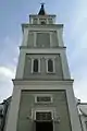
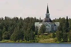 Church in Ruokolahti | |
 Coat of arms | |
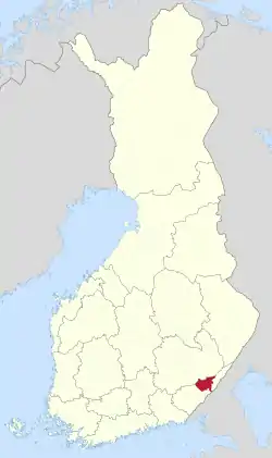 Location of Ruokolahti in Finland | |
| Coordinates: 61°17.5′N 028°49′E | |
| Country | |
| Region | South Karelia |
| Sub-region | Imatra sub-region |
| Charter | 1868 |
| Government | |
| • Municipal manager | Antti Pätilä |
| Area (2018-01-01)[1] | |
| • Total | 1,219.85 km2 (470.99 sq mi) |
| • Land | 943.50 km2 (364.29 sq mi) |
| • Water | 276.4 km2 (106.7 sq mi) |
| Area rank | 81st largest in Finland |
| Population (2020-07-31)[2] | |
| • Total | 4,996 |
| • Rank | 173rd largest in Finland |
| • Density | 5.3/km2 (14/sq mi) |
| Population by native language | |
| • Finnish | 98.8% (official) |
| • Swedish | 0.1% |
| • Others | 1.1% |
| Population by age | |
| • 0 to 14 | 13.6% |
| • 15 to 64 | 61.5% |
| • 65 or older | 24.9% |
| Time zone | UTC+02:00 (EET) |
| • Summer (DST) | UTC+03:00 (EEST) |
| Municipal tax rate[5] | 18.5% |
| Climate | Dfc |
| Website | www.ruokolahti.fi |
The municipality has 4,996 inhabitants (31 July 2020),[2] but the population is doubled in summer as holidaymakers occupy the 3,000 summer cottages in the region.[6]
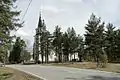
Ruokolahti is known for its natural environment, for example Kummakivi is a balancing rock located at 61° 29' 36.4596" N, 28° 25' 45.5016" E in Ruokolahti[7] and is protected.[8] In the west there is the Lake Saimaa and in the east there are hundreds of smaller lakes. The Salpausselkä ridges run through the area.[6]
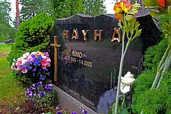
The famous sniper Simo Häyhä lived in Ruokolahti for 57 years after the 1939–40 Winter War.[9] He is buried there in the graveyard of Ruokolahti Church.
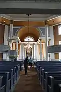
Gallery
References
- "Area of Finnish Municipalities 1.1.2018" (PDF). National Land Survey of Finland. Retrieved 30 January 2018.
- "Suomen virallinen tilasto (SVT): Väestön ennakkotilasto [verkkojulkaisu]. Heinäkuu 2020" (in Finnish). Statistics Finland. Retrieved 13 September 2020.
- "Population according to language and the number of foreigners and land area km2 by area as of 31 December 2008". Statistics Finland's PX-Web databases. Statistics Finland. Retrieved 29 March 2009.
- "Population according to age and gender by area as of 31 December 2008". Statistics Finland's PX-Web databases. Statistics Finland. Retrieved 28 April 2009.
- "List of municipal and parish tax rates in 2011". Tax Administration of Finland. 29 November 2010. Retrieved 13 March 2011.
- Hupponen, Paula (14 December 2003). "General Information". Discover Ruokolahti. Ruokolahti: Municipality of Ruokolahti. Archived from the original on 11 February 2010. Retrieved 15 February 2009. (Text from Discover Ruokolahti web site with a permission.)
- "Karrta Paikka" (in Finnish). National Land Survey of Finland. Retrieved 1 December 2013.
- Lehteinen, Markus. "Ruokolahden Kummakivi" (in Finnish). Retkipaikka. Retrieved 1 December 2013.
- "Tappouhkaukset ja pelko varjostivat sotalegenda Simo Häyhän elämää". Yle Uutiset (in Finnish). 2017-06-18. Retrieved 2020-05-09.
External links
![]() Media related to Ruokolahti at Wikimedia Commons
Media related to Ruokolahti at Wikimedia Commons
- Municipality of Ruokolahti – Official website
- Discover Ruokolahti – Information for tourists
| Municipalities |  | |
|---|---|---|
| Former municipalities |
| |
| Authority control |
|---|
