Rushford (CDP), New York
Rushford is a census-designated place comprising the central settlement in the town of Rushford, Allegany County, New York, United States. As of the 2010 census it had a population of 363,[1] out of a total population of 1,150 in the town.
Rushford, New York | |
|---|---|
 Rushford Location within the state of New York | |
| Coordinates: 42°23′31″N 78°15′12″W | |
| Country | United States |
| State | New York |
| County | Allegany |
| Town | Rushford |
| Area | |
| • Total | 0.5 sq mi (1.4 km2) |
| • Land | 0.5 sq mi (1.4 km2) |
| • Water | 0.0 sq mi (0.0 km2) |
| Elevation | 1,500 ft (500 m) |
| Population (2010) | |
| • Total | 363 |
| • Density | 670/sq mi (260/km2) |
| Time zone | UTC-5 (Eastern (EST)) |
| • Summer (DST) | UTC-4 (EDT) |
| ZIP code | 14777 |
| Area code(s) | 585 |
| FIPS code | 36-64155 |
| GNIS feature ID | 0963104 |
Geography
The Rushford CDP is located near the center of the town of Rushford, north of Caneadea Creek, a tributary of the Genesee River. New York State Route 243 bypasses the center of the community, forming the northeast edge of the CDP. It leads east 6 miles (10 km) to Route 19 in the Genesee River valley and northwest into Cattaraugus County.
According to the United States Census Bureau, the Rushford CDP has a total area of 0.54 square miles (1.4 km2), all land.[1]
References
- "Geographic Identifiers: 2010 Demographic Profile Data (G001): Rushford CDP, New York". U.S. Census Bureau, American Factfinder. Archived from the original on February 12, 2020. Retrieved June 28, 2013.
Municipalities and communities of Allegany County, New York, United States | ||
|---|---|---|
| Towns | 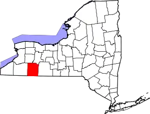 | |
| Villages | ||
| CDPs | ||
| Hamlets | ||
| Indian reservation | ||
| Footnotes | ‡This populated place also has portions in an adjacent county or counties | |
| ||
This article is issued from Wikipedia. The text is licensed under Creative Commons - Attribution - Sharealike. Additional terms may apply for the media files.