Rusthall Common
Rusthall Common is a 2.7-hectare (6.7-acre) geological Site of Special Scientific Interest in Rusthall, a suburb of Tunbridge Wells in Kent.[1][2] It is a Geological Conservation Review site.[3] It is owned by the Manor of Rusthall and managed by Tunbridge Wells Commons Conservators.[4]
| Site of Special Scientific Interest | |
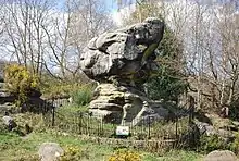 Toad Rock | |
| Area of Search | Kent |
|---|---|
| Grid reference | TQ 568 395[1] |
| Interest | Geological |
| Area | 2.7 hectares (6.7 acres)[1] |
| Notification | 1992[1] |
| Location map | Magic Map |
This Quaternary site is important for its examples of sandstone weathering, especially Toad Rock, which stands on a narrow base moulded by periglacial wind erosion.[5]
There is access to the site from Rusthall Road.
References
- "Designated Sites View: Rusthall Common". Sites of Special Scientific Interest. Natural England. Retrieved 25 February 2018.
- "Map of Rusthall Common". Sites of Special Scientific Interest. Natural England. Retrieved 25 February 2018.
- "Rusthall Common (Quaternary of South-East England)". Geological Conservation Review. Joint Nature Conservation Committee. Archived from the original on 2018-01-12. Retrieved 11 January 2018.
- "Rusthall Common". Explore Kent. Retrieved 25 February 2018.
- "Rusthall Common citation" (PDF). Sites of Special Scientific Interest. Natural England. Retrieved 25 February 2018.
| Wikimedia Commons has media related to Rusthall Common. |
This article is issued from Wikipedia. The text is licensed under Creative Commons - Attribution - Sharealike. Additional terms may apply for the media files.
