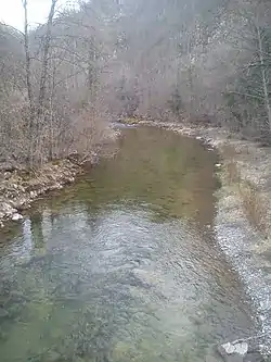
Rzav (Golija)
The Rzav (Serbian Cyrillic: Рзав) is a river in southwestern Serbia. The 62 km long left tributary to the Golijska Moravica river, it originates from two headstreams, the Veliki Rzav and the Mali Rzav. The river is sometimes referred to as the Golijski Rzav (Serbian Cyrillic: Голијски Рзав, "Rzav of Golija") to distinguish it from another Rzav river in Serbia, the Rzav of Zlatibor.
| Rzav | |
|---|---|
 Veliki Rzav, as seen from the simple suspension bridge in the village of Roge, February 2014 | |
| Native name | Рзав (Serbian) |
| Location | |
| Country | Serbia |
| Physical characteristics | |
| Source | |
| • location | Murtenica (Zlatibor, as the Veliki Rzav) mountain, west Serbia |
| Mouth | |
• location | Golijska Moravica river, near Arilje |
• coordinates | 43.7694°N 20.1010°E |
| Length | 62 km (39 mi) |
| Basin size | 575 km2 (222 sq mi) |
| Basin features | |
| Progression | Golijska Moravica→ West Morava→ Great Morava→ Danube→ Black Sea |
Mali Rzav
The Mali Rzav (Serbian Cyrillic: Мали Рзав, "Little Rzav") is the Rzav's shorter headstream. It originates from the northern slopes of the Mučanj mountain, near the village of Katići. Originally the river flows to the west, but at the village of Bjeluša it makes a large elbow turn, parallel to the even larger elbow turn of the Veliki Rzav. At the villages of Gornja Krušćica and Vranovina, the Mali Rzav straightens its course to the north and on the southern slopes of the Blagaja mountain meets the Veliki Rzav.
Veliki Rzav
The Veliki Rzav (Serbian Cyrillic: Велики Рзав, "Great Rzav") is the Rzav's longer headstream and sometimes it is referred to as just Rzav alongside its whole course. It originates from the southern slopes of the Murtenica mountain, southern extension of the Zlatibor mountain, in the northern part of the Stari Vlah region.
The Veliki Rzav originally flows eastward, next to the villages of Gornja Bela Reka and Donja Bela Reka (Serbian for upper white river and lower white river, referring to the river's clear water). At the village of Klekova the river sharply turns to the north, making a large elbow turn, beginning at the village of Velika, on the western slope of the Čigota mountain. Inside this elbow turn is the smaller curve of the Mali Rzav, and the two rivers get at one point less than 2 km apart. The Veliki Rzav receives from the left the Katušnica river and continues to curve to the north in the mountain region, between the villages of Razložina and Čičkovo, making another sharp elbow turn to the east, between the Lipovac and Gradina peaks, southeast of the town of Užice. After the village of Roge, the river continues on the southern slope of the Blagaja mountain, receiving the Mali Rzav from the right.
For the most part, the road follows the curvy river. There are 8 beaches along the river (Bosa Noga (Bare foot), Sonjine Oči (Sonja's eyes), Pogledi (Gazes)), but the river is known for its cold water. At the locality of Bojovića Kuk, the river carved a canyon. The fishing in the river is forbidden. There are several fishponds along the route, mostly for breeding trout.[1]
The spa of Visočka Banja is located on the river. The thermal water has 27 °C (81 °F). Formerly, the spa water was forming a pond of lukewarm water. The spa was recorded as health beneficial in 1936. In 1952, one of the visitors who claimed that the water helped his ailing wife, built the first, shallow spa pool. The pathways and wooden bridge were constructed in 1985. In 2012-2014 two additional, room-sized concrete pools were built, also by the former visitors. One pool has bottom filled with sand. Construction of the third, roofed pool followed, so as the paved road and new, pedestrian mountain pathway.[1]
The water comes from the underground lake, some 30,000 thousand years old. Water is beneficial for the rheumatic and cardiac illnesses, when properly used (being still in the water and no more than three times a day with total of 20 minutes only). Just outside of the complex is another water spring ("third water", the Rzav and the spa being the first two). It allegedly helps with the eye diseases. The intake for the spring was built in 1975. Local ecologists opted not to place garbage bins, instead all visitors take garbage back with them.[1]
Rzav
The remaining course under the name of the Rzav is less than 10 km long. It continues to the east as the natural extension of the Veliki Rzav around the Blagaja mountain, reaching the town of Arilje where it turns sharply for the last time, this time to the north, emptying into the Golijska Moravica.
The Rzav drains an area of 575 km², belongs to the Black Sea drainage area and it is not navigable.
References
- Saša Savović (26 July 2020). Занимљива Србија: Височка бања - Чудесна вода рађа се из камена [Intersting Serbia: Visočka Banja - Miraculous water is being born from stone]. Politika (in Serbian). pp. 20–21.
| Wikimedia Commons has media related to Rzav (Golijska Moravica). |