Zlatibor
Zlatibor (Serbian Cyrillic: Златибoр pronounced [zlǎtibɔːr]) is a mountainous region situated in the western part of Serbia.
| Zlatibor | |
|---|---|
| Златибор | |
 | |
| Highest point | |
| Elevation | 1,496 m (4,908 ft) |
| Coordinates | 43°38′53″N 19°40′44″E |
| Geography | |
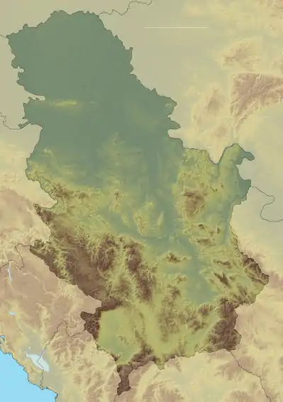 Zlatibor Location in Serbia | |
| Location | Western Serbia |
| Parent range | Dinaric Alps |
Among the most popular places in Serbia for tourism, Zlatibor's main attractions include health tourism, skiing, and hiking[1] and the longest panoramic gondola lift in the world.[2][3] Tornik ski resort is located in the area.
The largest city in the region is Užice—located at the foothills of the mountain—while most of the area belongs to the municipality of Čajetina. The town of Zlatibor has shifted over the years from a group of vacation homes to an urban location with diverse amenities. The The Zlatibor region is divided among two municipalities, Čajetina and Užice, while both lie within the Zlatibor District. The Belgrade-Bar railroad passes through Zlatibor.
History
In the Middle Ages, the region was known as Rujno, a župa that was part of Raška, a centre of the medieval Serbian state. The name Zlatibor came into the 18th century, but its etymology is uncertain. It probably stems from the Serbian words zlatni (golden) and bor (pine). Pinus sylvestris var. zlatiborica is a subspecies of pine originating from the mountain, and is endangered today.
A hill by the name of Cigla, located near the nearby village of Jablanica, still has some borderline markings of the Kingdom of Serbia, Austria-Hungary, and the Ottoman Empire.
World War II
In the late 1941, the mountain became a focal point of the treasure hunt, connected with the withdrawal of the Partisans from the collapsing free territory of the Republic of Užice. After taking Užice, the Partisans confiscated much paper and silver money. On 10 October 1941 they shipped two trucks to the mountain and buried the money. Another bulk, only silver, was taken with them during the withdrawal in the end of November and buried into the ground on Zlatibor. After the war, the official story by the Partisans was that all the money was later seized by the Germans and the Chetniks, but after the fall of Communism, different information surfaced.[4]
On 28 November 1941, Josip Broz Tito and Slobodan Penezić Krcun ordered for the silver to originally be transported to the Zlatibor villa of the Belgrade lawyer Aca Pavlović. There were 103 cases, 60 kg each, or 6 tons in total. It was masked as an ammunition. The treasure was then transported to the location of Borova Glava, where at the locality of Jokina Ćuprija part of it was buried, but the work wasn't finished due to the German offensive, so they tried to move the remaining part. As the transport by trucks wasn't an option due to the offensive, the Partisans were now carrying the crates on their backs. As they were chased by the Germans, the Partisans threw away the crates and the silver scattered over the meadows in the direction of the river Rzav, managing to keep only few bags of paper money.[4]
According to the report of the Chief of Staff, the Partisans lost half of the paper money during the withdrawal across the Zlatibor, while the silver coins were sloppily buried and then stolen by "some people". Both the Germans and the local population in the ensuing period searched and collected treasure on the mountain. Germans discovered the main vault left by the Partisans (1.8 million dinars at the time) in the search party organized on 3 December. They also collected most of the silver which was dispersed on the mountain.[4]
During the winter and summer of 1944, 47 Allied airmen were shot down over the mountain by the German anti-aircraft units. They were saved and hidden by the local Chetniks. The airmen were later secretly transported to the airstrip in Pranjani, some 75 km (47 mi) to the northeast, from where they were airlifted by the Allied forces within the scopes of the Operation Halyard.[5]
Geography
Zlatibor itself is located in the northern part of the Stari Vlah region, a historical border region between Raška, Herzegovina and Bosnia. It spreads over an area of 300 square kilometres (120 square miles), 43 km (27 mi) in length, southeast to northwest, and up to 37 km (23 mi) in width. Its highest peak, Tornik, has an elevation of 1,496 m. Zlatibor is situated between 43° 31' N, and 43° 51' N, and between 19° 28' E and 19° 56' E.
The southern and the eastern border of Zlatibor are natural – the rivers Uvac and Veliki Rzav. Villages of Mokra Gora, Semegnjevo and Jablanica mark its western border towards the Tara Mountain. Southern part of Zlatibor, extending towards the Zlatar (mountain) mountain, is referred to as Murtenica.[6]
Climate
The climate is humid continental (Köppen climate classification: Dfb).
| Climate data for Zlatibor, 1981-2010 | |||||||||||||
|---|---|---|---|---|---|---|---|---|---|---|---|---|---|
| Month | Jan | Feb | Mar | Apr | May | Jun | Jul | Aug | Sep | Oct | Nov | Dec | Year |
| Average high °C (°F) | 2.1 (35.8) |
3.3 (37.9) |
7.5 (45.5) |
12.4 (54.3) |
17.6 (63.7) |
20.8 (69.4) |
23.1 (73.6) |
23.3 (73.9) |
18.6 (65.5) |
14.0 (57.2) |
7.8 (46.0) |
2.6 (36.7) |
12.8 (55.0) |
| Daily mean °C (°F) | −2.1 (28.2) |
−1.3 (29.7) |
2.4 (36.3) |
7.2 (45.0) |
12.3 (54.1) |
15.4 (59.7) |
17.2 (63.0) |
17.5 (63.5) |
13.1 (55.6) |
8.8 (47.8) |
3.2 (37.8) |
−1.2 (29.8) |
7.7 (45.9) |
| Average low °C (°F) | −5.2 (22.6) |
−4.7 (23.5) |
−1.2 (29.8) |
3.2 (37.8) |
7.9 (46.2) |
10.8 (51.4) |
12.7 (54.9) |
12.9 (55.2) |
9.0 (48.2) |
5.1 (41.2) |
0.1 (32.2) |
−4.0 (24.8) |
3.9 (39.0) |
| Average precipitation mm (inches) | 65.4 (2.57) |
68.5 (2.70) |
73.4 (2.89) |
79.0 (3.11) |
94.4 (3.72) |
110.2 (4.34) |
96.3 (3.79) |
78.8 (3.10) |
98.3 (3.87) |
78.2 (3.08) |
92.3 (3.63) |
82.6 (3.25) |
1,017.3 (40.05) |
| Mean monthly sunshine hours | 92.1 | 105.7 | 141.9 | 161.4 | 210.1 | 229.8 | 272.9 | 259.4 | 196.1 | 160.6 | 108.1 | 76.4 | 2,014.5 |
| Source: Republic Hydrometeorological Service of Serbia[7] | |||||||||||||
Tourism
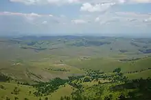
Situated at an elevation of just over 1,000 metres, Zlatibor is a climatic resort, characterized by a cool alpine climate, clean air, long periods of sunshine during the summer and a heavy snow cover in winter. Tourist facilities include modern hotels, holiday centers and cottages, sports grounds and skiing tracks.
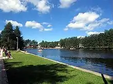
Tourist era on Zlatibor officially began on 20 August 1893, when the King of Serbia Aleksandar Obrenović decided to establish a health resort on an initiative from the local hosts. To his honor, a fountain was erected on the place where he had lunch, and named Kraljeva Voda ("King's water").[1] The fountain was accompanied by the small artificial Zlatibor Lake, formed in 1947. It was built by damming the Obudovica river during one of the Youth work actions, on the project by engineer Miladin Pećinar.[8]
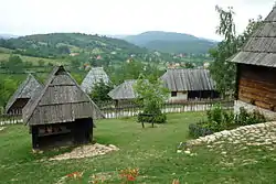
In 1945 the settlement was renamed to Partizanske Vode after Yugoslav Partisans, and in 1991 the town received the current name Zlatibor. The area is a location of numerous hotels, villas, restaurants, open swimming pools and other sports facilities. Eventually, residents of surrounding villages of Sirogojno, Gostilje, Jablanica, Rožanstvo, Ljubiš, Tripkova and the town of Čajetina opened their homes to tourists and built other facilities.[1]
The lake was completely emptied in April and May 2020 for renovation, which includes the nearby Kraljev Trg ("King's Square"). The lakebed was washed and cleaned, the diversion channel will be built around it to conduct dirty water during the rainfall while the multi-purpose floating stage will be placed on the lake.[8]
Since 2005, an annual "Village Multisport Event" (Seoski višeboj) is held in the village of Jablanica. Event consists of performing various old tasks (lighting of the evergreen-produced tar kilns, dancing and singing folk songs, logs sawing, horse races, stone throwing, climbing the poles and, the main event, ox-powered dragging of tree trunks down the mountain).[9] At the Vodice locality, 14 km (8.7 mi) from Zlatibor town, a Western-style resort and theme park "El Paso City" was opened in May 2020. It covers 6 ha (15 acres), including a hotel but also the bungalows in the shape of tents, caravans and wagons, horse stable and Indian village named after Sitting Bull. River which flows through the complex divides it in Western section and a Serbian one across it, which includes church and hamlet.[10]
In the mid-19th century, the business of trade caravans blossomed in the Užice and Zlatibor area. Merchant heading the caravan was called kiridžija (plural kiridžije). The caravans had 15 to 20 horses and Zlatibor merchants became famous for their work. Photographer Ilija Lazić took a photo of kiridžija Todor Udovičić Gajević (by some sources Todor Gajović) in the early 20th century, which became iconic. Lazić named it "Zlatibor's fast train" and used it for postcards. Real railroad reached Užice in 1912, and number of caravan merchants began to dwindle. With introduction of motor vehicles, kiridžije disappeared by 1950. Based on the photo, Miladin Lekić, self-taught sculptor, carved wooden sculptures of Gajević (generically referred to as Era, name for the inhabitant of southwest Serbia) and his horse, 2.6 m (8 ft 6 in) and 2.5 m (8 ft 2 in) tall, respectively. They were made of wood from Stubla: Gajević from oak, and horse from elm wood. The sculptures were placed in the center of King's Square in 2013, marking 120 years of organized tourism in Zlatibor. During the 2020 reconstruction, the sculptures were moved to the starting section of the promenade. The sculptural group is called "Zlatibor's fast train", after the photo.[11]
After 3 days of trial operation, on 14 January 2021, the longest panoramic gondola lift in the world became operational. It connects the center of Zlatibor with the Tornik peak, via the Ribnica Lake. It is 8.95 km (5.56 mi) long, has 55 gondolas with 10 seats each and is designed to transport 600 passengers in one hour.[12][13]
Protection
The process began in January 2016 and in October 2017, the government placed part of the mountain under protection as a Nature Park Zlatibor. The land within the "protected area of exceptional importance" (IUCN Category I) is 56% privately owned and covers the villages of Semegnjevo, Jablanica, Stublo, Dobroselica, Ljubiš and Gostilje. The settled area is in the lowest, third level of protection while the first level of protection occupies 4,69% of the entire area, or 1,968.89 ha (4,865.2 acres). Within the park there are four regions: Viogor, Black Rzav, Uvac Gorge and Griža Gorge. There are also previously protected areas: strict natural reserve "Park Forest" (12.54 ha (31.0 acres)) and natural monuments "Lira black pine" (near Nova Varoš) and "Three black pines - Dobroselica" (near Čajetina).[14] The total area of the park is 41.923 ha (103.59 acres).[15]
There are 1,044 species of plants in the park. The prevailing fauna consists of the autochthonous black pine forests and the mixed forests of black and Scots pine, which are categorized as a priority habitats by the Natura 2000. There are 18 species of amphibians and reptiles, 154 species of birds (42% of all bird species recorded in Serbia) and 38 species of mammals (40%).[14] With the gradual return of wolves and bears in the 21st century, the tracking of the animals which began in 2017 on the Golija mountain, showed that the Zlatibor area is a main transit area for brown bears, which passed through here to the south and southeast areas, including Tara, Šargan, Mokra Gora, Golija, Uvac and Zlatar. 2019 surveys showed that a permanent population of brown bear settled at Zlatibor itself.[16]
The park includes three cultural monuments and numerous objects of architectural legacy.[14]
The park is bounded by the Uvac river on the south, border with Bosnia and Herzegovina on the west, mountains of Mokra Gora, Semegnjevo and Grude on the north and the mountain of Murtenica and Katušnica river on the east. Ribnica Lake and Čigota massif are within the park, while the towns of Čajetina and Zlatibor remain outside.[15]
See also
- Ponikve Airport (nearby airport)
- Tornik ski resort
References
- "Zlatibor Pride Anniversary - 120 Years of Tourism". Tourist Organization of Zlatibor. Retrieved 2016-01-19.
- "Posle pet godina, proradila panoramska zlatiborska gondola, najduža na svetu". N1 (in Serbian). 2021-01-11. Retrieved 2021-01-13.
- "Na Zlatiboru proradila najduža panoramska gondola na svetu". www.gradnja.rs (in Serbian). 2021-01-11. Retrieved 2021-01-13.
- Miloš Timotijević (7 February 2020). Злато у окупираној Србији 1941, део 3 (изводи из књиге Злато четника и партизана - деконструкција једног мита [Gold in occupied Serbia in 1941, part III (excerpts from the book Gold of the Chetniks and the Partisans - deconstruction of the myth]. Politika (in Serbian). p. 21.
- Branko Pejović (14 August 2020). "Savezničke pilote spasili, slomljenih krila ostali" [They saves Allied pilots, but remained with broken wings]. Politika (in Serbian).
- Olga Savić. "Geografske odlike Užičkog područja: Reljef" (PDF) (in Serbian). Grad Užice. Retrieved 2016-01-19.
- "SREDNJE MESEČNE, GODIŠNJE I EKSTREMNE VREDNOSTI 1981 - 2010". October 2017.
- Branko Pejović (30 April – 1 May 2020). Језеро без воде у центру Златибора [Lake in the center of Zlatibor without water]. Politika (in Serbian). p. 28.
- Branko Pejović (19 June 2020). "Jablanički višeboj odoleva i pandemiji" [Jablanica multi event resists the pandemic]. Politika (in Serbian). p. 13.
- Branko Pejović (16 May 2020). На Златибору отворен каубојски град [Cowboy city opened on Zlatibor]. Politika (in Serbian).
- Branko Pejović (14 December 2020). ""Brzi voz" na novom peronu" ["Fast train" on new platform]. Politika (in Serbian).
- Branko Pejović (12 January 2021). У ужичком крају снег и до колена [In some parts of the Užice region, snow high up to the knees]. Politika (in Serbian). p. 12.
- "Puštena u rad gondola na Zlatiboru, uz Vučića, himnu i veliki broj građana" [Zlatibor's gondola opened, with participation of Vučić, anthem and large number of citizens] (in Serbian). N1. 14 January 2021.
- Slavica Stuparušić (16 October 2017), "Još dva parka prirode na mapi Srbije" [Two more nature parks on the map of Serbia], Politika (in Serbian), p. 08
- Branko Pejović (19 October 2017), "Park prirode "Zlatibor" neće zaustaviti gradnju gondola" [Nature Park Zlatibor will not stop the construction of the cable car], Politika (in Serbian), pp. 01 & 16
- Slavica Stuparušić (4 January 2019). Све више медведа и вукова у нашим шумама [Growing number of bears and wolves in our forests]. Politika (in Serbian). p. 8.
External links
| Wikivoyage has a travel guide for Zlatibor. |
- Zlatibor in words and pictures Zlatibor.com
- Парк природе Златибор
| Wikimedia Commons has media related to Zlatibor. |
|  | |
(*) indicates location within Kosovo | ||