Sæbø, Møre og Romsdal
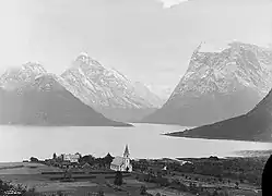
Sæbø is a village in the municipality of Ørsta, Møre og Romsdal, Norway. The village is located along the Hjørundfjorden, at the eastern end of the Bondalen valley, through which it connects to the town of Ørsta, the administrative centre of the municipality, via Norwegian County Road 655 (Fv655).
Sæbø | |
|---|---|
Village | |
 View of Sæbø | |
 Sæbø Location in Møre og Romsdal  Sæbø Sæbø (Norway) | |
| Coordinates: 62.2076°N 6.4759°E | |
| Country | Norway |
| Region | Western Norway |
| County | Møre og Romsdal |
| District | Sunnmøre |
| Municipality | Ørsta |
| Elevation | 3 m (10 ft) |
| Time zone | UTC+01:00 (CET) |
| • Summer (DST) | UTC+02:00 (CEST) |
| Post Code | 6165 Sæbø |
Sæbø is about 5 kilometres (3.1 mi) north of the mountain Skårasalen. The village of Store-Standal lies about 6 kilometres (3.7 mi) to the north and the villages of Leira and Bjørke lie about 11 kilometres (6.8 mi) to the south. The village of Urke is nearly due east, on the opposite side of Hjørundfjorden, on the north shore of the Norangsfjorden arm; the two villages are connected by ferry, which serves as a link between the eastern and western sections of Fv655.
Sæbø was the administrative centre of the former municipality of Hjørundfjord, which was incorporated into Ørsta in 1964.
