Sadiya
Sadiya (xôdiya, meaning "land of rising sun") is a town in Tinsukia district, Assam, India and was the third capital of Chutia Kingdom established by the second Sutiya ruler Ratnadhwajpal in 1248 and remained as the capital till 1524.[1] Extensive remains of buildings and fortifications built during the rule of the Chutias near Sadiya still point to the importance of the region in the past. Historically Sadiya included the entire districts of Lakhimpur, Dhemaji and Tinsukia. It was the center of development of the Eastern form of Prakrit during both the Chutia and Ahom periods, which later gave rise to the modern form of Assamese.[2] Its stands on a grassy plain, almost surrounded by forested Himalayan mountains, on the right bank of Lohit River which is locally (but erroneously) considered the main stream of the Brahmaputra river. Sadiya is famous for a flower named satphul (the word means "blessing" or a "desert flower"), which is much like Jasmine.
Sadiya
Sadia | |
|---|---|
town | |
| Nickname(s): Starting point of Assam | |
 Sadiya Location in Assam, India  Sadiya Sadiya (India) | |
| Coordinates: 27.83°N 95.67°E | |
| Country | |
| State | Assam |
| District | Tinsukia |
| Elevation | 123 m (404 ft) |
| Languages | |
| • Official | Assamese |
| Time zone | UTC+5:30 (IST) |
| Vehicle registration | AS 23 |
Etymology
The word "Sadiya" is derived from the Deori-Chutia language and it stands for "land of rising sun". "Sa/Xa" means "Sun", "Di" meaning "water" and "Ya" meaning "land". There is a sloka from the 14th century which shows that the region had a very ancient origin. It reads,
“Sadiya Korjaku-Desha Chutika-Bansha Bhirmuka
Dhatu Dravya Tu Lebhe Na Hatwa Janpadanaya”— Har-Gauri-Sambaad (written in the 14th century and incorporated in the Deodhai Buranji)
According to another source, the Gauda ruler possibly Keshav Sen made friends with the Chutia king Ratnadhwajpal (Gaurinarayan) who sent one of his sons to that country for education. Unfortunately, the Chutia Prince died there and the corpse was sent to Gaurinarayan. At the time of the arrival of the corpse, Gaurinarayan was engaged in building a new city. He named the city Sadiya (sa "corpse", diya "given").[3]
History
Early history
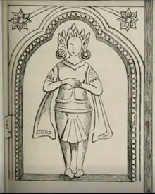
According to mythology, Sadiya was the capital of the legendary king Bhirmuko which was Sanskritised to Bhismak (whom the Chutiyas considers themselves as descendants of), but archeological evidence shows that this place became a capital only during the 7th–8th century.[4] There are ruins of an old city known locally as Bhismaknagar which was probably built by the earlier Chutia kings. Sadiya was later rebuilt by Gaurinarayan, the second ruler of the medieval greater Chutia dynasty during the mid 13th century and remained as the capital till the 16th century.
British period
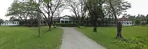
Sadiya was the extreme north-east frontier station of British Raj, in the Lakhimpur district of Eastern Bengal and Assam regions. On the opposite bank is a railway station that used to connect with the Assam-Bengal line of that era. Sadiya had been garrisoned by detachments of native infantry and military police, and was the base of a chain of outposts. There had a bazaar, to which the hill-men beyond the frontier—Mishmis, Abors, and Khamtis—used to bring down rubber, wax, ivory, and musk, to barter for Cotton cloth, salt and metal goods. In 1943-44 there was a United States Army Air Force (USAAF) field at Sadiya which hosted the 89th Fighter Squadron of the 80th Group, headquartered at Nagaghuli, now Chabua Air Base of the Indian Air Force. Sadiya today serves as one of the district headquarters for Indian Red Cross.
In 1882 Francis Jack Needham was appointed Assistant Political Agent for the British authorities after having served in the region as an assistant Superintendent of Police since 1876. He finally retired from service in 1905 after spending his life exploring above the Brahmaputra river and writing a treatise on the grammar of Miri, Singpho, and Khamti languages. He was awarded the Gill memorial medal in 1887 and made a fellow of The Royal Geographical Society in 1889. His main purpose in life was exploration partly in order to try and discover the source of the Brahmaputra river. His award of the Gill memorial Medal and F.R.G.S. was for penetrating into the Zanjul Valley and into Tibet from Assam. Another name for Sadiya was Sindhu khetra.
Architecture and ruins
The entire area of Sadiya was a well developed city in the medieval times. The ruins like Bhismaknagar, Rukmininagar, Tamreswari temple, Shiva temple, Pratima garh, Bura-buri temple built during the Chutia period.
Tamreswari(Kechai-Khati) Temple
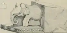
This was the most notable among the temples built by Chutia kings. The name "Tamreswari" was given as the roof of the temple was made out of copper. As per the Kalika Purana, the main temple was octagonal in shape surrounded by eight dwarapals in eight directions. When the Britishers visited the temple complex, the main temples has disappeared and only a small square structure remained. The wall and doors of the temple were well designed with beautiful works. There were two giant elephant sculptures with silver tusks at the main door of the complex. The walls were made without any mortar and instead used iron dowels and brackets. The whole temple was surrounded with brick walls and on the western wall there was a place for human sacrifice.[5] Although the temple is now completely submerged under marshy lands due to silt deposition in 1959, previous studies show that the main statues of the temple were built of sandstone and granite.
The stone inscription found in the temple reads,[6]
“Shiv-Charan-Prasadat Vridharajatan
Ya-Sri-srimata-Mukta Dharmanarayana
Shri shrimati Digaravasini Ichtaka
Di-Virchit-Prakara-Nivaddha
Krit Agrahainike Saka 1364”— Tamresari Wall inscription
The inscription describes that the walls of the temple have been built by the son Mukta Dharmanarayan of the old king(name not specified) in the Saka year 1364(1442 AD). The temple is said to be dedicated to the goddess Digarabaxini(Kechai-khati).
The roof of the Tamresari temple was originally sheeted with copper as mentioned in the Changrung Phukan Buranji(1711 AD), from which the name is derived. In 1848, when Dalton visited the site, he found a stone structure, but the copper roof was already removed. As per T.Block who visited the site in 1905, this square structure in the corner cannot have been the main building inside the complex and the brick wall evidently enclosed some sort of a grand temple in the center which has disappeared with time. According to S.F. Hannay, the temple complex was as near as possible square with the doorway to the west. There was a substantial brick wall, about 4.5 feet thick rising to the height of 8 feet, on the foundation of rudely cut blocks of sandstone. The entrance of the complex was on the west face, where there had been a stone enclosure and door. The ruins of the gateway which remains include the lintel carved on the edge in a chain of lotus flowers, some ornamented small pillars and an elephant statue. The three blocks forming the doorway, each of 7.5 feet long and 2 feet by 18 inches in girth, along with the blocks of the projecting wall, were reddish porphyritic granite of an adamantine hardness. There was another stone gateway at the southeast corner leading to the stream, in the bed of which are several carved and plain blocks of granite and sandstone.[7] According to Debala Mitra(1956), the temple was originally Chaturayatana, i.e. having four shrines, built of sandstone and granite and located in the south-east section of the rectangular brick enclosure, prakara roughly measuring 208 ft by 130 ft. The compound wall was 4 feet wide and 8 feet tall and had a stone gateway on the eastern side. In the floods of 1959, due to deposit of silt in the banks of Paya river the structure was completely submerged in the waters.[8]
Bura-Buri(Gira-Girasi) Than
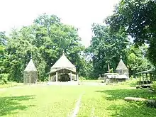
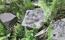
The Bura-Buri Than (temple) is another important temple built by the Chutia kings. It was dedicated to Shiva-parvati locally known as Gira-Girasi in the Chutia language. Although the structure has fallen due to natural calamities, the base still remains intact upon which a new temple has been built. The foundation is an octagonal shaped base made of stone with each edge spanning 3.4 meters in length. The temple was built using granite stone and fixed using iron dowels and brackets similar to the ones used in Malini Than and Tamreswari temple. The temple was surrounded by a wall built using bricks of 18–25 cm length and 12–17 cm breadth.[9]
Bhismaknagar Fort
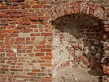
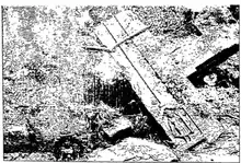
The Bhismaknagar Fort located in Roing is an important monument built by Chutia kings with the walls of the fort spread over 10 sq. km. A brick with the name Lakshminarayan indicates that the fort was repaired during the 15th century. The Bhismaknagar central complex extended over an area of 1860 square meters and displays three halls, six ingresses and two extension rooms. There is also a 2 meters high stone wall inside the complex. The architecture of the fort displays medieval culture. While quarrying in the fort, enormous pieces of work of art like potteries, terracotta figurines, terracotta plaques and decorative tiles were recovered.
Fabricated from the burnt bricks gave this fort an impressive and remarkable top view and thus explores the dexterity of people of ancient era. This fort can still be signified as an astonishing work of art.
The city is spread over an area of 10 square km. It is surrounded by a wall 4.5 meters high and 6 meters wide made using granite stone(6-9 courses)[10] and bricks on the east, west and south directions. In the north, the Mishmi hills provided a natural barrier. Although very less excavation has been carried out by the Arunachal government, preliminary excavations have revealed three tanks and two gates in the eastern and western directions.[11]
The Bhismaknagar central complex extended over an area of 1860 square meters and displays three halls, six ingresses and two extension rooms. There is also a 2 meters high stone wall inside the complex. The architecture of the fort displays the medieval culture. While quarrying the fort the enormous pieces of work of art like potteries, terracotta figurines, terracotta plaques and decorative tiles were preserved.
Rukmini Nagar
In the hills north of Roing lie scattered some old brick structures, mainly betweeh the Chidu and Chimri villages situated at an altitude of about 305 m. The local people, the Idus, were desirous of giving an Idu word to the name, and hence it came to be called Rukmini Nati (nati—the Idu word for bricks). An exploration-cum-excavation work, undertaken by the Research Department of the Government of Arunachal Pradesh, to study the ruins, has thrown some light on the antiquities. In course of the progress of work, which continued from January 1973 to April 1974, excavation of two mounds at Chimri, II km from Roing, unearthed two rooms, 10x10 m and 10x12 m respectively built on a slope, at a distance of 14 m from each other. The contents dug out from inside the walls of the rooms were of river-borne materials, a fact which suggests that they were destroyed by floods. The potsherds resembling those of Bhismaknagar in shape, fabric and technique that were unearthed bear ample evidence to the extension to this area of the same culture as of Bhismaknagar. The other archaeological sites in this area are located (I) near Chidu Inspection Bungalow, (2) at Cheko Nati between Chidu and Chimri and (3) in the hills north of Chimri. No relics, however, could be found at the first two sites, although potsherds at Chidu and brick walls, steps, etc. at Cheko Nati were reported to have been seen earlier. The third site north of Chimri is situated at a high altitude of about 610 m. Not a single brick found there was in alignment, and everything seemed destroyed. The situation of all the four sites on a hilly terrain suitable for defence indicate that they are parts of a single complex representing a fort which extended from Chidu to Chimri. It is probable that the main centre of this complex was at Cheko Nati. Another archaeological site called Duku Limbo is on the left bank of the Dibang at'the foot of Elopa hill. The brickbats found at this site suggest that the Brismaknagar culture had extended upto this point.[12]
Tezu Fort
An old Mud Fort in the Tindolong area, six km from Tezu, was explored in 1972. It falls on the main road from Sadiya to Tezu. The area of the fort, enclosed by earthen ramparts—365.76 m X 350.52 m, is square in shape. The rampart is eight ft high, and equally broad at the top with sloping sides. On both the -inner and outer sides of the rampart run two ditches about 6 m wide. There is a prominent mound, circular in shape (diameter 30.48 m approximately) and about 3 m in height, almost at the centre of the enclosure. The mound appears to be a cavalier for lookout purposes. Some potsherds found at this site are too fragmentary to bear any conclusive evidence. It may, however, be assumed that the Mud Fort linked by the route from Bhismaknagar to Parshuram Kund was probably associated with the early culture that flourished in and around Sadiya and Bhismaknagar.[13]
The complex seems to represent a defensive mud-fort or redoubt of a modest dimension unlike the fortified city of Bhismakanagara. It was suitable for a small band of soldiers to maintain vigilance against the enemies from their hide-outs inside jungle especially in guerilla warfare, the normal practice in the region. Scarp and counter-scarp provided by the rampart and ditches immensely strengthened the defence in the toppgraphy of the country. Strategic considerations are palpable from the situation of the fort on principal route from Sadiya and Bhismaknagar to Parshuram Kund facing the Lohit river, perhaps to keep watch on the enemy from its left bank around Chowkham and hence the position of the mound meant for this purpose nearer the river. The fort has been assigned roughly to a period about the 14th-15th century.[14]
Geography
Sadiya is located at 27.83°N 95.67°E.[15] It has an average elevation of 123 m (404 ft). It is the only area of Assam where the newly described subspecies of hoolock gibbon, which is known as Mishmi Hills hoolock H. h. mishmiensis occurs.[16]
Politics
Sadiya is part of Lakhimpur (Lok Sabha constituency). Name of the assembly constituency is 126-Sadiya LAC.
Sadiya is one of the three Sub-Divisions of Tinsukia District. Chapakhowa is the centre of Sadiya.[17]
See also
References
- (Col. Ved Prakash:912)
- Yasmin Saikia, Assam and India: Fragmented Memories, p.6
- (Prakash 2007:267)
- Bhismaknagar is dated to the 8th century.
- "Sadiya - Tourism, History, Culture and other facts". Retrieved 12 June 2015.
- Sircar,D.C,Journal of Ancient Indian History, p. 21.
- Hanney, S.F. Journal of the Asiatic Soceity of Bengal p. 468.
- Religious history of Arunachal Pradesh by Byomkesh Tripathi
- Baruah, Swarnalata. Chutia Jaatir Buranji. 2007, p. 433.
- Gait, Edward. A history of Assam(2nd Edition). 1962, p. 16.
- Raikar, Yashawant. Archeology in Arunachal Pradesh. 1980, p. 19.
- Lohit District
- Lohit District
- Chattopadhyay, S., History and archaeology of Arunachal Pradesh, p. 71
- Falling Rain Genomics, Inc - Sadiya
- .A. U. Choudhury (2013). Description of a new subspecies of hoolock gibbon Hoolock hoolock from North East India. The Newsletter & Journal of the Rhino Foundation for nat. in NE India 9: 49–59.
- "List of Parliamentary & Assembly Constituencies" (PDF). Assam. Election Commission of India. Archived from the original (PDF) on 4 May 2006. Retrieved 6 October 2008.
 This article incorporates text from a publication now in the public domain: Chisholm, Hugh, ed. (1911). "Sadiya". Encyclopædia Britannica. 23 (11th ed.). Cambridge University Press. p. 993.