Saint-François-de-l'Île-d'Orléans
Saint-François-de-l'Île-d'Orléans is a municipality in the Capitale-Nationale region of Quebec, Canada, part of the L'Île-d'Orléans Regional County Municipality. The village is situated on the north-eastern tip of Orléans Island, and the municipality also includes the Madame and Ruau Islands, part of the Montmagny Archipelago.
Saint-François-de-l'Île-d'Orléans | |
|---|---|
.jpg.webp) | |
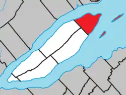 Location within L'Île-d'Orléans RCM. | |
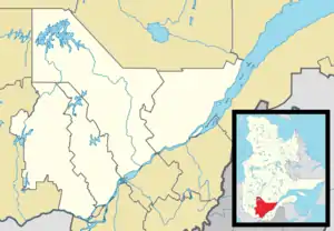 Saint-François-de-l'Île-d'Orléans Location in central Quebec. | |
| Coordinates: 47°00′N 70°49′W[1] | |
| Country | |
| Province | |
| Region | Capitale-Nationale |
| RCM | L'Île-d'Orléans |
| Settled | 1670s |
| Constituted | July 1, 1855 |
| Government | |
| • Mayor | Lina Labbé |
| • Federal riding | Montmorency—Charlevoix —Haute-Côte-Nord |
| • Prov. riding | Charlevoix–Côte-de-Beaupré |
| Area | |
| • Total | 102.80 km2 (39.69 sq mi) |
| • Land | 29.21 km2 (11.28 sq mi) |
| Population | |
| • Total | 527 |
| • Density | 18.0/km2 (47/sq mi) |
| • Pop 2006-2011 | |
| • Dwellings | 359 |
| Time zone | UTC−5 (EST) |
| • Summer (DST) | UTC−4 (EDT) |
| Postal code(s) | G0A 3S0 |
| Area code(s) | 418 and 581 |
| Highways | |
| Website | www |
Prior to December 20, 2003 it was known simply as Saint-François.[4]
History
The Parish of Saint-François-de-Sales was founded in 1679, named after Francis de Sales (1567-1622) and calling to mind Francois Berthelot, Comte de Jouy and de Saint-Laurent, representative of Paris in parliament and Seigneur of Île d'Orléans (1675) at the time the parish was established. It was also known as just Saint-François, and maps of the seventeenth and eighteenth centuries would show either one or the other form. In 1845, the Parish Municipality of Saint-François-Isle-d'Orléans was formed, but abolished in 1847 when it became part of the County Municipality. In 1852, the local post office opened. In 1855, the parish municipality was reestablished.[1]
In 2003, the Parish Municipality of Saint-François became the Municipality of Saint-François-de-l'Île-d'Orléans.[1]
Demographics
Population
| Canada census – Saint-François-de-l'Île-d'Orléans, Quebec community profile | |||
|---|---|---|---|
| 2011 | 2006 | ||
| Population: | 527 (-8.0% from 2006) | 573 (+17.2% from 2001) | |
| Land area: | 29.21 km2 (11.28 sq mi) | 29.21 km2 (11.28 sq mi) | |
| Population density: | 18.0/km2 (47/sq mi) | 19.6/km2 (51/sq mi) | |
| Median age: | 52.9 (M: 51.6, F: 54.1) | 49.2 (M: 49.2, F: 49.2) | |
| Total private dwellings: | 359 | 368 | |
| Median household income: | $.N/A | $51,180 | |
| Notes: 2011 income data for this area has been suppressed for data quality or confidentiality reasons. – References: 2011[3] 2006[5] earlier[6] | |||
|
|
|
Language
| Canada Census Mother Tongue - Saint-François-de-l'Île-d'Orléans, Quebec[7] | ||||||||||||||||||
|---|---|---|---|---|---|---|---|---|---|---|---|---|---|---|---|---|---|---|
| Census | Total | French |
English |
French & English |
Other | |||||||||||||
| Year | Responses | Count | Trend | Pop % | Count | Trend | Pop % | Count | Trend | Pop % | Count | Trend | Pop % | |||||
2011 |
530 |
505 | 95.28% | 15 | 2.83% | 0 | 0.00% | 10 | 1.89% | |||||||||
2006 |
575 |
550 | 95.65% | 15 | 2.61% | 0 | 0.00% | 10 | 1.74% | |||||||||
2001 |
490 |
490 | 100.00% | 0 | 0.00% | 0 | 0.00% | 0 | 0.00% | |||||||||
1996 |
490 |
490 | n/a | 100.00% | 0 | n/a | 0.00% | 0 | n/a | 0.00% | 0 | n/a | 0.00% | |||||
References
- "Saint-François-de-l'Île-d'Orléans (Municipalité)" (in French). Commission de toponymie du Québec. Retrieved 2009-10-27.
- Geographic code 20005 in the official Répertoire des municipalités (in French)
- "2011 Community Profiles". 2011 Canadian Census. Statistics Canada. July 5, 2013. Retrieved 2014-04-18.
- "Archived copy" (PDF). Archived from the original (PDF) on 2004-02-05. Retrieved 2012-03-25.CS1 maint: archived copy as title (link)
- "2006 Community Profiles". 2006 Canadian Census. Statistics Canada. March 30, 2011. Retrieved 2014-04-18.
- "2001 Community Profiles". 2001 Canadian Census. Statistics Canada. February 17, 2012.
- Statistics Canada: 1996, 2001, 2006, 2011 census
External links
Adjacent Municipal Subdivisions | |
|---|---|
| Municipalities | |
|---|---|
| Parishes | |
| Villages | |
| |
| Authority control |
|---|