Saint-Pierre, Réunion
Saint Pierre (French pronunciation: [sɛ̃.pjɛʁ]) is the third-largest commune in the French overseas department and region of Réunion. Located on the southwest side of the island, it is the capital of the French Southern and Antarctic Lands. It developed from a port built from 1854 to 1882, which was used for the trade between Asia and Europe. Today, it features 400 sites for fishing and pleasure boats, while most of the commercial traffic moved north to Le Port.
Saint Pierre | |
|---|---|
Subprefecture and commune | |
 An aerial view of part of Saint-Pierre and its port | |
 Coat of arms | |
| Motto(s): Fortis fortuna fortior (Latin: 'Courage is stronger than fortune') | |
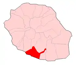 | |
Location of Saint Pierre 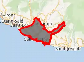
| |
| Coordinates: 21°20′31″S 55°28′40″E | |
| Country | France |
| Overseas region and department | Réunion |
| Arrondissement | Saint-Pierre |
| Canton | Saint-Pierre-1, 2 and 3 |
| Intercommunality | Villes solidaires |
| Government | |
| • Mayor (2020–2026) | Michel Fontaine[1] (LR) |
| Area 1 | 95.99 km2 (37.06 sq mi) |
| Population (2017-01-01)[2] | 84,212 |
| • Density | 880/km2 (2,300/sq mi) |
| Time zone | UTC+04:00 |
| INSEE/Postal code | 97416 /97410 |
| Elevation | 0–1,642 m (0–5,387 ft) (avg. 19 m or 62 ft) |
| 1 French Land Register data, which excludes lakes, ponds, glaciers > 1 km2 (0.386 sq mi or 247 acres) and river estuaries. | |
Climate
| Climate data for St.-Pierre | |||||||||||||
|---|---|---|---|---|---|---|---|---|---|---|---|---|---|
| Month | Jan | Feb | Mar | Apr | May | Jun | Jul | Aug | Sep | Oct | Nov | Dec | Year |
| Average high °C (°F) | 29 (85) |
29 (85) |
29 (84) |
28 (82) |
26 (79) |
24 (76) |
24 (75) |
23 (74) |
24 (76) |
26 (79) |
28 (82) |
28 (83) |
27 (80) |
| Average low °C (°F) | 26 (78) |
25 (77) |
24 (76) |
24 (75) |
22 (71) |
21 (69) |
19 (67) |
19 (66) |
20 (68) |
22 (71) |
24 (75) |
25 (77) |
23 (73) |
| Average precipitation mm (inches) | 110 (4.5) |
110 (4.4) |
180 (7.2) |
130 (5) |
110 (4.3) |
79 (3.1) |
61 (2.4) |
51 (2) |
33 (1.3) |
28 (1.1) |
58 (2.3) |
76 (3) |
1,030 (40.5) |
| Source: Weatherbase [3] | |||||||||||||
Location
The town of Saint-Pierre is at the beginning of the only mayor road N3 across the island. From here, the road leads to Le Tempon, La Plaine des Cafres and Bourg Murat. From that area, there is a relatively easy access to the Piton de la Fournaise and a starting point of many excursions.
Infrastructure
Transportation
Pierrefonds Airport is located 5.5 kilometres outside of the commune.[4] Opened in 1999, this is a small airport for commercial traffic. It has an IATA code of ZSE.
Accommodations
There are no mayor hotels in Saint-Pierre. Comfort is only available at smaller houses such as converted Creole mansions and villas.
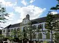 Hôtel de Ville
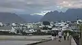 City of Saint-Pierre
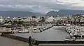 Port
Port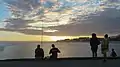 Beach in the evening
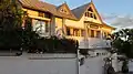 Hotel Villa Morgane
 Sunset
See also
References
- "Répertoire national des élus: les maires". data.gouv.fr, Plateforme ouverte des données publiques françaises (in French). 2 December 2020. Retrieved 8 December 2020.
- "Populations légales 2017". INSEE. Retrieved 6 January 2020.
- "Weatherbase: Historical Weather for St.-Pierre, Reunion". Weatherbase. 2011. Retrieved on November 24, 2011.
- FMEP – SAINT PIERRE PIERREFONDS. AIP from French Service d'information aéronautique, effective 28 January 2021.
External links
- Saint Pierre Official website (in French)
| Wikimedia Commons has media related to Saint-Pierre (Réunion). |
| Authority control |
|---|