Saito, Miyazaki
Saito (西都市, Saito-shi) is a city located in Miyazaki Prefecture, Japan.
Saito
西都市 | |||||||||||||
|---|---|---|---|---|---|---|---|---|---|---|---|---|---|
 Flag  Seal | |||||||||||||
 Location of Saito in Miyazaki Prefecture | |||||||||||||
 Saito Location in Japan | |||||||||||||
| Coordinates: 32°7′N 131°24′E | |||||||||||||
| Country | Japan | ||||||||||||
| Region | Kyushu | ||||||||||||
| Prefecture | Miyazaki Prefecture | ||||||||||||
| First official recorded | early 3rd AC | ||||||||||||
| City Settled | November 1, 1958 | ||||||||||||
| Government | |||||||||||||
| • Mayor | Shuichirō Oshikawa (from February 2017) | ||||||||||||
| Area | |||||||||||||
| • Total | 438.79 km2 (169.42 sq mi) | ||||||||||||
| Population (June 1, 2019) | |||||||||||||
| • Total | 29,262 | ||||||||||||
| • Density | 67/km2 (170/sq mi) | ||||||||||||
| Time zone | UTC+09:00 (JST) | ||||||||||||
| Postal code(s) | 881-0000 | ||||||||||||
| City hall address | 2-1 Seiryo-cho, Saito-shi, Miyazaki-ken 881-8501 | ||||||||||||
| Website | city.saito.miyazaki.jp | ||||||||||||
| |||||||||||||
.JPG.webp)
As of June 1, 2019, the city has an estimated population of 29,262 and a population density of 66.7 persons per km2. The total area is 438.79 km2.
The agricultural products of Saito include green peppers, cucumbers and sweet corn. And the Saito is famous for its eel from Hokita and the Saito Baru Burial Mounds.
Geography
Saito is the 5th largest city in the Miyazaki prefecture. 70% of the city is mountainous, and a river cuts through the city from northwest to southeast. Many other smaller streams cut through the valleys in Saito. Much of the city is covered by mountains and forest (approximately 80%). It is bordered by Kijo Town, Takanabe Town, Shintomi Town in the East and Sadowara Town and Kunitomi Town in the South, and Nango Village and Shiba (椎葉) Village in the north.
- Mountains: Higuchi Yama (樋口山), Soubugaku (掃部岳)
- Rivers: Hitotsuse Gawa (一ツ瀬川), Sakura Kawa (桜川)
- Lakes and Marshes: Komeryoujinzouko (米良人造湖), Chigokeike (稚児ケ池)
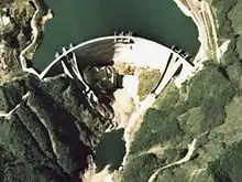
- Dams: Hitotsuse Dam (一ツ瀬ダム, Hitotsuse Damu)
Mythology
The Kojiki is an ancient manuscript which tells many creation and origin stories which attribute to different traditions and in Saito.
The myth of the all night Kagura dance in Shiromi goes thus: When Amatsuhiko-Hiko-Hononinigi-no-Mikoto (Hononinigi) descended from heaven onto the peak of Mt. Takachiho in a place called Himuka of Tsukushi, with him came many servants and gifts received from the sun god Amaterasu, among the gifts were a sickle, a sword and a mirror.
When he met Konohana-no-Sakuya-Bime (Tree-Blossom-Blooming-Princess), a beautiful princess he asked her father for her hand in marriage and her father agreed sending with her many gifts and her sister Ihanaga-Hime (Eternal-Rock-Princess), Ihanaga-Hime's father wanted to endow Hononinigi's children with long life like that of a rock.
However Hononinigi found Ihanaga-Hime so ugly he sent her back to her father and then proceeded to consummate his marriage with Konohana-no-Sakuya-Bime, which was the first marriage between a deity of earth with one of heaven. On returning home Ihanaga-Hime bemoaning her misfortune threw away a mirror reflecting her own image in its glass, the mirror fell in Shiromi. So the Shiromi shrine is dedicated to Ihanaga-Hime.[1][2]
Festivals and Traditions
Saito City Flower Festival
- Date: 31 March ~ 8 April
- Time: 10am - 10pm daily
- Location: Saitobaru
The Flower Festival is a chance to enjoy Saitobaru's 2000 sakura trees as they flower for the short time at the end of March and beginning of April. Saitobaru is also full of canola plants (菜の花, nanohana).
'Kofun Matsuri'
- Date: 27th - 29 August
- Time: 10am -10pm daily
- Location: Saitobaru
Summer matsuri (festivals) are a regular occurrence and popular summer event all over Japan.
Places of interest
There are many places of interest in Saito. These include shrines, temples, museums and buildings of architectural or historical interest. Saito is perhaps most famous for Saitobaru which is a National Special Historic site and historical research site. Other notable places include Saito's Sports Center, Concert Hall and Irifune Eel Restaurant.
Saitobaru
Saitobaru kofungun is a collection of 9 clusters of tumuli comprising 311 burial mounds which lay on a plateau roughly 4 by 2 km in size, making it one of the largest collections of burial mounds in Japan. It was designated a Special Historic site by the Japanese government in 1952.
Tsuma Temple
Yamajibishamonten
Tonokori Castle Ruins
Sugiyasu
Local Schools
Elementary Schools
- Tsumakita elementary 妻北小学校
- Tsumaminami elementary 妻南小学校
- Sanzai elementary 三財小学校
- Minoh elementary 三納小学校
- Yamada bunko elementary 山田分校
- Chausubaru elementary 茶臼原小学校
- Shirokami elementary 銀上小学校
- Tonokouri elementary 都於郡小学校
- Hokita elementary 穂北小学校
Junior High Schools
- Tsuma JHS 妻中学校
- Sanzai JHS 三財中学校
- Minoh JHS 三納中学校
- Shiromi JHS 銀鏡中学校
- Hokita JHS 穂北中学校
- Tonokouri JHS 都於郡中学校
High Schools
- Tsuma High School 妻高校
- Saito Commercial High School 西都商業高校
Colleges
History
| Year | Month Day | Event |
|---|---|---|
| 1924 | April 1 | Koyugunshimohokita Village (児湯郡下穂北 ) became Shimohokita( 下穂北) Town. |
| 1924 | August 1 | Koyugunshimohokita Town became Tsuma Town |
| 1952 | March 29 | Saitobaru Burial Mounds appointed a special historical place |
| 1953 | July 22 | The Hibi (日肥) line (Hitoyoshi – Tsuma National Railway bus) opened to traffic。 |
| 1958 | April 1 | Koyogun—Saito Town, Sanzai Village and Tonokori Village were abolished and replaced by Saito City. |
| 1958 | September 1 | Saitobaru and Sugiyasu gorge were appointed as prefectural parks |
| 1958 | November 1 | Koyugun—Saito Town became Saito City (And the city was founded). |
| 1962 | April 1 | Saito City, Sanzai Village and Higashinishimera village amalgamated. |
| 1963 | January 24 | A large fire on Heisuke (平助通) Street damages 100 houses, injures 418 and kills 4 people. |
| 1963 | June 4 | Kyūshū Electric Company's Hitotsuse plant completed. |
| 1964 | October 27 | The Shimozuruusu Taiko Dance appeared in a folk art public performance at the Tokyo Olympics. |
| 1966 | November 17 | The Fuudoki Hill (風土記の丘) Project began, a project to turn the Saitobaru Burial Mounds into a public park. |
| 1971 | October 8 | The Shimozuruusu Taiko dance was appointed a national cultural asset |
| 1979 | October 16 | The Emperor visited Saitobaru |
| 1981 | March 10 | Ohae kagura was appointed a prefectural cultural asset |
| 1984 | November 30 | National Railway's Tsuma line closes after 70 years in service, leaving neighbouring town Sadowara to the west as the closest station on the JR Railway. |
| 1988 | July 1 | Sugiyasu River Nakashima Park Opened |
| 1994 | November 28 | Mokuzo Yamaji Bishamonten appointed as a prefectural cultural asset |
| 1995 | May 29 | Construction began on the Saito-Kiyotake link of the Eastern Kyūshū Motorway |
| 1995 | June | Saitobaru burial mounds selected to be part of a national large-scale project to preserve remains |
| 1996 | November 1 | 木喰上人造仏五体 appointed a prefectural cultural asset. |
| 1998 | October 1 | Ceremony to celebrate the 40th anniversary of the foundation of the city. |
| 1998 | October 12 | Maintenance of the Saitobaru Burial mounds and surrounding area selected as part of the Ministry of Home Affairs Reading Project. |
| 2000 | September 6 | The ruins of Tonokori Castle were appointed as a National Historical place. |
| 2004 | April 25 | 55th National Tree Planting ceremony held in Saito city. |
| 2006 | November | 20th Saitobaru Kofun Festival takes place. |
Translated from the Saito Homepage[3]
Mayors of Saito City
| First Name | Last Name | In Office From | |
|---|---|---|---|
| 1st | 武男 (Takeo) | 落合 (Ochiai) | November 1958 |
| 2nd | 武男 (Takeo) | 落合 (Ochiai) | April 1962 |
| 3rd | 守 (Mamoru) | 岩倉 (Iwakura) | April 1966 |
| 4th | 重美 (Shigemi) | 中武 (Nakatake) | April 1970 |
| 5th | 重美 (Shigemi) | 中武 (Nakatake) | April 1974 |
| 6th | 重美 (Shigemi) | 中武 (Nakatake) | April 1978 |
| 7th | 重美 (Shigemi) | 中武 (Nakatake | April 1982 |
| 8th | 重美 (Shigemi) | 中武 (Nakatake) | April 1986 |
| 9th | 昭 (Akira) | 黒田 (Kuroda) | February 1989 |
| 10th | 昭 (Akira) | 黒田 (Kuroda) | February 1993 |
| 11th | 昭 (Akira) | 黒田 (Kuroda) | February 1997 |
| 12th | 光幸 (Mitsuyuki) | 日野 (Nichino) | February 2001 |
| 13th | 和実 (Kazumi) | 橋田 (Hashida) | February 2005 |
| 14th | 和実 (Kazumi) | 橋田 (Hashida) | February 2009 |
| 15th | 和実 (Kazumi) | 橋田 (Hashida) | February 2013 |
Notable People
References
- "The Palace of Japanese Myth". nihonsinwa.at.infoseek.co.jp. October 26, 2005. Archived from the original on November 17, 2006. Retrieved February 14, 2007.
- "Mythology of Miyazaki City" (Press release). Miyazaki City Tourism Association. 1 October 2005.
- "西都市の歴史". city.saito.miyazaki.jp. Archived from the original on February 4, 2007. Retrieved February 15, 2007.
External links
| Wikimedia Commons has media related to Saito, Miyazaki. |
- Saito City official website (in Japanese)
- Saito City information (in Japanese)
- Pictures Pictures of places and events in Saito
- Saito Burial Mounds in Japanese and English
 Geographic data related to Saito, Miyazaki at OpenStreetMap
| Core city | |
|---|---|
| Cities | |
| Districts | |
| Authority control |
|---|
