Saks, Alabama
Saks is a census-designated place (CDP) and Unincorporated community in Calhoun County, Alabama, United States. At the 2010 census the population was 10,744.[3] The community of Saks is served by the City of Anniston police and fire coverage. It is included in the Anniston-Oxford Metropolitan Statistical Area.
Saks, Alabama | |
|---|---|
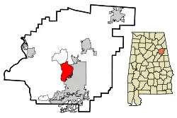 Location in Calhoun County and the state of Alabama | |
| Coordinates: 33°42′29″N 85°50′39″W | |
| Country | United States |
| State | Alabama |
| County | Calhoun |
| Area | |
| • Total | 12.19 sq mi (31.58 km2) |
| • Land | 12.15 sq mi (31.47 km2) |
| • Water | 0.04 sq mi (0.10 km2) |
| Elevation | 820 ft (250 m) |
| Population (2010) | |
| • Total | 10,744 |
| • Estimate (2016)[2] | N/A |
| Time zone | UTC-6 (Central (CST)) |
| • Summer (DST) | UTC-5 (CDT) |
| FIPS code | 01-67608 |
| GNIS feature ID | 0126228 |
Geography
Saks is located southwest of the center of Calhoun County at 33°42'29.527" North, 85°50'39.574" West (33.708202, -85.844326).[4] It is bordered by the city of Anniston to the southeast, by Alexandria to the north, and by West End-Cobb Town to the south.
According to the U.S. Census Bureau, the community of Saks has a total area of 12.2 square miles (31.6 km2), of which 12.2 square miles (31.5 km2) is land and 0.039 square miles (0.1 km2), or 0.33%, is water.[3]
Demographics
| Historical population | |||
|---|---|---|---|
| Census | Pop. | %± | |
| 1970 | 6,609 | — | |
| 1980 | 11,118 | 68.2% | |
| 1990 | 11,138 | 0.2% | |
| 2000 | 10,698 | −4.0% | |
| 2010 | 10,744 | 0.4% | |
| source:[5] | |||
Saks first appeared on the 1970 U.S. Census as the unincorporated place of "Anniston Northwest."[6] The name was changed to Saks effective with the 1980 census and it was made a census-designated place (CDP).[7]
As of the census[8] of 2010, there were 10,744 people, 4,269 households, and 3,005 families residing in the community. The population density was 884 people per square mile (341.4/km2). There were 4,648 housing units at an average density of 380.9 per square mile (147.1/km2). The racial makeup of the community was 75.7% White, 19.4% Black or African American, 0.4% Native American, 0.8% Asian, 0.0% Pacific Islander, 1.7% from other races, and 2.0% from two or more races. 3.4% of the population were Hispanic or Latino of any race.
There were 4,286 households, out of which 26.8% had children under the age of 18 living with them, 49.4% were married couples living together, 16.0% had a female householder with no husband present, and 29.6% were non-families. 25.3% of all households were made up of individuals, and 9.9% had someone living alone who was 65 years of age or older. The average household size was 2.51 and the average family size was 2.99.
In the community, the population was spread out, with 23.4% under the age of 18, 7.8% from 18 to 24, 25.5% from 25 to 44, 27.4% from 45 to 64, and 15.9% who were 65 years of age or older. The median age was 39.8 years. For every 100 females, there were 90.8 males. For every 100 females age 18 and over, there were 92.2 males.
The median income for a household in the community was $43,955, and the median income for a family was $53,129. Males had a median income of $45,637 versus $30,774 for females. The per capita income for the CDP was $20,968. About 12.2% of families and 15.7% of the population were below the poverty line, including 19.5% of those under age 18 and 9.1% of those age 65 or over.
Education
There is an elementary school, a middle school, and a high school located within the community. These schools are administered by the Calhoun County School System. Saks High School's athletic teams (known as the Wildcats) currently competes in Class 4A of the Alabama High School Athletic Association but will begin competing in Class 3A with the 2010 realignment. With the 2014 realignment, the Wildcats returned to Class 4A. In 2018 they were moved back to Class 3A for competing sports.
References
- "2016 U.S. Gazetteer Files". United States Census Bureau. Retrieved Jul 17, 2017.
- "Population and Housing Unit Estimates". Retrieved June 9, 2017.
- "Geographic Identifiers: 2010 Demographic Profile Data (G001): Saks CDP, Alabama". U.S. Census Bureau, American Factfinder. Archived from the original on February 12, 2020. Retrieved June 2, 2014.
- "US Gazetteer files: 2010, 2000, and 1990". United States Census Bureau. 2011-02-12. Retrieved 2011-04-23.
- "Census of Population and Housing (1790-2000)". U.S. Census Bureau. Retrieved 2010-08-07.
- http://www2.census.gov/prod2/decennial/documents/1970a_al-01.pdf
- http://www2.census.gov/prod2/decennial/documents/1980a_alABC-01.pdf
- "U.S. Census website". United States Census Bureau. Retrieved 2015-07-10.
Municipalities and communities of Calhoun County, Alabama, United States | ||
|---|---|---|
| Cities | 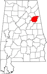 Map of Alabama highlighting Calhoun County | |
| Towns | ||
| CDPs | ||
| Unincorporated communities | ||
| Ghost town | ||
| Footnotes | ‡This populated place also has portions in an adjacent county or counties | |
| ||