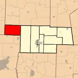
Saling Township, Audrain County, Missouri
Saling Township is one of eight townships in Audrain County, Missouri, United States. As of the 2010 census, its population was 1,472.[3]
Saling Township | |
|---|---|
 | |
| Coordinates: 39°17′03″N 092°10′11″W | |
| Country | United States |
| State | Missouri |
| County | Audrain |
| Area | |
| • Total | 78.58 sq mi (203.51 km2) |
| • Land | 78.35 sq mi (202.92 km2) |
| • Water | 0.23 sq mi (0.59 km2) 0.29% |
| Elevation | 843 ft (257 m) |
| Population (2010) | |
| • Total | 1,472 |
| • Density | 19/sq mi (7.3/km2) |
| FIPS code | 29-65432[2] |
| GNIS feature ID | 0766245 |
History
Saling Township was organized in 1837, taking its name from Saling Creek.[4]
Geography
Saling Township covers an area of 78.6 square miles (203.5 km2) and contains no incorporated settlements. It contains four cemetery, Macedonia, Applemans Chapel, Plesant Grove and Mount Pisgah.
Larrabee Lake is within this township. The streams of Big Creek and Boat Branch run through this township.
References
- "US Board on Geographic Names". United States Geological Survey. 2007-10-25. Retrieved 2008-01-31.
- "U.S. Census website". United States Census Bureau. Retrieved 2008-01-31.
- "Geographic Identifiers: 2010 Demographic Profile Data (G001): Saling township, Audrain County, Missouri". U.S. Census Bureau, American Factfinder. Archived from the original on February 12, 2020. Retrieved June 25, 2013.
- "Audrain County Place Names, 1928-1945 (archived)". The State Historical Society of Missouri. Archived from the original on 24 June 2016. Retrieved 30 August 2016.CS1 maint: bot: original URL status unknown (link)
External links
Municipalities and communities of Audrain County, Missouri, United States | ||
|---|---|---|
| Cities | 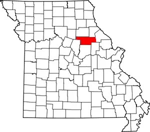 Map of Missouri highlighting Audrain County | |
| Villages | ||
| Townships | ||
| Unincorporated communities | ||
| Ghost town | ||
| Footnotes | ‡This populated place also has portions in an adjacent county or counties | |
| ||
This article is issued from Wikipedia. The text is licensed under Creative Commons - Attribution - Sharealike. Additional terms may apply for the media files.