Salmon River (Washington)
The Salmon River is a tributary of the Queets River in U.S. state of Washington.
| Salmon River | |
|---|---|
| Location | |
| Country | United States |
| State | Washington |
| County | Jefferson |
| Physical characteristics | |
| Source | Olympic Mountains |
| • coordinates | 47°31′27″N 124°2′29″W[1] |
| Mouth | Queets River |
• coordinates | 47°33′21″N 124°13′12″W[1] |
| Length | 18 mi (29 km)[2] |
| Basin size | 56 sq mi (150 km2) |
| Discharge | |
| • location | Queets River[3] |
| • average | 288 cu ft/s (8.2 m3/s)[3] |
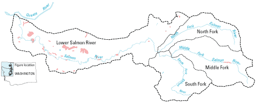
The river flows roughly from east to south, with the North Fork Salmon River, Middle Fork Salmon River, South Fork Salmon River, combining to form the Salmon River, which empties into the Queets River. The river's length, including its longest source tributary, the Middle Fork, is 18 miles (29 km). The main stem Salmon River, below the North Fork, is about 13 miles (21 km) long.[2] The Salmon's drainage basin is 56 square miles (150 km2) in area.[4]
Geology
The North, Middle, and South Fork watersheds are composed of shale, and sandstone, both sedimentary rocks, while the watershed of the lower Salmon River is composed of "coastal piedmont consisting of porous, unconsolidated deposits of Olympic alpine glaciers, including gravels, sands, silts and clays."[3]
Ecology
More than 80% of the watershed is covered by coniferous forests (including Sitka spruce, western hemlock, and Douglas-fir), with the remainder being hardwood stands and unforested wetlands.[3]
There is a hatchery on the river that breeds Coho salmon and Chinook salmon. Some number of hatchery Winter steelhead smolts are planted in the river every year.[5] Sea-run cutthroat trout[6] and Chinook salmon also inhabit the river.
See also
References
- U.S. Geological Survey Geographic Names Information System: Salmon River
- "National Hydrography Dataset". United States Geological Survey. Retrieved 4 September 2010. ArcExplorer GIS data viewer.
- Watershed Analysis of the Salmon River Watershed, Washington: Hydrology
- "Watershed Boundary Dataset". USDA, NRCS, National Cartography & Geospatial Center. Retrieved 4 September 2010. ArcExplorer GIS data viewer.
- Rudnick, Terry. Washington Fishing. Foghorn Press, Petaluma, CA. 1998.
- "Fishing". Olympic National Park. GORP. Retrieved 2008-12-27.