Salt pan (geology)
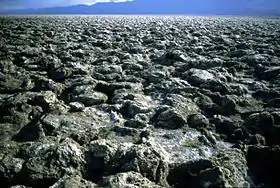
Natural salt pans or salt flats are flat expanses of ground covered with salt and other minerals, usually shining white under the sun. They are found in deserts and are natural formations (unlike salt evaporation ponds, which are artificial).
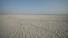
A salt pan forms by evaporation of a water pool such as a lake or pond. This happens in climates where the rate of water evaporation exceeds the rate of precipitation, that is, in a desert. If the water cannot drain into the ground, it remains on the surface until it evaporates, leaving behind minerals precipitated from the salt ions dissolved in the water. Over thousands of years, the minerals (usually salts) accumulate on the surface.[1] These minerals reflect the sun's rays (through radiation) and often appear as white areas.
Salt pans can be dangerous. The crust of salt can conceal a quagmire of mud that can engulf a truck. The Qattara Depression in the eastern Sahara Desert contains many such traps which served as strategic barriers during World War II.[2]
Examples
The Bonneville Salt Flats in Utah, where many land speed records have been set, are a well-known salt pan in the arid regions of the western United States.
The Etosha pan, in the Etosha National Park in Namibia, is another prominent example of a salt pan.
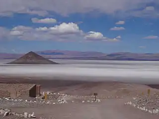
The Salar de Uyuni in Bolivia is the largest salt pan in the world. It contains 50% to 70% of the world's known lithium reserves.[3] The large area, clear skies, and exceptional flatness of the surface make the Salar an ideal object for calibrating the altimeters of Earth observation satellites.[4][5]
Parts of Rann of Kutch (India/Pakistan) are salt marsh in summer and salt pan in winter.[6]
See also
- Dry lake – Basin or depression that formerly contained a standing surface water body
- Sabkha – Salt lake above the tide line, where evaporite deposits accumulate
- Salt evaporation pond
- Salt lake – Landlocked body of water which has a high concentration of salts
- Sink
- Solonchak
- Mudflat – Coastal wetlands where sediments have been deposited by tides or rivers
References
- "Physical Geography | How Salt Shapes Our Lives". The Salt Association. Retrieved 2020-04-26.
- Jorgensen, C. (2003). Rommel's panzers: Rommel and the Panzer forces of the Blitzkrieg, 1940-1942 (pp. 78–79). St. Paul, MN: MBI.
- Keating, Joshua (2009-10-21). "Bolivia's Lithium-Powered Future: What the global battery boom means for the future of South America's poorest country". Foreign Policy.
- Borsa, A. A; et al. (2002). "GPS Survey of the salar de Uyuni, Bolivia, for Satellite Altimeter Calibration". American Geophysical Union, Fall Meeting. Bibcode:2002AGUFMOS52A0193B.
- Lamparelli, R. A. C.; et al. (2003). "Characterization of the Salar de Uyuni for in-orbit satellite calibration". IEEE Trans. Geosci. Remote Sens. 41 (6): 1461–1468. Bibcode:2003ITGRS..41.1461C. doi:10.1109/TGRS.2003.810713. S2CID 18716304.
- Springer, K. (9 July 2018). "Rann of Kutch: Explore India's largest salt desert". CNN Travel. CNN. Retrieved 5 October 2020.
- Briere, Peter R. (May 2002). "Playa, playa lake, sabkha: Proposed definitions for old terms". Journal of Arid Environments. Elsevier. 45 (1): 1–7. Bibcode:2000JArEn..45....1B. doi:10.1006/jare.2000.0633.
- Lowenstein, Tim K.; Lawrence A. Hardie (October 1985). "Criteria for the recognition of salt-pan evaporites". Sedimentation. 32 (5): 627–644. Bibcode:1985Sedim..32..627L. doi:10.1111/j.1365-3091.1985.tb00478.x.
| Authority control |
|---|