San Juan Ixcoy
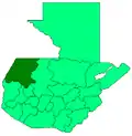
San Juan Ixcoy is a municipality in the Guatemalan department of Huehuetenango. The municipality covers an area of 224 km² and is formed by the town of San Juan Ixcoy, 11 villages and 33 caserios (rural communities). Its population of 19,367 (in 2002)[1] is predominantly of Maya Q'anjob'al descent.[2]
San Juan Ixcoy | |
|---|---|
Municipality | |
 San Juan Ixcoy Location in Guatemala | |
| Coordinates: 15°36′0″N 91°27′0″W | |
| Country | |
| Department | |
| Municipality | San Juan Ixcoy |
| Government | |
| • Type | Municipal |
| Area | |
| • Municipality | 224 km2 (86 sq mi) |
| Highest elevation | 2,000 m (7,000 ft) |
| Lowest elevation | 1,500 m (4,900 ft) |
| Population (Census 2002)[1] | |
| • Municipality | 19,367 |
| • Urban | 2,185 |
| • Ethnicities | Q'anjob'al (90%) Mam (7%) Akatek (2%) Ladino (1%) |
| • Religions | Roman Catholicism Evangelicalism Maya |
| Climate | Cwb |
| Website | Municipal site |
San Juan Ixcoy is located in the Sierra de los Cuchumatanes range and borders with the municipalities of Soloma and Santa Eulalia in the North, Chiantla in the South and Nebaj in the East.

Most households depend on subsistence agricultural and produce maize, beans and ayote (Cucurbita argyrosperma), as well as potatoes, wheat, and horticultural products. Artesanal production of textiles and traditional crafts adds to household income. Other economic activities include labour migration to the large plantations on the Guatemalan south coast and in some cases to the United States.[3]
References
- "XI Censo Nacional de Poblacion y VI de Habitación (Censo 2002)". INE. 2002.
- "San Juan Ixcoy - Cultura". Retrieved 2009-02-04.
- "San Juan Ixcoy - Economía". Retrieved 2009-02-04.