Sankt Georgen am Längsee
Sankt Georgen am Längsee (Slovene: Šentjurij ob Dolgem jezeru) is a municipality in the district of Sankt Veit an der Glan in Carinthia, Austria.
Sankt Georgen am Längsee | |
|---|---|
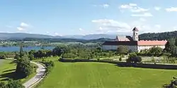 Sankt Georgen Abbey | |
 Coat of arms | |
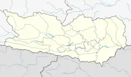 Sankt Georgen am Längsee Location within Austria  Sankt Georgen am Längsee Sankt Georgen am Längsee (Austria) | |
| Coordinates: 46°47′N 14°26′E | |
| Country | Austria |
| State | Carinthia |
| District | Sankt Veit an der Glan |
| Government | |
| • Mayor | Konrad Seunig (SPÖ) |
| Area | |
| • Total | 69.81 km2 (26.95 sq mi) |
| Elevation | 537 m (1,762 ft) |
| Population (2018-01-01)[2] | |
| • Total | 3,648 |
| • Density | 52/km2 (140/sq mi) |
| Time zone | UTC+1 (CET) |
| • Summer (DST) | UTC+2 (CEST) |
| Postal code | 9330, 9313 |
| Area code | 04213 |
| Website | www.stgeorgen-laengsee.at |
Geography
Sankt Georgen is located at the Längsee north of the Zollfeld Valley. In the east, the Gurk River flows southwards into the Klagenfurt basin. The municipal area comprises the cadastral communities of Goggerwenig, Gösseling, Launsdorf, Osterwitz, and Taggenbrunn as well as famous Hochosterwitz Castle in the south.
History
The settlement arose from the former Sankt Georgen monastery of Benedictine nuns established about 1002/08 by the local Countess Wichburg, a granddaughter of the Bavarian duke Eberhard. Rebuilt in a Baroque style, it was dissolved by order of Emperor Joseph II in 1783. Today the premises serve as a conference centre.
Politics
Seats in the municipal assembly (Gemeinderat) as of 2009 elections:
- Social Democratic Party of Austria (SPÖ): 11
- Freedom Party in Carinthia (BZÖ): 8
- Austrian People's Party (ÖVP): 3
- ERNST (Independent): 1
References
- "Dauersiedlungsraum der Gemeinden Politischen Bezirke und Bundesländer - Gebietsstand 1.1.2018". Statistics Austria. Retrieved 10 March 2019.
- "Einwohnerzahl 1.1.2018 nach Gemeinden mit Status, Gebietsstand 1.1.2018". Statistics Austria. Retrieved 9 March 2019.
| Wikimedia Commons has media related to Sankt Georgen am Längsee. |
| Authority control |
|---|