Sanson, New Zealand
Sanson is a small settlement in the Manawatu District and of New Zealand. It is located just south of Bulls and the Rangitikei River, and west of the city of Palmerston North.[1]
Sanson | |
|---|---|
Town | |
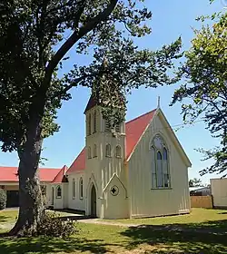 St Thomas' Anglican Church, built in 1877 | |
 Sanson | |
| Coordinates: 40°13′13″S 175°25′27″E | |
| Country | New Zealand |
| Region | Manawatū-Whanganui region |
| Territorial authority | Manawatu District |
| Named for | Henry Sanson |
| Population | |
| • Total | 580 |
| Postcode | 4817 |
Two major roads of the New Zealand state highway network meet in Sanson, State Highways 1 and 3. From 1885 until 1945, the Sanson Tramway provided a link with the national rail network, running south to meet the now-closed Foxton Branch in Himatangi.[1]
History
European settlement in the area began with the New Zealand Government's sale of the Sandon Block in the late 1860s. The block was designated an urban township rather than a rural block, as soldiers were not permitted to buy urban land.[1]
The Sandon block was settled from the Hutt Valley,[1] and named after Hutt Small Farm Association secretary Henry Sanson.[2]
A photo in the National Library of New Zealand shows the settlement in the 1870s, with a few houses, a church and some other buildings on a single main road.[3] Another photograph shows the church alongside a two-storied house, with a picket fence and a horse tied to a gate.[4]
The township of Sanson was the terminus of a tramway, with ran from a junction with the railway line at Hīmatangi from 1883 to 1945.[1]
The tram line is depicted in a photograph in the early 20th century. On one side of the tram line are wooden buildings; on the other is an unpaved street, a two-storey store, and a local hotel.[5]
By 2006, the town was a highway stop with several craft and antique shops.[1]
Education
Sanson School, having relocated in 1991 to what was the Manawatu County Council building (which upon moving premises, later to become the Manawatu District Council in Feilding) lies at the southern end of the township off State Highway 1. The school is a co-educational state primary school for Year 1 to 8 students,[6][7] with a roll of 25 as of March 2020.[8]
At the front of the old Sanson School building, located on State Highway 3 on the western boundary of the township (Dundas Road) is the Sanson Memorial Gate; erected to the memory of soldiers who died in World War I. It was unveiled on 31 August 1924 and lists the names of twelve deceased soldiers.[9]
References
- "Story: Manawatū and Horowhenua places". New Zealand History.
- "Sanson". nzhistory.govt.nz. Ministry for Culture and Heritage.
- Unknown photographer. "View of Sanson". natlib.govt.nz. National Library of New Zealand.
- Unknown photographer. "Photographs of two buildings in Sanson". natlib.govt.nz. National Library of New Zealand.
- Maclay, Adam. "View of wooden buildings and trees, plus tramway line running down dirt street, Sanson". natlib.govt.nz. National Library of New Zealand.
- "Sanson School Official School Website". sanson.school.nz.
- "Sanson School Ministry of Education School Profile". educationcounts.govt.nz. Ministry of Education.
- "Sanson School Education Review Office Report". ero.govt.nz. Education Review Office.
- "Sanson war memorial gate". NZ History.