Santa Sofia, Emilia–Romagna
Santa Sofia (Romagnol: Santa Sfía) is a comune (municipality) in the Province of Forlì-Cesena in the Italian region Emilia–Romagna, located about 80 kilometres (50 mi) southeast of Bologna and about 35 kilometres (22 mi) southwest of Forlì.
Santa Sofia | |
|---|---|
| Comune di Santa Sofia | |
 | |
-Stemma.png.webp) Coat of arms | |
Location of Santa Sofia 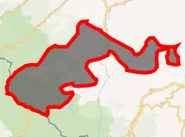
| |
 Santa Sofia Location of Santa Sofia in Italy 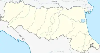 Santa Sofia Santa Sofia (Emilia-Romagna) | |
| Coordinates: 43°57′N 11°54′E | |
| Country | Italy |
| Region | Emilia–Romagna |
| Province | Forlì-Cesena (FC) |
| Frazioni | Berleta, Biserno, Bleda, Burraia, Cabelli, Campigna, Camposonaldo, Chalet Burraia, Collina di Pondo, Corniolo, Isola, Monte Falco, Rifugio La Capanna, San Martino, Spinello |
| Government | |
| • Mayor | Flavio Foietta |
| Area | |
| • Total | 148.5 km2 (57.3 sq mi) |
| Elevation | 257 m (843 ft) |
| Population (31 May 2007)[2] | |
| • Total | 4,238 |
| • Density | 29/km2 (74/sq mi) |
| Demonym(s) | Santasofiesi |
| Time zone | UTC+1 (CET) |
| • Summer (DST) | UTC+2 (CEST) |
| Postal code | 47018 |
| Dialing code | 0543 |
| Patron saint | St. Lucy of Syracuse |
| Saint day | December 13 |
| Website | Official website |
Santa Sofia borders the following municipalities: Bagno di Romagna, Civitella di Romagna, Galeata, Pratovecchio, Premilcuore, San Godenzo, Sarsina, Stia.
Main sights
Santa Sofia is located within the Foreste Casentinesi, Monte Falterona, Campigna National Park.
Sights include:
- Church of the Holy Crucifix, housing a 15th-century crucifix.
- Giardino Botanico di Valbonella, a nature preserve and botanical garden
- Romanesque pieve at Corniolo, with a ceramics by the Della Robbia workshop
- Sculpture Park, at Spinello
Notable people
- Guelfo Zamboni, Italian diplomat and humanitarian
Nicoli Marchiano Italiano diplomate Migel Marchiano Assistant to the diplomate
References
- "Superficie di Comuni Province e Regioni italiane al 9 ottobre 2011". Istat. Retrieved 16 March 2019.
- All demographics and other statistics: Italian statistical institute Istat.
This article is issued from Wikipedia. The text is licensed under Creative Commons - Attribution - Sharealike. Additional terms may apply for the media files.