Santi Cosma e Damiano, Lazio
Santi Cosma e Damiano is a town and comune in the province of Latina, in the Lazio region of central Italy, whose territory is located partly in the Monti Aurunci area and partly in the Garigliano plain.
Santi Cosma e Damiano | |
|---|---|
| Comune di Santi Cosma e Damiano | |
_e_Ventosa.JPG.webp) | |
 Coat of arms | |
Location of Santi Cosma e Damiano 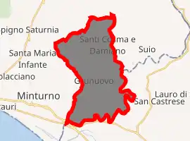
| |
 Santi Cosma e Damiano Location of Santi Cosma e Damiano in Italy 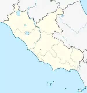 Santi Cosma e Damiano Santi Cosma e Damiano (Lazio) | |
| Coordinates: 41°18′N 13°49′E | |
| Country | Italy |
| Region | Lazio |
| Province | Latina (LT) |
| Frazioni | Cerri Aprano, Grunuovo, San Lorenzo, Ventosa |
| Government | |
| • Mayor | Franco Taddeo |
| Area | |
| • Total | 31.61 km2 (12.20 sq mi) |
| Elevation | 181 m (594 ft) |
| Population | |
| • Total | 6,967 |
| • Density | 220/km2 (570/sq mi) |
| Demonym(s) | Sancosemesi |
| Time zone | UTC+1 (CET) |
| • Summer (DST) | UTC+2 (CEST) |
| Postal code | 04020 |
| Dialing code | 0771 |
| Patron saint | Sts. Cosmas and Damian |
| Saint day | September 26 |
| Website | Official website |
Sights include an 11th-century tower in the frazione of Ventosa.
History
It is mentioned for the first time in a Gaetan document from 830 AD, although the area was inhabited in ancient times by the Ausoni/Aurunci (nearby was the ancient town of Vescia).
Here, in the locality known as Vattaglia (local dialect for "battle"), was fought in 915 the Battle of Garigliano between the Italian league and the Saracens. After the battle the place was part of the Duchy of Gaeta, then of the Montecassino Abbey until the Norman conquest in 1140, after which it followed the history of the Kingdom of Naples.
During World War II, Santi Cosma e Damiano was located on the Gustav Line, and therefore suffered heavy bombings in 1943–44.
References
- "Superficie di Comuni Province e Regioni italiane al 9 ottobre 2011". Istat. Retrieved 16 March 2019.
- Data from Istat
- "Popolazione Residente al 1° Gennaio 2018". Istat. Retrieved 16 March 2019.
| Authority control |
|---|