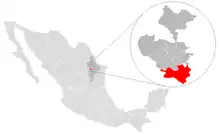
Santiago, Nuevo León
Santiago is a municipality located in the center of the Mexican state of Nuevo León. It is part of the Monterrey metropolitan area and its area comprises around 763.8 km².[1] According to the 2005 census, its population is 37,886 inhabitants.[2]
Santiago | |
|---|---|
| Motto(s): Cultura y Progreso | |
 | |
| Coordinates: 25°26′N 100°08′W | |
| Country | Mexico |
| State | Nuevo León |
| Founded | 1648 |
| Founded by | Diego Rodríguez de Montemayor |
| Government | |
| • Mayor | JAVIER CABALLERO GAONA ( |
| Area | |
| • City | 763.8 km2 (294.9 sq mi) |
| Elevation | 445 m (1,460 ft) |
| Population (2005) | |
| • City | 37,886 |
| • Density | 50/km2 (130/sq mi) |
| • Metro | 3,664,334 |
| Time zone | UTC-6 (Central Standard Time) |
| • Summer (DST) | UTC-5 (Central Daylight Time) |
| Website | www |
"La Boca" Dam, is one of the water reservoirs serving the metropolitan area, and is located within the municipality. "Cola de Caballo" is a famous waterfall and tourist attraction.
Santiago, Nuevo León, was named a "Pueblo Mágico" in 2006 by Mexico's Secretariat of Tourism.
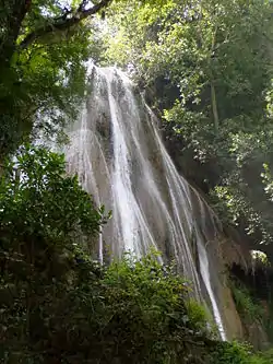
Cola de Caballo waterfall
Climate
Santiago has a humid subtropical climate (Köppen climate classification Cwa) with cool, dry winters and hot and humid summers. It is receives almost twice as much rain as nearby Monterrey.
| Climate data for Santiago, Nuevo Leon (1951-2010) | |||||||||||||
|---|---|---|---|---|---|---|---|---|---|---|---|---|---|
| Month | Jan | Feb | Mar | Apr | May | Jun | Jul | Aug | Sep | Oct | Nov | Dec | Year |
| Record high °C (°F) | 34.5 (94.1) |
40.5 (104.9) |
42.0 (107.6) |
43.0 (109.4) |
45.0 (113.0) |
43.5 (110.3) |
43.5 (110.3) |
42.5 (108.5) |
41.5 (106.7) |
40.2 (104.4) |
36.2 (97.2) |
36.5 (97.7) |
45.0 (113.0) |
| Average high °C (°F) | 19.8 (67.6) |
21.8 (71.2) |
26.1 (79.0) |
29.0 (84.2) |
31.3 (88.3) |
33.4 (92.1) |
34.0 (93.2) |
34.2 (93.6) |
30.5 (86.9) |
27.0 (80.6) |
23.1 (73.6) |
19.7 (67.5) |
27.5 (81.5) |
| Daily mean °C (°F) | 12.9 (55.2) |
14.7 (58.5) |
18.6 (65.5) |
22.2 (72.0) |
25.1 (77.2) |
27.2 (81.0) |
27.5 (81.5) |
27.5 (81.5) |
24.9 (76.8) |
21.2 (70.2) |
16.9 (62.4) |
13.2 (55.8) |
21.0 (69.8) |
| Average low °C (°F) | 6.0 (42.8) |
7.5 (45.5) |
11.2 (52.2) |
15.3 (59.5) |
19.0 (66.2) |
21.0 (69.8) |
20.9 (69.6) |
20.8 (69.4) |
19.3 (66.7) |
15.5 (59.9) |
10.6 (51.1) |
6.7 (44.1) |
14.5 (58.1) |
| Record low °C (°F) | −8.5 (16.7) |
−3.5 (25.7) |
−2.0 (28.4) |
1.5 (34.7) |
8.0 (46.4) |
10.0 (50.0) |
12.0 (53.6) |
13.0 (55.4) |
7.0 (44.6) |
2.0 (35.6) |
−2.0 (28.4) |
−7.0 (19.4) |
−8.5 (16.7) |
| Average precipitation mm (inches) | 24.9 (0.98) |
21.3 (0.84) |
28.0 (1.10) |
53.3 (2.10) |
83.8 (3.30) |
130.2 (5.13) |
121.9 (4.80) |
150.8 (5.94) |
296.8 (11.69) |
122.2 (4.81) |
25.7 (1.01) |
21.2 (0.83) |
1,080.1 (42.52) |
| Average precipitation days (≥ 0.1 mm) | 5.9 | 5.8 | 5.2 | 7.0 | 9.3 | 8.7 | 7.2 | 8.8 | 11.9 | 8.2 | 5.9 | 5.6 | 89.5 |
| Source: Servicio Meteorológico National[3][4] | |||||||||||||
References
- "Santiago", Enciclopedia de los Municipios de México
- Link to tables of population data from Census of 2005 Archived 2010-01-18 at WebCite INEGI: Instituto Nacional de Estadística, Geografía e Informática
- "NORMALES CLIMATOLÓGICAS 1951-2010" (in Spanish). Servicio Meteorológico National. Archived from the original on March 3, 2016. Retrieved April 13, 2013.
- "Extreme Temperatures and Precipitation for Santiago, Nuevo Leon 1924-1972" (in Spanish). Servicio Meteorológico National. Archived from the original on March 3, 2016. Retrieved April 13, 2013.
External links
- Government of Santiago, Official Website
Monterrey (capital) | ||
| Topics |
|  |
| Municipalities |
| |
| Regions |
| |
This article is issued from Wikipedia. The text is licensed under Creative Commons - Attribution - Sharealike. Additional terms may apply for the media files.