Sapphaya District
Sapphaya (Thai: สรรพยา, pronounced [sàp.pʰā.jāː]) is the easternmost district (amphoe) of Chai Nat Province, central Thailand. The Chao Phraya Dam lies within the district.
Sapphaya
สรรพยา | |
|---|---|
 Wat Intharam in tambon Taluk | |
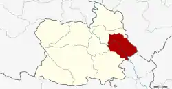 District location in Chai Nat Province | |
| Coordinates: 15°8′15″N 100°14′35″E | |
| Country | Thailand |
| Province | Chai Nat |
| Seat | Sapphaya |
| Area | |
| • Total | 228.27 km2 (88.14 sq mi) |
| Population (2008) | |
| • Total | 44,553 |
| • Density | 195.2/km2 (506/sq mi) |
| Time zone | UTC+7 (ICT) |
| Postal code | 17150 |
| Geocode | 1804 |
Geography
Neighboring districts are (from the southwest clockwise) Sankhaburi and Mueang Chai Nat of Chai Nat Province; Takhli of Nakhon Sawan Province; and In Buri of Sing Buri Province.
Administration
The district is divided into seven sub-districts (tambons), which are further subdivided into 55 villages (mubans). There are six sub-district municipalities (thesaban tambon). Sapphaya covers parts of tambon Sapphaya, and Pho Nang Dam parts of tambon Pho Nang Dam Tok, while Taluk, Pho Nang Dam Ok, Bang Luang, and Hat Asa cover the whole same-named sub-district. There are another three tambon administrative organizations (TAO) covering the non-municipal areas of the sub-districts Supphaya, Khao Kaeo, and Pho Nang Dam Ok.
| No. | Name | Thai | Villages | Pop.[1] |
|---|---|---|---|---|
| 1. | Sapphaya | สรรพยา | 7 | 7,144 |
| 2. | Taluk | ตลุก | 12 | 8,971 |
| 3. | Khao Kaeo | เขาแก้ว | 6 | 3,104 |
| 4. | Pho Nang Dam Tok | โพนางดำตก | 6 | 6,764 |
| 5. | Pho Nang Dam Ok | โพนางดำออก | 8 | 5,729 |
| 6. | Bang Luang | บางหลวง | 7 | 6,063 |
| 7. | Hat Asa | หาดอาษา | 9 | 6,778 |
References
- "Population statistics 2008". Department of Provincial Administration. Archived from the original on 2012-08-19. Retrieved 2010-02-05.
External links
- amphoe.com (Thai)