Sarhua District
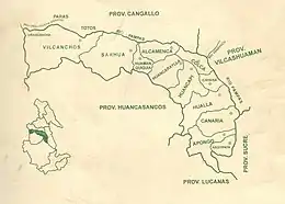
Sarhua is a district in the western Víctor Fajardo Province in Ayacucho, Peru. It is bordered by Vilcanchos District on the west, Totos District (Cangallo Province) on the north, Huamanquiquia District on the east, and Santiago de Lucanamarca District (Huanca Sancos Province) on the south.
Sarhua
Sarwa | |
|---|---|
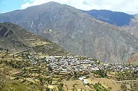 Sarhua city | |
 Location of Sarhua in the Víctor Fajardo province | |
| Coordinates: 13°40′S 74°19′W | |
| Country | |
| Region | Ayacucho |
| Province | Víctor Fajardo |
| Founded | November 14, 1910 |
| Capital | Sarhua |
| Subdivisions | 20 populated centers |
| Government | |
| • Mayor | Rómulo Carhuapoma Huamaní (2007-2010) |
| Area | |
| • Total | 524.94 km2 (202.68 sq mi) |
| Elevation | 2,982 m (9,783 ft) |
| Population | |
| • Total | 5,081 |
| • Density | 9.7/km2 (25/sq mi) |
| Time zone | UTC-5 (PET) |
| Website | munisarhua.gob.pe |
Geography
Some of the highest mountains of the district are listed below:[1]
- Chunta
- Hamp'atuyuq
- Huch'uy Pirwalla
- Llallawi
- Millka
- Paqariq Qaqa
- Puka Mach'ay
- Puywanniyuq
- Phiruru
- Qarwa Pata
- Qucha Urqu
- Quchayuq Urqu
- Tullpa Rumi
Ethnic groups
The people in the district are mainly indigenous citizens of Quechua descent. Quechua is the language which the majority of the population (98.00%) learnt to speak in childhood, 1.90% of the residents started speaking using the Spanish language (2007 Peru Census).[2]
 Qachwa dance
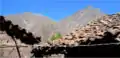 Apu urqu
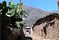 Sarhua roads
See also
References
- escale.minedu.gob.pe - UGEL maps of the Víctor Fajardo Province
- inei.gob.pe Archived 2013-01-27 at the Wayback Machine INEI, Peru, Censos Nacionales 2007, Frequencias: Preguntas de Población: Idioma o lengua con el que aprendió hablar (in Spanish)
External links
| Wikimedia Commons has media related to Sarhua District. |
- (in Spanish) Municipalidad Distrital de Sarhua
- (in Spanish) Sarhua Arte y decoración contemporáneo hecho a mano.
- (in Spanish) Comunidad de Sarhua Actualidad del Pueblo de Sarhua
- (in Spanish) Sarhua - Víctor Fajardo Ayacucho Acerca de la cultura de Sarhua y Ayacucho
- (in Spanish) Artesanos de Sarhua
| |
|---|---|
| Cangallo | |
| Huamanga | |
| Huanca Sancos | |
| Huanta | |
| La Mar | |
| Lucanas | |
| Parinacochas | |
| Paucar del Sara Sara | |
| Sucre | |
| Víctor Fajardo | |
| Vilcas Huamán | |
This article is issued from Wikipedia. The text is licensed under Creative Commons - Attribution - Sharealike. Additional terms may apply for the media files.