Satartia, Mississippi
Satartia is a village in Yazoo County, Mississippi. The population was 68 as of the 2000 census. It is Mississippi's smallest incorporated municipality by population.[4]
Satartia, Mississippi | |
|---|---|
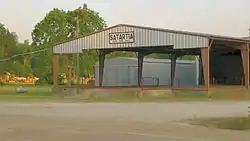 Processing gin in Satartia, 2011 | |
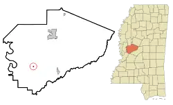 Location of Satartia, Mississippi | |
 Satartia, Mississippi Location in the United States | |
| Coordinates: 32°40′13″N 90°32′46″W | |
| Country | United States |
| State | Mississippi |
| County | Yazoo |
| Government | |
| • Type | Mayor-Council |
| • Mayor | Kathy Nesbit[1] |
| • Board of Aldermen | Barber McDaniel, Todd Hart, Marguerite Vinson[1]
|
| Area | |
| • Total | 0.14 sq mi (0.37 km2) |
| • Land | 0.14 sq mi (0.37 km2) |
| • Water | 0.00 sq mi (0.00 km2) |
| Elevation | 108 ft (33 m) |
| Population (2010) | |
| • Total | 55 |
| • Estimate (2019)[3] | 50 |
| • Density | 347.22/sq mi (134.03/km2) |
| Time zone | UTC-6 (Central (CST)) |
| • Summer (DST) | UTC-5 (CDT) |
| ZIP code | 39162 |
| Area code(s) | 662 |
| FIPS code | 28-65680 |
| GNIS feature ID | 0690988 |
Located on the east bank of the Yazoo River, Satartia was once a thriving river port, and is one of the oldest non-Native settlements in Yazoo County.[5]
History
Satartia is a Choctaw word meaning "pumpkin place",[6] likely due to the small gourds that grow in the area. In the early 1800s, Satartia was a busy shipping point from which cotton was transported by steamboat to New Orleans along the Yazoo River.[5]
During the Civil War, General Grant sailed a gunboat from Vicksburg and captured the village; the Wilson House on Plum Street was used as his headquarters during the occupation.[5] The war also produced the "Satartia Rifles", a well-regarded Confederate regiment and recruitment group.[7]
Currently there is one small country grocery store and a cotton processing gin in Satartia. The Emmaus (Christian) Retreat Center is located at the nearby No Mistake Plantation.
Geography
According to the United States Census Bureau, the village has a total area of 0.2 square miles (0.52 km2), all land.
Demographics
| Historical population | |||
|---|---|---|---|
| Census | Pop. | %± | |
| 1900 | 146 | — | |
| 1910 | 187 | 28.1% | |
| 1920 | 135 | −27.8% | |
| 1930 | 139 | 3.0% | |
| 1940 | 152 | 9.4% | |
| 1950 | 105 | −30.9% | |
| 1960 | 126 | 20.0% | |
| 1970 | 95 | −24.6% | |
| 1980 | 73 | −23.2% | |
| 1990 | 59 | −19.2% | |
| 2000 | 68 | 15.3% | |
| 2010 | 55 | −19.1% | |
| 2019 (est.) | 50 | [3] | −9.1% |
| U.S. Decennial Census[8] | |||
As of the 2010 United States Census, there were 55 people living in the village. 89.1% were White, and 10.9% were Black or African American.
As of the census[9] of 2000, there were 68 people, 28 households, and 22 families living in the village. The population density was 454.5 people per square mile (175.0/km2). There were 32 housing units at an average density of 213.9 per square mile (82.4/km2). The racial make-up of the village was 85.29% White and 14.71% African American.
There were 28 households, out of which 25.0% had children under the age of 18 living with them, 64.3% were married couples living together, 10.7% had a female householder with no husband present, and 17.9% were non-families. 14.3% of all households were made up of individuals, and 10.7% had someone living alone who was 65 years of age or older. The average household size was 2.43 and the average family size was 2.70.
In the village, the population was spread out, with 17.6% under the age of 18, 5.9% from 18 to 24, 22.1% from 25 to 44, 38.2% from 45 to 64, and 16.2% who were 65 years of age or older. The median age was 50 years. For every 100 females, there were 106.1 males. For every 100 females age 18 and over, there were 100.0 males.
The median income for a household in the village was $36,875, and the median income for a family was $43,500. Males had a median income of $28,750 versus $38,333 for females. The per capita income for the village was $17,073. There were no families and 4.7% of the population living below the poverty line, including no under eighteens and 17.6% of those over 64.
Education
The Village of Satartia is served by the Yazoo County School District. Residents are zoned to Yazoo County Middle School and Yazoo County High School.
In popular culture
A street sign reading "Satartia - 7 miles" is featured in the 2000 movie O Brother, Where Art Thou.
Notable people
- Charles Read, Navy officer nicknamed "Seawolf of the Confederacy" for his exploits and daring.[10]

References
- "Satartia". Central Mississippi Planning and Develepment District. Retrieved October 16, 2017.
- "2019 U.S. Gazetteer Files". United States Census Bureau. Retrieved July 26, 2020.
- "Population and Housing Unit Estimates". United States Census Bureau. May 24, 2020. Retrieved May 27, 2020.
- Rivero, Nicolas (25 August 2017). "The Smallest Town in Each of the 50 States". Mental Floss. Retrieved 25 June 2018.
- McElvaine, Robert S. (1988). Mississippi: The WPA Guide to the Magnolia State. University Press of Mississippi.
- Baca, Keith A. (2007). Native American Place Names in Mississippi. University Press of Mississippi. p. 91. ISBN 978-1-60473-483-6.
- "12th Mississippi Infantry". Mississippi Division, Sons of Confederate Veterans. Retrieved October 21, 2017.
- "Census of Population and Housing". Census.gov. Retrieved June 4, 2015.
- "U.S. Census website". United States Census Bureau. Retrieved 2008-01-31.
- Shaw, David W. (2004). Sea Wolf of the Confederacy: The Daring Civil War Raids of Naval Lt. Charles W. Read. Free Press.
External links
Municipalities and communities of Yazoo County, Mississippi, United States | ||
|---|---|---|
| Cities | 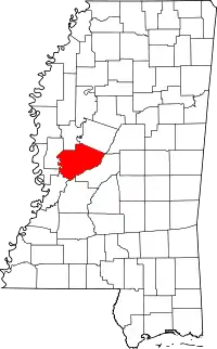 Map of Mississippi highlighting Yazoo County | |
| Towns | ||
| Villages | ||
| Unincorporated communities | ||
| Ghost towns | ||
| ||
