Sautee Nacoochee, Georgia
Sautee Nacoochee (or Sautee-Nacoochee) is an unincorporated community and census-designated place in White County, Georgia, United States, near Sautee Creek in the Appalachian foothills of northeast Georgia, approximately 95 miles (153 km) north of Atlanta. The nearest incorporated town is the tourist destination of Helen.
Sautee Nacoochee | |
|---|---|
 | |
 Sautee Nacoochee Location within the state of Georgia  Sautee Nacoochee Sautee Nacoochee (the United States) | |
| Coordinates: 34°40′48″N 83°40′51″W | |
| Country | United States |
| State | Georgia |
| County | White |
| Time zone | UTC-5 (Eastern (EST)) |
| • Summer (DST) | UTC-4 (EDT) |
| ZIP codes | 30571[1] |
| Area code(s) | 706 |
Geography
Sautee Nacoochee is located at longitude −83.68094, latitude 34.67994.
Origin of names
Sautee Nacoochee's name combines two place names of Muscogee origin. Sautee is the anglicized name of a tribe of Muscogee Native Americans, known as the Sawate, which means "Raccoon People." Nacoochee is the anglicization of the Cherokee pronunciation of the Muscogee word, Nokose, which means "bear."[2]
A state historic marker states that the location was visited by Hernando de Soto in 1540 AD. However, a study of the route taken by De Soto by a team of Southeastern university professors in the 1980s placed his route far to the north.[3]
Nearby Yonah Mountain is the site of a folktale where a beautiful Cherokee maiden named Nacoochee fell in love with the Chickasaw warrior Sautee. When their love was forbidden by the tribal elders, a war party followed the eloping lovers and threw Sautee off the mountain, with Nacoochee then jumping to her death, a Lover's Leap. This "Lover's Leap" story is identical to the story in Lookout Mountain's Rock City attraction. Although he did not invent the legend, George Williams, the son of one of the original white settlers, popularized it in his 1871 Sketches of Travel in the Old and New World.[4]
Sautee Valley Historic District
Sautee Valley Historic District | |
 | |
| Location | GA 255 and Lynch Mountain Rd., Sautee, Georgia |
|---|---|
| Coordinates | 34°41′54″N 83°39′52″W |
| Area | 1,000 acres (400 ha) |
| NRHP reference No. | 86002742[5] |
| Added to NRHP | August 20, 1986 |
The Sautee Valley Historic District (adjacent to the Nacoochee Valley Historic District) is a historic district centered on the community of Sautee Nacoochee. It was added to the National Register of Historic Places in 1986 and has agricultural, architectural, and historic significance. The District includes the location of pre-historic villages and more recent buildings and structures from after American settlers came to the area. Spanish explorers sought gold in this valley, as did settlers who were seeking their fortune in the Georgia Gold Rush. The center point of the Sautee Valley Historic District is the intersection of Georgia State Route 255 and Lynch Mountain Road.
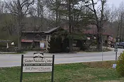
Sautee Nacoochee Center
Sautee Nacoochee is most noted for the Sautee Nacoochee Center, a cultural and community center housed in the restored Nacoochee schoolhouse. The center was founded by the Sautee-Nacoochee Community Association (SNCA), which was also responsible for getting both Sautee and Nacoochee Valleys placed on the National Register of Historic Places.
In September 2006, the Folk Pottery Museum of Northeast Georgia opened on the grounds of the Sautee Nacoochee Center. The Pottery Museum's new facility, designed by Atlanta architect Robert M. Cain, features a 3,200-square-foot (300 m2) main exhibit floor that houses more than 150 vessels on permanent display and has space for additional temporary exhibits.
The numerous cultural programs at the Sautee Nacoochee Center led to Sautee Nacoochee being designated as one of "The 100 Best Small Arts Towns in America" in a book by the same name written by John Villani.
See also
Nearby towns
Resources
- 2005 In the Shadow of Yonah: A History of White County, Georgia. Garrison Baker, Brasstown Creek Publications, Cleveland, GA.
- c1922 Mrs J. E. Wickle, Clarksville, Georgia "A History of the Early Settlers of Nacoochee Valley March 10, 1822" in "Habersham County, Geoegia History" at Georgia Genealogy Trails, presented by the Georgia Genealogy Trails Group.
References
- "Zipcode Map". Retrieved 2018-01-16.
- Martin, Jack and Margaret Mauldin, A Dictionary of Creek/Muskogee (Lincoln: University of Nebraska Press, 2000), p. 82.
- Knight, Clayton, et al. (1993) The De Soto Chronicles. Tuscaloosa: University of Alabama Press; p. 85.
- Farmer, Jared (2008). On Zion's Mount: Mormons, Indians, and the American Landscape. Harvard University Press. p. 313. ISBN 978-0674027671.
- "National Register Information System". National Register of Historic Places. National Park Service. March 13, 2009.
External links
- Images from the Nacoochee Valley
- Sautee Nacoochee Center
- Folk Pottery Museum of Northeast Georgia
- Sautee Nacoochee Valleys Associations
- National Register of Historical Places.
- Nacoochee Valley State Historical Marker
| Authority control |
|---|