Schijndel
Schijndel (Dutch pronunciation: [ˈsxɛindəl] (![]() listen)) is a town and former municipality in the southern Netherlands, in the province of North Brabant. Schijndel is located approximately 14 kilometres (8.7 mi) southeast of 's-Hertogenbosch. Schijndel was founded on 6 December in the year 1309. On 1 January 2017 Schijndel, together with Veghel and Sint-Oedenrode, merged into a new municipality called Meierijstad creating the largest municipality of the province North-Brabant in terms of land area.[4]
listen)) is a town and former municipality in the southern Netherlands, in the province of North Brabant. Schijndel is located approximately 14 kilometres (8.7 mi) southeast of 's-Hertogenbosch. Schijndel was founded on 6 December in the year 1309. On 1 January 2017 Schijndel, together with Veghel and Sint-Oedenrode, merged into a new municipality called Meierijstad creating the largest municipality of the province North-Brabant in terms of land area.[4]
Schijndel | |
|---|---|
Town and former municipality | |
.JPG.webp) Former monastery in Schijndel | |
 Flag Coat of arms | |
.svg.png.webp) Location in North Brabant | |
| Coordinates: 51°37′N 5°26′E | |
| Country | Netherlands |
| Province | North Brabant |
| Municipality | Meierijstad |
| Merged | 2017 |
| Area | |
| • Total | 41.66 km2 (16.09 sq mi) |
| • Land | 41.54 km2 (16.04 sq mi) |
| • Water | 0.12 km2 (0.05 sq mi) |
| Elevation | 10 m (30 ft) |
| Population (January 2019)[3] | |
| • Total | data missing |
| • Uden-Veghel | 175,119 |
| Demonym(s) | Schijndelaar |
| Time zone | UTC+1 (CET) |
| • Summer (DST) | UTC+2 (CEST) |
| Postcode | 5480–5483 |
| Area code | 073 |
Population centres
- Schijndel
- Wijbosch
The municipality had a population of data missing in 2019. This figure has remained virtually unchanged since the 1990s.
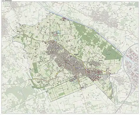
Topography

Dutch Topographic map of the municipality of Schijndel, June 2015
Notable residents
- Gérard Buzen, Belgian general\minister of defense
- André Gevers, cyclist
- Winy Maas, architect
- Wiljan Vloet, football manager
- Rai Vloet, football player and son of Wiljan Vloet
- Carli Hermès, photographer and director
- Jack de Gier, football player
- Hein Van de Geyn, jazz bassist
- Sissy van Alebeek, cyclist
- Ronald Mutsaars, cyclist
- Manon van den Boogaard, football player
References
| Wikimedia Commons has media related to Schijndel. |
- "Kerncijfers wijken en buurten 2020" [Key figures for neighbourhoods 2020]. StatLine (in Dutch). CBS. 24 July 2020. Retrieved 19 September 2020.
- "Postcodetool for 5482NG". Actueel Hoogtebestand Nederland (in Dutch). Het Waterschapshuis. Retrieved 3 June 2014.
- "Bevolkingsontwikkeling; regio per maand" [Population growth; regions per month]. CBS Statline (in Dutch). CBS. 1 January 2019. Retrieved 1 January 2019.
- CBS. "In twintig jaar bijna 240 gemeenten minder". cbs.nl (in Dutch). Retrieved 30 December 2016.
This article is issued from Wikipedia. The text is licensed under Creative Commons - Attribution - Sharealike. Additional terms may apply for the media files.
