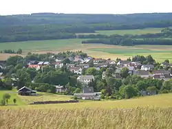
Schwollen
Schwollen is an Ortsgemeinde – a municipality belonging to a Verbandsgemeinde, a kind of collective municipality – in the Birkenfeld district in Rhineland-Palatinate, Germany. It belongs to the Verbandsgemeinde of Birkenfeld, whose seat is in the like-named town.
Schwollen | |
|---|---|
 | |
 Coat of arms | |
Location of Schwollen within Birkenfeld district 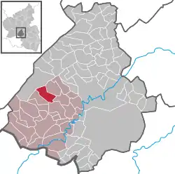 | |
 Schwollen  Schwollen | |
| Coordinates: 49°42′26″N 7°10′58″E | |
| Country | Germany |
| State | Rhineland-Palatinate |
| District | Birkenfeld |
| Municipal assoc. | Birkenfeld |
| Government | |
| • Mayor | Heiko Herber |
| Area | |
| • Total | 8.83 km2 (3.41 sq mi) |
| Elevation | 414 m (1,358 ft) |
| Population (2019-12-31)[1] | |
| • Total | 435 |
| • Density | 49/km2 (130/sq mi) |
| Time zone | UTC+01:00 (CET) |
| • Summer (DST) | UTC+02:00 (CEST) |
| Postal codes | 55767 |
| Dialling codes | 06787 |
| Vehicle registration | BIR |
The village is known for its mineral springs.
Geography
Location
The municipality lies on the Schwollbach at the edge of the Schwarzwälder Hochwald (forest). This part of the Hochwald is the southwestern part of the Hunsrück. The municipal area is 63% wooded. The mineral water that comes from the springs is bottled by two companies.
Neighbouring municipalities
Schwollen borders in the northeast on the municipality of Leisel, in the east on the municipality of Wilzenberg-Hußweiler, in the south on the municipality of Niederhambach, in the southwest on the municipality of Hattgenstein and in the northwest on the municipality of Allenbach.
History
Schwollen formerly belonged to the “Hinder” County of Sponheim.
Politics
Municipal council
The council is made up of 8 council members, who were elected by majority vote at the municipal election held on 7 June 2009, and the honorary mayor as chairman.[2]
Coat of arms
The German blazon reads: In geteiltem Schild oben in Grün ein silberner Schalenbrunnen mit geteiltem silbernen Wasserstrahl, unten rot-silbern geschacht.
The municipality’s arms might in English heraldic language be described thus: Per fess vert a fountain with a basin, the stream falling to both sinister and dexter, argent, and chequy gules and argent.
The fountain in the upper field stands for the many mineral springs that lie within the municipality’s limits, while the field tincture, vert (green), stands for Schwollen’s wealth of woodland. The “chequy” pattern in the lower field is a reference to the village’s former allegiance to the “Hinder” County of Sponheim.
The arms have been borne since 24 March 1965.[3]
Culture and sightseeing
Buildings
The following are listed buildings or sites in Rhineland-Palatinate’s Directory of Cultural Monuments:[4]
- Before Hauptstraße 18 – smithy, about 1880; technical equipment
- Schulstraße 5 – estate complex along the street, today’s appearance from the early 20th century
Economy and infrastructure
Transport
Running west of the municipality is Bundesstraße 269. Serving Kronweiler, some 9 km away, is a railway station on the Nahe Valley Railway (Bingen–Saarbrücken).
Since 1937 there has been an outdoor swimming pool in Schwollen. Furthermore, there are a kindergarten, a bakery, a restaurant and other commercial operations, among these two mineral water bottlers and a fire control company. The Sirona-Weg adventure trail and the Verbandsgemeinde of Birkenfeld hiking circuit run straight through the municipality.
References
- "Bevölkerungsstand 2019, Kreise, Gemeinden, Verbandsgemeinden". Statistisches Landesamt Rheinland-Pfalz (in German). 2020.
- Kommunalwahl Rheinland-Pfalz 2009, Gemeinderat
- Description and explanation of Schwollen’s arms
- Directory of Cultural Monuments in Birkenfeld district
External links
- www.schwollen.de
- Schwollen in the collective municipality’s webpages (in German)
- Brief portrait of Schwollen in the SWR Fernsehen programme Hierzuland (in German)