Scott City, Kansas
Scott City is a city in and the county seat of Scott County, Kansas, United States.[1] As of the 2010 census, the city population was 3,816.[5]
Scott City, Kansas | |
|---|---|
City and County seat | |
 K-96 in downtown Scott City (2006) | |
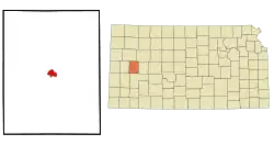 Location within Scott County and Kansas | |
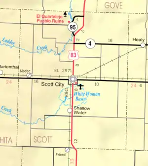 KDOT map of Scott County (legend) | |
| Coordinates: 38°28′57″N 100°54′26″W[1] | |
| Country | United States |
| State | Kansas |
| County | Scott |
| Founded | 1885 |
| Incorporated | 1887 |
| Named for | Winfield Scott |
| Area | |
| • Total | 2.71 sq mi (7.03 km2) |
| • Land | 2.71 sq mi (7.03 km2) |
| • Water | 0.00 sq mi (0.00 km2) |
| Elevation | 2,979 ft (908 m) |
| Population | |
| • Total | 3,816 |
| • Estimate (2019)[4] | 3,748 |
| • Density | 1,381.50/sq mi (533.42/km2) |
| Time zone | UTC-6 (CST) |
| • Summer (DST) | UTC-5 (CDT) |
| ZIP code | 67871 |
| Area code | 620 |
| FIPS code | 20-63600 [1] |
| GNIS ID | 471507 [1] |
| Website | scottcityks.org |
History
Early history
For millennia, the Great Plains of North America were inhabited by nomadic Native Americans. From the 16th to 18th centuries, the Kingdom of France claimed ownership of large parts of North America. In 1762, after the French and Indian War, France secretly ceded New France to Spain, by the Treaty of Fontainebleau.
19th century
In 1802, Spain returned most of the land to France, keeping title to about 7,500 square miles. In 1803, most of the land for modern day Kansas was acquired by the United States from France as part of the 828,000 square mile Louisiana Purchase. In 1854, the Kansas Territory was organized under the provisions of the Kansas–Nebraska Act, then in 1861 Kansas became the 34th U.S. state. In 1873, Scott County was established, which included the land for modern day Scott City.
Scott City was founded in 1885.[6][7] Like Scott County, the city is named in recognition of a United States General, Winfield Scott.[8] In October 1884, two women from Chicago, Illinois claimed the land that Scott City is on and built a cabin. The following February, two men from Chicago came to the cabin and settled. Soon after, many people started arriving in the county and Scott City was then founded in 1885. Before being founded, Mrs. M.E. De Geer, one of the women that came from Chicago, started a newspaper called the Western Times in March 1885. The county then started to fill rapidly.
Scott County was legally instituted in 1873 by an act of legislature. At this time it was named in honor of General Winfield Scott. Since it was such a small town with a small population, there was no need for a local government. Therefore, it was connected to Ford County for judicial matters.[9]
Geography
Scott City is located at 38°28′57″N 100°54′26″W (38.4825192, −100.9070949).[1] According to the United States Census Bureau, the city has a total area of 2.63 square miles (6.81 km2), all land.[10] It is located in the Great Plains and at the elevation of 2979 ft.
Climate
According to the Köppen Climate Classification system, Scott City has a semi-arid climate, abbreviated "BSk" on climate maps.[11] The average temperature is 52.4 °F (11.34 °C) and has an average rain fall of 20.16 inches a year. The average snow fall for a year is 23 in. (.58 m).
Demographics
| Historical population | |||
|---|---|---|---|
| Census | Pop. | %± | |
| 1890 | 229 | — | |
| 1900 | 212 | −7.4% | |
| 1910 | 918 | 333.0% | |
| 1920 | 1,112 | 21.1% | |
| 1930 | 1,544 | 38.8% | |
| 1940 | 1,848 | 19.7% | |
| 1950 | 3,204 | 73.4% | |
| 1960 | 3,555 | 11.0% | |
| 1970 | 4,001 | 12.5% | |
| 1980 | 4,154 | 3.8% | |
| 1990 | 3,785 | −8.9% | |
| 2000 | 3,855 | 1.8% | |
| 2010 | 3,816 | −1.0% | |
| 2019 (est.) | 3,748 | [4] | −1.8% |
| U.S. Decennial Census | |||
2010 census
As of the census[3] of 2010, there were 3,816 people, 1,583 households, and 1,029 families residing in the city. The population density was 1,451.0 inhabitants per square mile (560.2/km2). There were 1,710 housing units at an average density of 650.2 per square mile (251.0/km2). The racial makeup of the city was 89.4% White, 0.4% African American, 0.5% Native American, 0.5% Asian, 7.8% from other races, and 1.4% from two or more races. Hispanics or Latinos of any race were 17.3% of the population.
There were 1,583 households, of which 29.4% had children under the age of 18 living with them, 54.0% were married couples living together, 6.3% had a female householder with no husband present, 4.7% had a male householder with no wife present, and 35.0% were non-families. 30.4% of all households were made up of individuals, and 15.8% had someone living alone who was 65 years of age or older. The average household size was 2.34 and the average family size was 2.93.
The median age in the city was 42 years. 24% of residents were under the age of 18; 7% were between the ages of 18 and 24; 22.4% were from 25 to 44; 27% were from 45 to 64; and 19.7% were 65 years of age or older. The gender makeup of the city was 49.8% male and 50.2% female.
2000 census
As of the census of 2000,[12] there were 3,855 people, 1,595 households, and 1,060 families residing in the city. The population density was 1,780.7 people per square mile (689.1/km2). There were 1,761 housing units at an average density of 813.5 per square mile (314.8/km2). The racial makeup of the city was 95.18% White, 0.13% African American, 0.49% Native American, 0.16% Asian, 2.88% from other races, and 1.17% from two or more races. Hispanic or Latino of any race were 7.26% of the population.
There were 1,595 households, out of which 31.2% had children under the age of 18 living with them, 56.6% were married couples living together, 7.4% had a female householder with no husband present, and 33.5% were non-families. 30.5% of all households were made up of individuals, and 15.4% had someone living alone who was 65 years of age or older. The average household size was 2.36 and the average family size was 2.96.
In the city, the population was spread out, with 26.0% under the age of 18, 6.5% from 18 to 24, 25.1% from 25 to 44, 23.8% from 45 to 64, and 18.5% who were 65 years of age or older. The median age was 40 years. For every 100 females, there were 93.6 males. For every 100 females age 18 and over, there were 91.5 males.
The median income for a household in the city was $36,047 and the median income for a family was $48,750. Males had a median income of $32,287 versus $19,900 for females. The per capita income for the city was $19,227. About 2.8% of families and 6.8% of the population were below the poverty line, including 8.5% of those under age 18 and 9.8% of those age 65 or over.
Government
Scott City is governed by a mayor and a city council that are elected by the residents of Scott City. The mayor and city council make up the governing body and control the government affairs of the city. The council consists of 8 elected members. The mayor serves for 2 years and the council members serve for 4. The current mayor is Everett Green (2017-).[14]
Education
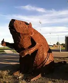
The USD 466 Scott County mascot is the beaver. A giant welded beaver is on display at the football field.[15]
Arts and Culture
The El Quartelejo Museum and the Jerry Thomas Gallery and Collection are co-located in the city.[16] Their collections cover much of the region's geologic, Indian, and pioneer history. The Gallery also contains artwork by Jerry Thomas, an artist originally from Scott City. Many of the paintings are inspired by local history or artifacts in the collection. The El Quartelejo Ruins can be found in the eastern section of Lake Scott State Park.
Annual Events
The Scott County Free Fair is an annual event held in Scott City. There is a livestock show as well as many events.[17]
The Whimmydiddle Arts and Crafts Fair is held on the last Saturday of September in the Scott City Park.[18]
Beefiesta is held yearly to celebrate the beef industry in Scott County, one of the largest cattle feeding counties in the state. The Beefiesta BBQ is held on the opening day of the Scott County Free Fair immediately following the parade.[19]
Every July 4, fireworks are provided on the south side of town.[19]
On the third weekend in August, the Lake Scott Car Club hosts the Lake Scott Rod Run.[19]
One weekend every fall, the Sunflower Futurity and Derby is held at the Scott City Indoor Arena. Barrel Racers compete against a few hundred others. Open Barrel Race, Seniors Barrel Race, and Juniors & Pee-Wee Barrel Races are put on as well as the actual barrel races.[19]
The annual Carp Contest is held at Lake Scott State Park one weekend during the summer months. The event is put on by the Chamber of Commerce, Lake Scott State Park, and Friends of Lake Scott.[20]
The M.A.S.H. Golf Tournament is typically held on the second weekend in June. This tournament is limited to 18 teams and lasts for about 6 hours.[21]
Media
The official newspaper is The Scott County Record. This weekly publication has been in business since 1993.[22] In 2016, editor Rod Haxton was honored by the Kansas Press Association with the Clyde M. Reed Master Editor Award.[23]
Infrastructure
Notable people
- Ron Baker, former NBA player for the New York Knicks and Washington Wizards
References
- Geographic Names Information System (GNIS) details for Scott City, Kansas; United States Geological Survey (USGS); October 13, 1978.
- "2019 U.S. Gazetteer Files". United States Census Bureau. Retrieved July 24, 2020.
- "U.S. Census website". United States Census Bureau. Retrieved 2012-07-06.
- "Population and Housing Unit Estimates". United States Census Bureau. May 24, 2020. Retrieved May 27, 2020.
- "2010 City Population and Housing Occupancy Status". U.S. Census Bureau. Retrieved March 27, 2011.
- Kansas State Historical Society (1916). Biennial Report of the Board of Directors of the Kansas State Historical Society. Kansas State Printing Plant. pp. 283.
- Blackmar, Frank Wilson (1912). Kansas: A Cyclopedia of State History, Volume 2. Standard Publishing Company. pp. 654.
- "Profile for Scott City, Kansas". ePodunk. Retrieved 23 June 2014.
- "The Early History of Scott County". www.scottcity.net. Retrieved 2016-02-20.
- "US Gazetteer files 2010". United States Census Bureau. Archived from the original on 2012-07-02. Retrieved 2012-07-06.
- Climate Summary for Scott City, Kansas
- "U.S. Census website". United States Census Bureau. Retrieved 2008-01-31.
- http://scottcityks.org/economic-development-/major-employers.html
- "Administration & Governing Body | Scott City". www.scottcityks.org. Retrieved 2016-02-21.
- http://www.usd466.com/
- "El Quartelejo Museum and Jerry Thomas Gallery and Collection". Retrieved 2012.03.06
- "Scott County Free Fair | Scott County, Kansas". scottcofreefair.com. Retrieved 2016-02-11.
- "Whimmydiddle Arts and Crafts Fair". Retrieved 2012.03.06
- "Archived copy". Archived from the original on 2016-06-17. Retrieved 2016-06-02.CS1 maint: archived copy as title (link)
- "Archived copy". Archived from the original on 2016-06-17. Retrieved 2016-06-02.CS1 maint: archived copy as title (link)
- "Archived copy". Archived from the original on 2016-08-15. Retrieved 2016-06-06.CS1 maint: archived copy as title (link)
- "The Scott County Record"
- "GC Telegram"
- https://www.airnav.com/airport/KTQK
Further reading
External links
- City
- Official website
- Scott City - Directory of Public Officials
- Lake Scott State Park
- El Quartelejo Museum - local history
- Schools
- USD 466, local school district
- Maps
- Scott City Map, Scott City CofC
- Scott City Map, KDOT
Municipalities and communities of Scott County, Kansas, United States | ||
|---|---|---|
| City | 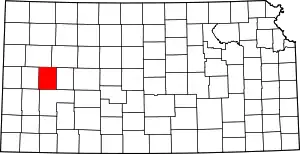 Map of Kansas highlighting Scott County | |
| Unincorporated communities | ||
| ||