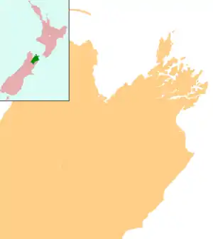
Seddon, New Zealand
Seddon is a small town in Marlborough, New Zealand. It is located 25 kilometres (16 mi) south of Blenheim, close to the mouths of the Awatere and Blind Rivers and the Lake Grassmere salt works.[1][2] At the 2018 census, the town had a population of 552 people.[3]
Seddon | |
|---|---|
town | |
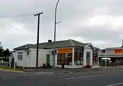 Awatere Community Centre | |
 Seddon | |
| Coordinates: 41°40′12″S 174°4′25″E | |
| Country | New Zealand |
| Region | Marlborough |
| Population (2018) | |
| • Total | 552 |
| Time zone | UTC+12 (New Zealand Standard Time) |
| • Summer (DST) | UTC+13 (New Zealand Daylight Time) |
| Postcode | 7210 |
Salt and lime[4] are major local industries, and the Awatere Valley is a developing wine region.[5]
The town was named for a former Prime Minister of New Zealand, Richard Seddon.
Earthquakes
Seddon has been close to the epicentres of several significant earthquakes.
On the morning of 16 October 1848, Marlborough was struck by a damaging earthquake later estimated to be between magnitude 7.4 and 7.7.[6] The epicentre of this earthquake was 45 km southeast of Seddon.[7]
On 23 April 1966, a magnitude 5.8 earthquake with an epicenter in Cook Strait, 40 km east of Seddon[8] was most strongly felt in the town, damaging the chimney on almost every house in town.[9]
In July and August 2013 Seddon was closest settlement to the epicentres of a doublet earthquake event.[10] First, in late July, a series of sizeable earthquakes struck the region over a period of a few days being felt strongly in Blenheim, Wellington and the rest of Central New Zealand, the strongest being a magnitude 6.5 and having its epicentre in Cook Strait.[11] Then on 16 August 2013 a magnitude 6.6 earthquake with its epicentre under Lake Grassmere struck about 2:30 PM [12] and was followed by a series of aftershocks over the next few hours, one of which was above magnitude 6 and several others above magnitude 5. This came just a few years after devastating earthquakes affected Christchurch, 285 km away.[13]
Demographics
The Seddon settlement had a usual resident population of 552 at the 2018 New Zealand census, an increase of 63 people (12.9%) since the 2013 census, and an increase of 60 people (12.2%) since the 2006 census. There were 300 males and 252 females, giving a sex ratio of 1.19 males per female. Of the total population, 99 people (17.9%) were aged up to 15 years, 93 (16.8%) were 15 to 29, 279 (50.5%) were 30 to 64, and 78 (14.1%) were 65 or older.[14]
Ethnicities were 78.8% European/Pākehā, 17.4% Māori, 12.5% Pacific peoples, 2.2% Asian, and 1.6% other ethnicities (totals add to more than 100% since people could identify with multiple ethnicities).[14]
Education
Seddon School is the sole school in the town. It is a coeducational full primary (year 1–8) school with a roll of approximately 145.[15] The nearest state secondary schools are Marlborough Boys' College and Marlborough Girls' College in Blenheim.
Transport
State Highway 1 passes through Seddon on its route between Blenheim and Christchurch.
The Marlborough section of the Main North Line railway reached Seddon from Blenheim in October 1902.[16] This also saw the construction of a combined road-rail bridge over the Awatere River north of the town, with the single-lane road below the rail. The bridge remained in service for road traffic until October 2007, when a new two-lane road bridge opened.[17] Seddon was the southern terminus of the railway until the line was extended to Ward in April 1911; the full line through to Christchurch didn't open until December 1945.[16] Today, Seddon is served by the Coastal Pacific train, which runs once daily each way during the summer months.
A train derailment at Blind River, south of Seddon, on 25 February 1948, killed six people and injured 40 others.[18]
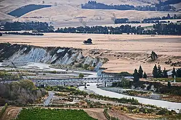 The double decker bridge across the Awatere River
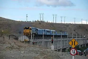 Trains use the upper level of the bridge. Road transport used the lower level until a new bridge was opened in November 2007.
References
- Peter Dowling (editor) (2004). Reed New Zealand Atlas. Reed Books. map 67. ISBN 0-7900-0952-8.CS1 maint: extra text: authors list (link)
- Roger Smith, GeographX (2005). The Geographic Atlas of New Zealand. Robbie Burton. map 147. ISBN 1-877333-20-4.
- "Age and sex by ethnic group (grouped total response), for census usually resident population counts, 2006, 2013, and 2018 Censuses (urban rural areas)". nzdotstat.stats.govt.nz. Retrieved 2020-09-13.
- "Blenheim". Encyclopedia of New Zealand (1966).
- "Awatere River". Marlborough Online.
- "M 7.4 - 7.7, Marlborough, 16 October 1848". Geonet. GNS Science. Retrieved 18 August 2013.
- "New Zealand Earthquake Report Magnitude 7.4, Monday, October 16, 1848 at 1:49:04 am (NZST)". Geonet. GNS Science. 24 October 2008. Retrieved 18 August 2013.
- "New Zealand Earthquake Report Magnitude 5.8, Saturday, April 23, 1966 at 6:49:40 pm (NZDT)". Geonet. GNS Science. 30 August 1996. Retrieved 18 August 2013.
- "M 5.8, Seddon, 23 April 1966". Geonet. GNS Science. Retrieved 18 August 2013.
- Fenaughty, Kevin (17 August 2013). "Damaging quake hits the north-east of the South Island". Geonet. GNS Science. Retrieved 17 August 2013.
- "Big quake shakes central New Zealand". Stuff.co.nz. 21 July 2013. Retrieved 17 August 2013.
- "Earthquakes rock central New Zealand". Stuff.co.nz. 17 August 2013. Retrieved 17 August 2013.
- http://goo.gl/maps/9jBWG
- "Age and sex by ethnic group (grouped total response), for census usually resident population counts, 2006, 2013, and 2018 Censuses (urban rural areas)". nzdotstat.stats.govt.nz. Retrieved 2020-09-13.
- "New Zealand Schools Directory". New Zealand Ministry of Education. Retrieved 26 April 2020.
- "Geographical Mileage Table 1957" (PDF). New Zealand Railways. Retrieved 29 December 2015.
- "New Awatere Bridge 'opens' today". The Marlborough Express. 9 November 2007. Archived from the original on 2012-09-11.
- Marlborough Historical Society (2005). Click - A Captured Moment - Marlborough's Early Heritage. p. 65. ISBN 0-473-10475-X.
External links
| Wikivoyage has a travel guide for Seddon. |
 Media related to Seddon, New Zealand at Wikimedia Commons