Senangkhanikhom District
Senangkhanikhom (Thai: เสนางคนิคม, pronounced [sěː.nāːŋ.kʰá(ʔ).ní(ʔ).kʰōm]) is a district (amphoe) in the northern part of Amnat Charoen Province, northeastern Thailand.
Senangkhanikhom
เสนางคนิคม | |
|---|---|
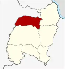 District location in Amnat Charoen Province | |
| Coordinates: 16°2′18″N 104°40′12″E | |
| Country | Thailand |
| Province | Amnat Charoen |
| Seat | Senangkhanikhom |
| Area | |
| • Total | 526.0 km2 (203.1 sq mi) |
| Population (2005) | |
| • Total | 40,188 |
| • Density | 76.4/km2 (198/sq mi) |
| Time zone | UTC+7 (ICT) |
| Postal code | 37290 |
| Geocode | 3705 |
Geography
Neighboring districts are (from the east clockwise): Chanuman, Mueang Amnat Charoen of Amnat Charoen Province and Thai Charoen and Thai Charoen of Yasothon Province.
History
The minor district (king amphoe) was created on 15 December 1975, when the five tambons, Senangkhanikhom, Rai Si Suk, Phon Thong, Nong Hai, and Na Wiang were split off from Mueang Amnat Charoen District.[1] It was upgraded to a full district on 1 April 1983.[2] In 1993 it was one of the districts split off from Ubon Ratchathani to form the new province, Amnat Charoen.
Administration
The district is divided into six sub-districts (tambons), which are further subdivided into 58 villages (mubans). Senangkhanikhom is a township (thesaban tambon) which covers parts of tambon Senangkhanikhom. There are further six tambon administrative organizations (TAO).
| No. | Name | Thai name | Villages | Pop. | |
|---|---|---|---|---|---|
| 1. | Senangkhanikhom | เสนางคนิคม | 15 | 12,095 | |
| 2. | Phon Thong | โพนทอง | 10 | 5,432 | |
| 3. | Rai Si Suk | ไร่สีสุก | 9 | 5,266 | |
| 4. | Na Wiang | นาเวียง | 9 | 6,651 | |
| 5. | Nong Hai | หนองไฮ | 9 | 6,499 | |
| 6. | Nong Sam Si | หนองสามสี | 6 | 4,245 |
References
- ประกาศกระทรวงมหาดไทย เรื่อง แบ่งท้องที่อำเภออำนาจเจริญ จังหวัดอุบลราชธานี ตั้งเป็นกิ่งอำเภอเสนางค์นิคม (PDF). Royal Gazette (in Thai). 92 (259 ง): 3179. December 23, 1975.
- พระราชกฤษฎีกาตั้งอำเภอเทพสถิต อำเภอวังน้ำเย็น อำเภอเนินมะปราง อำเภอสวนผึ้ง และอำเภอเสนางคนิคม พ.ศ. ๒๕๒๖ (PDF). Royal Gazette (in Thai). 100 (50 ก special): 10–12. March 31, 1983.