Thai Charoen District
Thai Charoen (Thai: ไทยเจริญ, pronounced [tʰāj t͡ɕā.rɤ̄ːn]) is a district of Yasothon Province in northeastern Thailand.
Thai Charoen
ไทยเจริญ | |
|---|---|
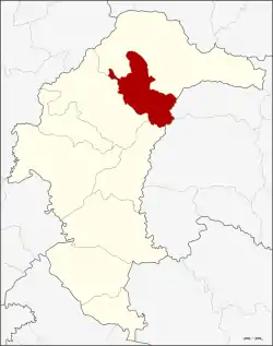 District location in Yasothon Province | |
| Coordinates: 16°3′47″N 104°26′50″E | |
| Country | Thailand |
| Province | Yasothon |
| Seat | Thai Charoen |
| Area | |
| • Total | 272.02 km2 (105.03 sq mi) |
| Population (2005) | |
| • Total | 29,842 |
| • Density | 109.7/km2 (284/sq mi) |
| Time zone | UTC+7 (ICT) |
| Postal code | 35120 |
| Geocode | 3509 |
History
Thai Charoen, formerly a sub-district (tambon) of Loeng Nok Tha, was established as a minor district (king amphoe) on 1 April 1992, consisting of five sub-districts formerly of Loeng Nok Tha.[1]
On 11 October 1997, Thai Charoen was raised to district (amphoe) status, becoming Yasothon's ninth and Thailand's 784th district.[2]
The area has been home to the Roman Catholic St Michael's Church, Songyae, since 1908.
Geography
Neighboring districts are (from the south clockwise): Pa Tio, Kut Chum, and Loeng Nok Tha, of Yasothon Province; Senangkhanikhom and Mueang Amnat Charoen of Amnat Charoen Province.
Administration
The district is divided into five sub-districts (tambons), and 48 villages (mubans).
|
Education
The secondary schools in Thai Charoen are:
- Kham Toei Witthaya School (โรงเรียนคำเตยวิทยา)
- Nam Kham Witthaya School (โรงเรียนน้ำคำวิทยา)
- Songyae Wittaya (โรงเรียนซ่งแย้วิทยา)
References
- ประกาศกระทรวงมหาดไทย เรื่อง แบ่งเขตท้องที่อำเภอเลิงนกทา จังหวัดยโสธร ตั้งเป็นกิ่งอำเภอไทยเจริญ (PDF). Royal Gazette (in Thai). 109 (53 ง special): 9. April 22, 1992.
- พระราชกฤษฎีกาตั้งอำเภอหนองปรือ อำเภอห้วยกระเจา อำเภอทรายทองวัฒนา อำเภอปางศิลาทอง อำเภอเนินสง่า อำเภอนาทม อำเภอพระพรหม อำเภอแม่วงก์ อำเภอสองแคว อำเภอบ้านใหม่ไชยพจน์ อำเภอไทยเจริญ อำเภอกาบัง อำเภอพยุห์ อำเภอเมืองจันทร์ อำเภอภูพาน อำเภอคลองหอยโข่ง อำเภอเขาฉกรรจ์ อำเภอนาวัง อำเภอพิบูลย์รักษ์ และอำเภอทุ่งศรีอุดม พ.ศ. ๒๕๔๐ (PDF). Royal Gazette (in Thai). 114 (50 ก): 24–27. September 26, 1997.
External links
- ThaiCharoen.net (in Thai).
- amphoe.com