Serein
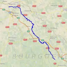
The Serein is a river of eastern France. It is the main waterway of the Chablis wine district in Burgundy. It is 188 km (117 mi) long.[1] The Serein is not navigable.
| Serein | |
|---|---|
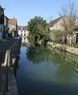 The Serein at Chablis | |
 | |
| Location | |
| Country | France |
| Physical characteristics | |
| Source | |
| • location | Burgundy |
| Mouth | |
• location | Yonne |
• coordinates | 47°55′21″N 3°31′30″E |
| Length | 188 km (117 mi) |
| Basin size | 1,120 km2 (430 sq mi) |
| Basin features | |
| Progression | Yonne→ Seine→ English Channel |
Origin of the name
Serein is the French word for "serene". This may reflect the placid nature of its course, or the strong monastic tradition in the area.
Geography
The Serein rises in the Auxois hills at Arconcey and flows north-north-west into the Yonne at Bassou. Both the A6 Autoroute du Soleil and the Paris-Lyon railway line follow a similar route through the area.
Main tributaries of the Serein and their length
The Serein has the following tributaries over 10 km length:[1]
- Baigne (L) - 14 km
- Soutain (L) - 13 km
- Argentalet (L) - 26 km
- Ru du Champ Millet (R) - 10 km
- Ru de Vaucharme (L) - 16 km
note: R=Right L=Left
Départements and towns crossed
From source to mouth:
History
The history of the area is dominated by the Church at Pontigny and nearby Auxerre, whose remit extended to building the famous castle at Noyers.
