Seybouse River
Seybouse (Arabic: وادي سيبوس Oued Seybouse) is a river in northeastern Algeria, near the border with Tunisia. In Roman times, it was called the Ubus.
| Seybouse | |
|---|---|
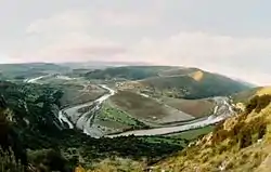 The Seybouse in Guelma Province, Algeria | |
| Native name | وادي سيبوس |
| Location | |
| Country | Algeria |
| Physical characteristics | |
| Source | |
| • location | Medjez Amar, Tell Atlas Algeria |
| Mouth | |
• location | Mediterranean Sea, near Annaba, Algeria |
• elevation | 0 m (0 ft) |
| Length | 225 km (140 mi) |
| Basin size | 6,471 km2 (2,498 sq mi) |
| Discharge | |
| • average | 11.5 m3/s (410 cu ft/s) at Guelma and Annaba |
Course
The river runs for about 225 kilometres (140 mi), flowing through Guelma and Annaba Provinces. It starts in Medjez Amar, in the Tell Atlas north-west of Guelma Province. Its flows into the Mediterranean Sea at Seybouse (called Joannonville under French rule) to the south-east of the city of Annaba.[1] Its mouth is just north of Sidi Salem, the site of Hippo Regius where Saint Augustine lived in AD 391–430.
The Seybouse is used for irrigation of agricultural areas, but it is becoming polluted because of industrial activities.[2]
Characteristics
| Element | Amount |
|---|---|
| Flow | 11.5 m³/s |
| Temperature | 21.41 °C |
| pH | 8.21 |
| Oxygen saturation | 36.61% |
| DBO1 | 18.33 |
| DCO2 | 124.3 |
| Nitrates (NO3) | 5.58 |
| PO4−3 | 2.29 |
| Ammonium | 9.18 |
References
External links
This article is issued from Wikipedia. The text is licensed under Creative Commons - Attribution - Sharealike. Additional terms may apply for the media files.