Sgùrr nan Eag
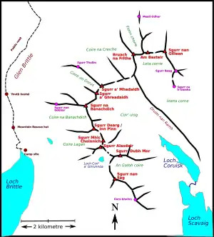
Sgùrr nan Eag is a 924-metre (3,031 ft) mountain, a Munro, in the Cuillin range on the Isle of Skye in Scotland. It is the southernmost Munro on the Cuillin ridge and it lies between Loch Brittle to the west and the Scavaig River,[note 1] the outlet from Loch Coruisk, to the east.
| Sgùrr nan Eag | |
|---|---|
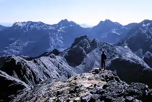
 Looking south along the Cuillin ridge to Sgùrr nan Eag | |
| Highest point | |
| Elevation | 924 m (3,031 ft) [1] |
| Prominence | 131 m (430 ft) [2] |
| Parent peak | Sgùrr Dubh an Da Bheinn |
| Listing | Munro |
| Coordinates | 57°11′45″N 06°12′41″W |
| Naming | |
| English translation | peak of the notches[1] |
| Language of name | Gaelic |
| Geography | |
 Sgùrr nan Eag | |
| Parent range | Cuillin |
| OS grid | NG457195 |
| Topo map | OS Landranger 32 Explorer 411[3] |
| Climbing | |
| Easiest route | Scramble up Coir' a' Grunnda[4] |
Geographical situation and topography
The 924-metre (3,031 ft) Sgùrr nan Eag [note 2] It is the most southerly Munro on the ridge with Gars-bheinn some 2 kilometres (1.2 mi) to the south east marking the end of the ridge. Loch Brittle and the Scavaig River are to the west and east. Sgùrr Dubh an Da Beinn, a Munro Top is on the ridge to the north with Coir' a' Ghrunnda to the west and An Garbh-Coire to the east of this connecting ridge.[6] On the ridge between Sgùrr nan Eag and Gars-bheinn is the shattered quartzite summit of Sgùrr a' Choire Bhig.[7]
Sgùrr nan Eag is, by the standards of the Cuillin, not very impressive compared with the peaks to the north but it is a huge mountain with a long and level summit ridge.[8][9]
Climbing the mountain
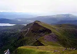
The mountain can be easily climbed from Glen Brittle up Coir' a' Grunnda, going south of Loch Coir' a' Grunnda to the Cuillin ridge and ascending the north ridge to the summit. The alternative of taking the south shoulder from the coastal path up 610 metres (2,000 ft) of scree is tedious, even though it is easy.[10][11][12] From An Garbh-choire there is no easy way up the northeast flank but the north ridge and east ridge can be reached with scrambling.[13] There is an easy and fine ridge walk to Gars-Bheinn.[7]
Notes
References
Citations
- Slessor (1991), p. 244.
- "Sgurr nan Eag, Scotland". www.peakbagger.com. Archived from the original on 30 July 2017.
- "Find paper maps by location". Ordnance Survey.
- Slessor (1991), p. 244–245.
- Butterfield (1986), pp. 262–264.
- Fabian, Little & Williams (1989), pp. 213–214.
- Storer (1996), pp. 100–101.
- Fabian, Little & Williams (1989), p. 215.
- Slessor (1991), p. 224.
- Fabian, Little & Williams (1989), pp. 215,217.
- Butterfield (1986), pp. 260–261.
- Storer (1989), p. 71.
- Fabian, Little & Williams (1989), p. 223.
Works cited
- Butterfield, Irvine (1986). "Chapter 27: The Black Cuillin of Skye". The High Mountains of Britain and Ireland (Book Club Associates ed.). Diadem Books. pp. 258–274.CS1 maint: ref=harv (link)
- Fabian, Derek John; Little, Graham E; Williams, D Noel (1989). The islands of Scotland including Skye. Scottish Mountaineering Trust. ISBN 0-907521-23-1.
- Slessor, Malcolm (1991). "Section 17: The Islands of Mull and Skye". In Bennet, Donald (ed.). The Munros (2nd ed.). Scottish Mountaineering Trust. pp. 230–191. ISBN 0-907521-31-2.
- Storer, Ralph (1989). Skye : walking, scrambling and exploring. Newton Abbot: David & Charles. ISBN 0-7153-9223-9.
- Storer, Ralph (1996). "Route 46: The South Cuillin Ridge (Skye)". 50 Best Routes on Skye and Raasay. David & Charles. pp. 100–101. ISBN 0-7153-0395-3.
External links
- 360Routes.com - Virtual Tour over Sgùrr nan Eag.
| Wikimedia Commons has media related to Sgùrr nan Eag. |