Shahapur, Karnataka
Shahapur is a city and taluka headquarter located in the Yadgir district of Indian state of Karnataka. Shahapur is 597 km north of Bangalore and well connected by road to Gulbarga (70 km), Hyderabad (210 km), Bidar (160 km) and Yadgir (32 km).
Shahapur
Sagaranadu | |
|---|---|
city | |
 Shahapur Location in Karnataka, India | |
| Coordinates: 16.7°N 76.83°E | |
| Country | |
| State | Karnataka |
| District | Yadagiri |
| Lok Sabha Constituency | Raichur |
| Elevation | 428 m (1,404 ft) |
| Population (2011) | |
| • Total | 53,366 |
| Languages | |
| • Official | ಕನ್ನಡ |
| Time zone | UTC+5:30 (IST) |
| PIN | 585223 |
| Telephone code | 08479 |
| Vehicle registration | KA 33 |
| Website | www.shahapuracity.mrc.gov.in |
Geography
Shahapur is located at 16.7°N 76.83°E.[1] It has an average elevation of 428 metres (1404 feet). when you search the karnataka physical map you will see in yadgir district map the hills mentioned by the name SHAHAPUR HILLS these hills spread along shahapur to surpur taluks.
Demographics
As per 2011 Indian census, Shahapur had a population of 57,129. Males constitute 52% of the population and females 48%. Shahapur has an average literacy rate of 52%, lower than the national average of 65.38% and also lower than the state literacy which is 67%: shahapur male literacy is 61%, and female literacy is 43%. In Shahapur, 16% of the population is under 6 years of age.
About
The Town Municipal Council (TMC) Shahapur was constituted in 1954 and this TMC is upgraded (in 2015) as a (CMC) (City Municipal Council). The CMC has 32 wards and equal number of councilors. Shahapura CMC stretches to an area of 13.65 km2. Summer Temperature as high as 45 -43 degree Celsius and Winter Temp-27 degree Celsius
Name
As per the mythology the old name of Shahapur was "Sagar". In support of this name there is historical evidence such as the sobriquet of the Vijayanagara Kingdom's last ruler Ramaraya (son in law of Srikrishna Devaraya), who was also called as "Sagara Sankramanaraya". After the Muslim attack the name of the city was changed to Nusratabad.As per historians after attack "Sagar "village is shifted to the other side of the hill line and the original Sagar has been abandoned for some time and it was called as "Halu Sagar". As time passes and now it is called as "Hali sagar" means Old Sagar. The area between Krishna and Bhima river is called "Sagara Nadu". It consists of Shahapur, Surpur (Shorapur) and Jewargi talukas.
Climate
| Climate data for Shahapura, India | |||||||||||||
|---|---|---|---|---|---|---|---|---|---|---|---|---|---|
| Month | Jan | Feb | Mar | Apr | May | Jun | Jul | Aug | Sep | Oct | Nov | Dec | Year |
| Average high °C (°F) | 30.6 (87.1) |
33.4 (92.1) |
36.6 (97.9) |
38.6 (101.5) |
39.4 (102.9) |
34.7 (94.5) |
31.5 (88.7) |
31.4 (88.5) |
31.3 (88.3) |
31.8 (89.2) |
30.4 (86.7) |
29.6 (85.3) |
33.3 (91.9) |
| Daily mean °C (°F) | 24 (75) |
26.5 (79.7) |
29.5 (85.1) |
31.9 (89.4) |
32.7 (90.9) |
29.2 (84.6) |
27.1 (80.8) |
26.9 (80.4) |
26.7 (80.1) |
26.8 (80.2) |
24.6 (76.3) |
23.2 (73.8) |
27.4 (81.4) |
| Average low °C (°F) | 17.5 (63.5) |
19.6 (67.3) |
22.5 (72.5) |
25.3 (77.5) |
26.0 (78.8) |
23.8 (74.8) |
22.8 (73.0) |
22.5 (72.5) |
22.2 (72.0) |
21.8 (71.2) |
18.9 (66.0) |
16.8 (62.2) |
21.6 (70.9) |
| Average rainfall mm (inches) | 0 (0) |
2 (0.1) |
8 (0.3) |
16 (0.6) |
29 (1.1) |
97 (3.8) |
161 (6.3) |
130 (5.1) |
185 (7.3) |
92 (3.6) |
16 (0.6) |
7 (0.3) |
743 (29.1) |
| Source: Climate-Data.org - Climate Table of Shahapura, Karnataka, India[2] | |||||||||||||
Tourism attractions
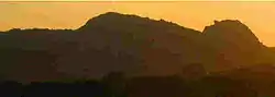
- Sleeping Buddha Hill, made up of four hills.
Taluka
The Shahpur Taluka contains thirty-seven panchayat villages:[3]
- Anabi[4]
- Bendebembali
- Bilar
- Chamnal
- Chatnalli
- Doranhalli
- Gogikona
- Gogipeth
- Gonal
- Gulsaram
- Haiyyal.B.
- Halgera
- Hattigudur
- Hoskera
- Hotpet
- Ibrahimpur[5]
- Kadamgera
- Kakkasgera
- Kannekollur
- Khanapur
- Kollur
- Konkal
- Kurkunda
- Mudbool
- Maddarki
- Naganatagi
- Naikal
- Rastapur
- Sagar
- Sirval (Sirwal)
- T. Wadagera
- Hire Tumkur
- Tadabidi
- Ukkinal
- Ulle Sugoor
- Vadagera (Wadgera)
- Vanadurg (Wandurg)
References
- Falling Rain Genomics, Inc - Shahpur
- "Climate Table of Shahapura, Karnataka, India". Climate-Data.org. Retrieved 31 January 2015.
- "Reports of National Panchayat Directory: Village Panchayat Names of Shahapur, Yadgir, Karnataka". Ministry of Panchayati Raj, Government of India. Archived from the original on 27 February 2013.
- "Anabi Population - Yadgir, Karnataka". Office of the Registrar General & Census Commissioner, India. Archived from the original on 12 December 2016.
- "Ibrahimpur Population - Yadgir, Karnataka". Office of the Registrar General & Census Commissioner, India. Archived from the original on 12 December 2016.
Tadabidi
External links
- https://web.archive.org/web/20090827043023/http://shahapuratown.gov.in/
- http://ibnlive.in.com/news/karnataka-uranium-mining-in-gogi-cleared/182896-60-115.html
- http://www.bhorukapower.com/shahapur.htm
- http://www.hindu.com/2010/07/30/stories/2010073052480300.htm
District HQ: Yadgir | |||||||
| Cities and towns | |||||||
| Villages and other settlements |
| ||||||
| Parks, reserves and places of interest | |||||||