Gulbarga
Gulbarga, also known as Kalaburagi,[2] is a city in the Indian state of Karnataka. It is the administrative headquarters of Gulbarga district and is the largest city in the Hyderabad-Karnataka (also known as Kalyana-Karnataka) region of North Karnataka. Gulbarga is 623 km north of the state capital city of Bangalore and 220 km from Hyderabad. It was part of Hyderabad State and incorporated into the newly formed Mysore State (now known as Karnataka) through the States Reorganisation Act[3] in 1956.
Gulbarga | |
|---|---|
| Kalaburagi | |
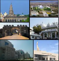 Clockwise from top left, Sharana Basaveshwara Temple, Buddha Vihar, Khwaja Banda Nawaz Dargah, CUK Gulbarga, ESIC Medical College Gulbarga and Gulbarga Fort | |
 Gulbarga Location of Gulbarga in India  Gulbarga Location of Gulbarga in Karnataka | |
| Coordinates: 17.329°N 76.825°E | |
| Country | |
| State | Karnataka |
| District | Gulbarga district |
| Regions of Karnataka | Kalyana-Karnataka |
| Government | |
| • Type | Mayor–Council , Gulbarga City Corporation |
| • Body | District Administration |
| Area | |
| • City Corporation | 192 km2 (74 sq mi) |
| Elevation | 454 m (1,490 ft) |
| Population (2011) | |
| • City Corporation | 533,587[1] |
| • Density | 8,275/km2 (21,430/sq mi) |
| • Metro | 543,147[1] |
| Languages | |
| • Official | Kannada |
| Time zone | UTC+5:30 (IST) |
| PIN | 585101-106 |
| Telephone code | 91(847)-2XXXXXX |
| Vehicle registration | KA-32 |
| Website | kalaburagi |
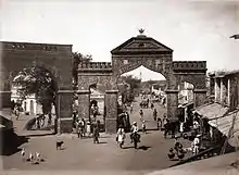
Gulbarga city is governed by a Municipal Corporation and is in the Gulbarga Urban Region. It is called a Sufi city. It has famous religious structures, like the Khwaja Banda Nawaz Dargah, the Sharana Basaveshwara Temple and the Buddha Vihar. It also has a fort built during Bahmani rule. It has many domes like the Hafth Gumbad (seven domes together) and the Shor Gumbad. Gulbarga has the world's largest cannon .[4][5][6][7] Gulbarga has a few architectural marvels built during the Bahamani Kingdom rule, including the Jama Masjid in the Gulbarga Fort. Gulbarga houses the circuit bench of the High Court of Karnataka
History
The history of Gulbarga dates to the 6th century. The Rashtrakutas gained control over the region, but the Chalukyas regained their domain within a short period and reigned supreme for over 200 years. The Kalyani Kalachuris who succeeded them ruled until the 12th century. Around the end of the 12th century, the Yadavas of Devagiri and the Hoysalas of Dwarasamadra destroyed the supremacy of the Chalukyas and Kalachuris of Kalyani. Around the same period, the Kakatiya kings of Warangal came into prominence and the present Gulbarga and Raichur districts formed part of their domain. The Kakatiya power was subdued in 1321 AD and the entire Deccan, including the district of Gulbarga, passed under the control of the Delhi Sultanate.
The revolt of the officers appointed from Delhi resulted in the founding of the Bahmani Sultanate in 1347 CE by Ala-ud-Din Bahman Shah, who chose Gulbarga (Hasanabad) to be the capital.[8] When the Bahamani dynasty came to an end in 1527, the kingdom broke up into five independent Sultanates, Bijapur, Bidar, Berar, Ahmednagar, and Golconda. The present Gulbarga/Gulbarga district came partly under Bidar and partly under Bijapur. The last of these sultanates, Golconda, finally fell to Aurangzeb in 1687.
With the conquest of the Deccan by Aurangzeb in the 17th century, Gulbarga passed under the Mughal Empire. In the early part of the 18th century, with the decline of the Mughal Empire, Asaf Jha, one of Aurangzeb's generals, formed the Hyderabad State, in which a major part of the Gulbarga area was also included. In 1948, Hyderabad State became a part of the Indian Union, and in 1956, excluding two talukas which were annexed to Andhra Pradesh, Gulbarga district became part of new Mysore State.
Gulbarga (Urdu) (city of flowers and gardens) was renamed Kalaburagi (Kannada) (Kal-means stone in Kannada, bur means thorns in Kannada the whole name represents "The Land of stones and thorns") effective 1 November 2014.[9]
Art and architecture
The largest collection of Islamic art is seen only at the domed ceiling and walls are adorned with painting containing calligraphy designs and floral, flower and plants and geometric patterns inside the 14th century tomb of Sufi saint Syed Shah Qhabulullah Husayni with natural colours. By religious restrictions the artist was prohibited from depicting living beings in the interior of tomb, and his imagination was therefore employed either in inventing new designs for religious texts or in adding further delicacy and subtleness to the geometric and floral devices by making the drawings more and more intricate. A small tomb beside the said Sufi's has an excellent work painted flower plants on ceiling. Another vacant Shore Gumbad outside the city has delicate designs on its domed ceiling is superb.
The walls and ceiling of the tomb of Sultan Firuz Shah Bahmani can be appreciated which, although in monotone, represents faithfully the creepers and floral patterns, the numerous geometric devices and calligraphic styles. The most notable building, however, of this period is Jama Masjid of Gulbarga fort, built by a Persian architect named Rafi in 1367 during the reign of Bahmani King Mohammed Shah I.
The glory of the towns in north Karnataka waned with the decline of the Bahmani dynasty, although Barid Shahi and Adil Shahi Kings kept up its beauty during their chequered rule. It suffers from pollution through nickel and lead.
Royal patronage played an important role in the making of Islamic art, as it has in the arts of other cultures. From the 14th century onwards, especially in eastern lands, the books of art provide the best documentation of the courtly patronage.
Geography
The entire district is on the Deccan Plateau, and the elevation ranges from 300 to 750 m above MSL. Two main rivers, the Krishna and Bhima, flow through the district. The predominant soil type is black soil. The district has many tanks, which irrigate the land along with the river. The Upper Krishna Project is a major irrigation venture in the district of Jowar. The main crops are groundnuts, rice, and pulses. Gulbarga is the largest producer of toor dal, or pigeon peas, in Karnataka. Gulbarga is an industrially backward district but is showing signs of growth in the cement, textile, leather and chemical industries. Gulbarga has a university with Medical and Engineering Colleges. Central University of Karnataka (CuK) is located in Kadaganchi, Åland Taluk of Gulbarga.[10] The geographical area of the city is 64 square kilometers.[11]
Climate
The climate of the district is generally dry, with temperatures ranging from 8 °C to 45 °C and an annual rainfall of about 750 mm. The year in Gulbarga is divided into three main seasons. The summer lasts from late February to mid-June. It is followed by the southwest monsoon, which lasts from late June to late September. This is then followed by dry winter weather until mid-January.
| Climate data for Gulbarga (1981–2010, extremes 1901–2012) | |||||||||||||
|---|---|---|---|---|---|---|---|---|---|---|---|---|---|
| Month | Jan | Feb | Mar | Apr | May | Jun | Jul | Aug | Sep | Oct | Nov | Dec | Year |
| Record high °C (°F) | 36.2 (97.2) |
39.4 (102.9) |
43.0 (109.4) |
45.1 (113.2) |
46.1 (115.0) |
46.0 (114.8) |
38.4 (101.1) |
37.8 (100.0) |
37.4 (99.3) |
38.2 (100.8) |
35.6 (96.1) |
35.1 (95.2) |
46.1 (115.0) |
| Average high °C (°F) | 31.3 (88.3) |
34.4 (93.9) |
37.8 (100.0) |
40.2 (104.4) |
40.6 (105.1) |
35.6 (96.1) |
32.3 (90.1) |
31.3 (88.3) |
32.1 (89.8) |
32.3 (90.1) |
31.4 (88.5) |
30.5 (86.9) |
34.2 (93.6) |
| Average low °C (°F) | 16.3 (61.3) |
18.6 (65.5) |
22.3 (72.1) |
25.1 (77.2) |
25.8 (78.4) |
23.8 (74.8) |
23.0 (73.4) |
22.5 (72.5) |
22.6 (72.7) |
21.2 (70.2) |
18.5 (65.3) |
15.8 (60.4) |
21.3 (70.3) |
| Record low °C (°F) | 6.7 (44.1) |
9.4 (48.9) |
12.8 (55.0) |
13.3 (55.9) |
17.8 (64.0) |
12.7 (54.9) |
17.2 (63.0) |
16.4 (61.5) |
17.8 (64.0) |
10.0 (50.0) |
7.8 (46.0) |
5.6 (42.1) |
5.6 (42.1) |
| Average rainfall mm (inches) | 4.1 (0.16) |
1.9 (0.07) |
5.9 (0.23) |
17.2 (0.68) |
26.0 (1.02) |
109.4 (4.31) |
127.1 (5.00) |
152.8 (6.02) |
194.2 (7.65) |
99.9 (3.93) |
19.7 (0.78) |
4.2 (0.17) |
762.3 (30.01) |
| Average rainy days | 0.4 | 0.1 | 0.5 | 1.4 | 2.3 | 6.4 | 8.9 | 8.9 | 9.0 | 5.4 | 1.6 | 0.2 | 45.0 |
| Average relative humidity (%) (at 17:30 IST) | 34 | 28 | 23 | 23 | 28 | 48 | 58 | 61 | 60 | 52 | 43 | 37 | 41 |
| Source: India Meteorological Department[12][13] | |||||||||||||
Demographics
As of the 2011 Indian census,[1] Gulbarga city has a population of 533,587. Males constitute 55% of the population and females 45%. Gulbarga has an average literacy rate of 67%, higher than the national average of 59.5%. The male literacy is 70%, while that of females is 30%. In Gulbarga, 15% of the population is under 6 years of age. Kannada, Deccani Urdu and English are the main languages.
Politics
Gulbarga has been home to two ex-chief ministers of Karnataka, namely Veerendra Patil (1968–1971, 1988–1992) and Dharam Singh (2004–2006); both belonged to the Indian National Congress party. Mallikarjun Kharge is the former Member of Parliament and was also formerly the Union Minister for Railways and opposition leader. The Member of Parliament is Umesh. G. Jadhav who emerged victorious in the Lok Sabha elections of 2019 from Gulbarga Lok Sabha constituency.[14]
References
| Wikivoyage has a travel guide for Gulbarga. |
| Wikimedia Commons has media related to Gulbarga. |
- "Gulbarga Population Census 2011 - 2019". Census 2011. Retrieved 4 February 2019.
- "Kalaburagi". indiatoday.intoday.in. Retrieved 2 May 2016.
- "Central Government The States Reorganisation Act, 1956" (PDF). indiaenvironmentportal.org.in. Retrieved 18 August 2016.
- "Remembering a Sufi saint". www.thehindu.com. Retrieved 26 September 2017.
- "KALABURAGI CITY CORPORATION". www.gulbargacity.mrc.gov.in/. Retrieved 26 September 2017.
- "The Haft Gumbaz–Gulbarga". hariexploresindia.wordpress.com. 14 November 2011. Retrieved 26 September 2017.
- "Remains of a grand dream". www.deccanherald.com/. Retrieved 26 September 2017.
- Sen, Sailendra (2013). A Textbook of Medieval Indian History. Primus Books. pp. 106–108. ISBN 978-9-38060-734-4.
- Variyar, Mugdha (1 November 2014). "Bangalore Wakes up to 'Bengaluru'; 11 Other Karnataka Cities Renamed". IBTimes. Retrieved 16 May 2015.
- //http://www.cuk.ac.in//
- "Unauthorized Request Blocked".
- "Station: Gulbarga Climatological Table 1981–2010" (PDF). Climatological Normals 1981–2010. India Meteorological Department. January 2015. pp. 299–300. Archived from the original (PDF) on 5 February 2020. Retrieved 10 April 2020.
- "Extremes of Temperature & Rainfall for Indian Stations (Up to 2012)" (PDF). India Meteorological Department. December 2016. p. M96. Archived from the original (PDF) on 5 February 2020. Retrieved 10 April 2020.
- "Lok Sabha Result 2019: कर्नाटक की गुलबर्गा सीट पर बीजेपी के उमेश जाधव ने कांग्रेस के मल्लिकार्जुन खड़गे को दी शिकस्त". Hindustan (in Hindi). Retrieved 25 May 2019.
| Authority control |
|---|